Difference between revisions of "2019-02-20 51 7"
imported>GeorgDerReisende (new report) |
imported>GeorgDerReisende (expedition report for Lünen) |
||
| Line 1: | Line 1: | ||
| − | |||
| − | |||
| − | |||
| − | |||
| − | |||
| − | |||
| − | |||
| − | |||
| − | |||
| − | |||
{{meetup graticule | {{meetup graticule | ||
| lat=51 | | lat=51 | ||
| Line 19: | Line 9: | ||
== Location == | == Location == | ||
| − | + | ||
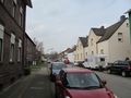
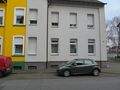
| + | The hash lay in front of the house Von-Born-Straße 32 in Lünen. | ||
== Participants == | == Participants == | ||
| − | + | ||
| − | + | [[User:GeorgDerReisende|GeorgDerReisende]] | |
== Plans == | == Plans == | ||
| − | + | ||
| + | Traveling by public transport to Lünen and walking to the hash. | ||
== Expedition == | == Expedition == | ||
| − | |||
| − | + | I left home at 9 a.m. and by two trams, two trains and a bus I arrived at Lünen. Then I walked to the hash and found it at the front of the house in Lünen. As always, if the hash falls in front of a house, I cannot get the exact coordinates, while standing there. My Garmin always tells me, that I am meters away. This time I could get a four meter shot, still standing at the hash. | |
| − | |||
== Photos == | == Photos == | ||
| − | |||
| − | |||
| − | |||
<gallery perrow="5"> | <gallery perrow="5"> | ||
| + | 2019-02-20 51 7 GeorgDerReisende 8623.jpg | arriving by bus | ||
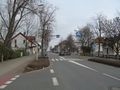
| + | 2019-02-20 51 7 GeorgDerReisende 8714.jpg | the Von-Born-Straße | ||
| + | 2019-02-20 51 7 GeorgDerReisende 8715.jpg | house nr 32 | ||
| + | 2019-02-20 51 7 GeorgDerReisende 8716.jpg | the front of the house | ||
| + | 2019-02-20 51 7 GeorgDerReisende 8717.jpg | standing at the hash, the Garmin tells me, I am four meters away | ||
| + | 2019-02-20 51 7 GeorgDerReisende 8718.jpg | looking north | ||
| + | 2019-02-20 51 7 GeorgDerReisende 8719.jpg | opposite | ||
| + | 2019-02-20 51 7 GeorgDerReisende 8720.jpg | looking south | ||
| + | 2019-02-20 51 7 GeorgDerReisende 8721.jpg | the geohasher | ||
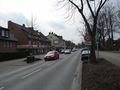
| + | 2019-02-20 51 7 GeorgDerReisende 8723.jpg | the nearby main street, the Münsterstraße to the east | ||
| + | 2019-02-20 51 7 GeorgDerReisende 8724.jpg | the Münsterstraße to the west | ||
</gallery> | </gallery> | ||
| − | + | [[Category:Expeditions]] | |
| − | |||
| − | |||
| − | + | [[Category:Expeditions with photos]] | |
| − | |||
| − | [[Category: | ||
| − | |||
| − | |||
| − | |||
| − | |||
| − | |||
| − | |||
| − | |||
| − | |||
| − | |||
| − | |||
| − | |||
| − | |||
| − | |||
| − | |||
| − | |||
| − | |||
| − | |||
| − | |||
| − | |||
| − | |||
[[Category:Coordinates reached]] | [[Category:Coordinates reached]] | ||
| − | |||
| − | |||
| − | |||
| − | |||
| − | |||
| − | |||
| − | |||
| − | |||
| − | |||
| − | |||
| − | |||
| − | |||
| − | |||
| − | |||
| − | |||
| − | |||
| − | |||
| − | |||
Revision as of 08:46, 21 February 2019
| Wed 20 Feb 2019 in 51,7: 51.6245309, 7.5468889 geohashing.info google osm bing/os kml crox |
Location
The hash lay in front of the house Von-Born-Straße 32 in Lünen.
Participants
Plans
Traveling by public transport to Lünen and walking to the hash.
Expedition
I left home at 9 a.m. and by two trams, two trains and a bus I arrived at Lünen. Then I walked to the hash and found it at the front of the house in Lünen. As always, if the hash falls in front of a house, I cannot get the exact coordinates, while standing there. My Garmin always tells me, that I am meters away. This time I could get a four meter shot, still standing at the hash.
Photos
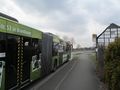
arriving by bus
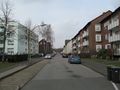
the Von-Born-Straße
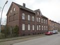
house nr 32
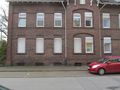
the front of the house
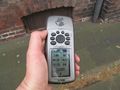
standing at the hash, the Garmin tells me, I am four meters away
looking north
opposite
looking south
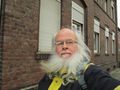
the geohasher
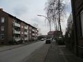
the nearby main street, the Münsterstraße to the east
the Münsterstraße to the west


