Difference between revisions of "2019-05-11 62 29"
imported>Kripakko |
imported>Kripakko |
||
| Line 1: | Line 1: | ||
| − | |||
| − | |||
| − | |||
| − | |||
| − | |||
| − | |||
| − | |||
| − | |||
| − | |||
| − | |||
{{meetup graticule | {{meetup graticule | ||
| lat=62 | | lat=62 | ||
| Line 15: | Line 5: | ||
}} | }} | ||
| − | |||
__NOTOC__ | __NOTOC__ | ||
| Line 29: | Line 18: | ||
== Expedition == | == Expedition == | ||
| − | We parked my father's car about 250 metres to the north from the hashpoint and walked there. There are power lines and an opening in the forest running by the point, and we could walk along it easily. There was still some snow in the ground and standing water in a depression, but we were able to find a path without getting our feet wet. I took some pictures at the hashpoint, and my father took a picture of me. After some seven minutes, we walked back to the car and carried on with our business. | + | We parked my father's car about 250 metres to the north from the hashpoint and walked there. There are power lines and an opening in the forest running by the point, and we could walk along it easily. There was still some snow in the ground and standing water from melted snow in a depression, but we were able to find a path without getting our feet wet. I took some pictures at the hashpoint, and my father took a picture of me. After some seven minutes, we walked back to the car and carried on with our business. |
== Photos == | == Photos == | ||
<gallery perrow="5"> | <gallery perrow="5"> | ||
| + | File:2019-05-11_62_29_01-gpsr.jpg | Hashpoint reached! | ||
| + | File:2019-05-11_62_29_02-forest1.jpg | View from the hashpoint. | ||
| + | File:2019-05-11_62_29_03-forest2.jpg | As my dad said, this is some typical East Finnish forest. | ||
| + | File:2019-05-11_62_29_04-kripakko.jpg | Me at the hashpoint. | ||
| + | File:2019-05-11_62_29_05-path.jpg | Yes, there is still some snow on the ground. | ||
</gallery> | </gallery> | ||
| Line 40: | Line 34: | ||
{{drag-along | latitude = 62 | longitude = 29 | date = 2019-05-11 | partner = his father | name = Kripakko }} | {{drag-along | latitude = 62 | longitude = 29 | date = 2019-05-11 | partner = his father | name = Kripakko }} | ||
| − | |||
| − | |||
[[Category:Expeditions]] | [[Category:Expeditions]] | ||
[[Category:Expeditions with photos]] | [[Category:Expeditions with photos]] | ||
[[Category:Coordinates reached]] | [[Category:Coordinates reached]] | ||
| − | |||
| − | |||
| − | |||
| − | |||
| − | |||
| − | |||
| − | |||
| − | |||
| − | |||
| − | |||
| − | |||
| − | |||
| − | |||
| − | |||
| − | |||
| − | |||
| − | |||
| − | |||
| − | |||
| − | |||
| − | |||
| − | |||
| − | |||
| − | |||
| − | |||
| − | |||
| − | |||
| − | |||
| − | |||
| − | |||
| − | |||
| − | |||
| − | |||
| − | |||
| − | |||
| − | |||
| − | |||
| − | |||
| − | |||
| − | |||
Revision as of 13:07, 12 May 2019
| Sat 11 May 2019 in 62,29: 62.6945594, 29.6311787 geohashing.info google osm bing/os kml crox |
Location
In a forest near the village of Puntarikoski in Kontiolahti.
Participants
- Kripakko
- Kripakko's father
Plans
We had some business unrelated to geohashing nearby today, and because we had plenty of time to spare, I persuaded him to visit the geohash.
Expedition
We parked my father's car about 250 metres to the north from the hashpoint and walked there. There are power lines and an opening in the forest running by the point, and we could walk along it easily. There was still some snow in the ground and standing water from melted snow in a depression, but we were able to find a path without getting our feet wet. I took some pictures at the hashpoint, and my father took a picture of me. After some seven minutes, we walked back to the car and carried on with our business.
Photos
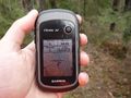
Hashpoint reached!
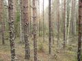
View from the hashpoint.
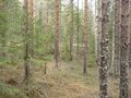
As my dad said, this is some typical East Finnish forest.
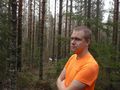
Me at the hashpoint.
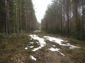
Yes, there is still some snow on the ground.


Achievements
Kripakko earned the Land geohash achievement
|
Kripakko earned the Drag-along achievement
|