Difference between revisions of "2019-05-26 52 9"
From Geohashing
imported>GeorgDerReisende (new report) |
imported>GeorgDerReisende (expedition report for Hagenburg-Altenhagen) |
||
| Line 1: | Line 1: | ||
| + | [[Image:{{{image|2019-05-26 52 9 GeorgDerReisende 0001.jpg}}}|thumb|left]] | ||
| − | |||
| − | |||
| − | |||
| − | |||
| − | |||
| − | |||
| − | |||
| − | |||
| − | |||
{{meetup graticule | {{meetup graticule | ||
| lat=52 | | lat=52 | ||
| Line 19: | Line 11: | ||
== Location == | == Location == | ||
| − | + | ||
| + | The hash lay on a fieldway east of Hagenburg-Altenhagen. | ||
== Participants == | == Participants == | ||
| − | + | ||
| − | + | [[User:GeorgDerReisende|GeorgDerReisende]] | |
== Plans == | == Plans == | ||
| − | + | ||
| + | Today was an election day for the European Parliament. So my plans were: Voting and geohashing. | ||
== Expedition == | == Expedition == | ||
| − | |||
| − | + | At first I went to the voting office and voted. Then I traveled to Altenhagen and walked to the hash. While I actually have no functional GPS I calculated the geohash on the map. The map told me something about 125.2 meters to go from the cycle path and I converted this to 157 steps. I walked along the fieldway and after 157 steps I mentioned to be at the hash. I wrote a marker there and took the usual photos. Then I traveled home. | |
| − | |||
== Photos == | == Photos == | ||
| − | |||
| − | |||
| − | |||
<gallery perrow="5"> | <gallery perrow="5"> | ||
| + | 2019-05-26 52 9 GeorgDerReisende 8829.jpg | the Fasanenhofschule is the voting office for the Fasanenhof quarter | ||
| + | 2019-05-26 52 9 GeorgDerReisende 8845.jpg | with this bus I traveled to Altenhagen, but without a bike | ||
| + | 2019-05-26 52 9 GeorgDerReisende 8883.jpg | this is the fieldway to the hash, 157 steps to go | ||
| + | 2019-05-26 52 9 GeorgDerReisende 8888.jpg | some words on the way | ||
| + | 2019-05-26 52 9 GeorgDerReisende 8889.jpg | looking north | ||
| + | 2019-05-26 52 9 GeorgDerReisende 8890.jpg | looking east | ||
| + | 2019-05-26 52 9 GeorgDerReisende 8891.jpg | looking south | ||
| + | 2019-05-26 52 9 GeorgDerReisende 8892.jpg | looking west | ||
| + | 2019-05-26 52 9 GeorgDerReisende 8893.jpg | the geohasher | ||
</gallery> | </gallery> | ||
| Line 45: | Line 43: | ||
<!-- Add any achievement ribbons you earned below, or remove this section --> | <!-- Add any achievement ribbons you earned below, or remove this section --> | ||
| − | + | {{gratuitous ribbon | color = white | icon = Voting.png | latitude = 52 | longitude = 9 | date = 2019-05-26 | achievement = Democracy Geohash Achievement | description = going voting on the way to the | name = GeorgDerReisende }} | |
| − | |||
| − | |||
| − | + | [[Category:Expeditions]] | |
| − | + | [[Category:Expeditions with photos]] | |
| − | |||
| − | [[Category: | ||
| − | |||
| − | |||
| − | |||
| − | |||
| − | |||
| − | |||
| − | |||
| − | |||
[[Category:Expedition without GPS]] | [[Category:Expedition without GPS]] | ||
| − | |||
| − | |||
| − | |||
| − | |||
| − | |||
| − | |||
| + | {{location|DE|NI|SHG}} | ||
| − | + | [[Category:Coordinates reached]] | |
| − | [[Category:Coordinates | ||
| − | |||
| − | |||
| − | |||
| − | |||
| − | |||
| − | |||
| − | |||
| − | |||
| − | |||
| − | |||
| − | |||
| − | |||
| − | |||
| − | |||
Latest revision as of 14:54, 27 May 2019
| Sun 26 May 2019 in 52,9: 52.4362932, 9.3656433 geohashing.info google osm bing/os kml crox |
Location
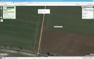
The hash lay on a fieldway east of Hagenburg-Altenhagen.
Participants
Plans
Today was an election day for the European Parliament. So my plans were: Voting and geohashing.
Expedition
At first I went to the voting office and voted. Then I traveled to Altenhagen and walked to the hash. While I actually have no functional GPS I calculated the geohash on the map. The map told me something about 125.2 meters to go from the cycle path and I converted this to 157 steps. I walked along the fieldway and after 157 steps I mentioned to be at the hash. I wrote a marker there and took the usual photos. Then I traveled home.
Photos
Achievements
GeorgDerReisende earned the Democracy Geohash Achievement
|


