Difference between revisions of "2008-06-03 37 -122"
From Geohashing
imported>Mystitat (→Execution) |
imported>Thomcat (Success/failure category added) |
||
| Line 31: | Line 31: | ||
Image:2008-06-03-37-122-08.jpg|Obligatory "smiling like an idiot" picture | Image:2008-06-03-37-122-08.jpg|Obligatory "smiling like an idiot" picture | ||
</gallery> | </gallery> | ||
| + | |||
| + | [[Category:Expeditions]] | ||
| + | [[Category:Expeditions with photos]] | ||
| + | [[Category:Coordinates reached]] | ||
| + | [[Category:Expedition without GPS]] | ||
Revision as of 14:32, 7 August 2008
| Tue 3 Jun 2008 in 37,-122: 37.9579927, -122.1289349 geohashing.info google osm bing/os kml crox |
Planning
- Google Maps link
- I'm planning to get there around 4:00pm, as per usual xkcd meetup time. Looks like there's easy driving access if you go here, then take the little unmarked road to a parking lot within the park. From there, it's a straight walk to the site. (I don't have a gps, so I'm probably going to end up counting the bushes to tell if I'm on the spot.) --Mystitat
Execution
- Mystitat arrived around 4:05. There were lots of dog-walkers and cyclists, but no other geohashers. Took some pictures and hung out until about 4:30.
Mystitat earned the Land geohash achievement
|
Mystitat also earned the No Batteries Geohash.
Photographic Evidence
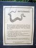
Warnings were made.
Second thoughts were had.
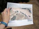
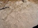
The proof! (Well, I don't actually own a gps ... )
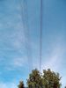
Better proof! (You can see on the satellite view that the exact spot is under power lines.)
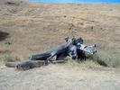
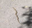
If you squint, this pile of stumps/logs nearby kinda looks like like an octopus...
Signs were left.
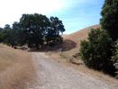
Scenery was beautiful.

Obligatory "smiling like an idiot" picture


