Difference between revisions of "2008-06-07 39 -76"
imported>Thomcat (category and map added) |
imported>Thomcat (Success/failure category added) |
||
| Line 7: | Line 7: | ||
| graticule_link=Baltimore, Maryland | | graticule_link=Baltimore, Maryland | ||
}} | }} | ||
| − | |||
| − | |||
== About == | == About == | ||
| Line 33: | Line 31: | ||
Image:080607E.jpg|By this point I noticed they were nailing signs to any vertical surface, and decided to take my leave of this place. | Image:080607E.jpg|By this point I noticed they were nailing signs to any vertical surface, and decided to take my leave of this place. | ||
</gallery> | </gallery> | ||
| + | |||
| + | [[Category:Expeditions]] | ||
| + | [[Category:Expeditions with photos]] | ||
| + | [[Category:Coordinates not reached]] | ||
| + | [[Category:Failed - No public access]] | ||
Revision as of 17:42, 7 August 2008
| Sat 7 Jun 2008 in Baltimore: 39.5017842, -76.1143708 geohashing.info google osm bing/os kml crox |
About
These coordinates are located in the Baltimore graticule on 2008-06-07. The coordinates are at the very edge of the beach next to what appears to be an Alcohol rehabilitation center. I would presume to state that any visitors should leave Alcohol behind to avoid violent confrontation with the indigenous inhabitants of the site.
39.501784°, -76.114371°
[NOTE] This area does not appear to be fenced off, but may be private property.
Attendance
Zak started to go...but chickenned out after several 'No Trespassing' signs. Probably would have been bolder if the site was farther away and I had more invested in reaching the destination.
- 080607
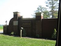
Entering the Ashley Center. Should have gotten pictures of the road: flanked on either side by a row of tall trees, it was very nice.
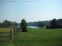
View of the bay through some neighboring houses
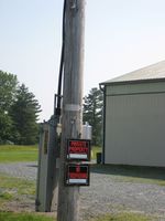
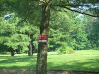
My first sign to leave
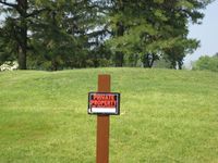
My Second sign to leave
By this point I noticed they were nailing signs to any vertical surface, and decided to take my leave of this place.


