Difference between revisions of "2020-02-29 55 11"
(→Expedition) |
m (→Expedition) |
||
| Line 45: | Line 45: | ||
It's not so much about the achievements for me anymore (though a [[Leap geohash achievement]] in a [[Virgin graticule]] is of course very exciting!) It's more about exploring Denmark, the country i now call home. So even though i knew i couldn't make the exact coordinates, i was very happy to have a look around Vordingborg, and take a wonderful bike ride out along the spit. | It's not so much about the achievements for me anymore (though a [[Leap geohash achievement]] in a [[Virgin graticule]] is of course very exciting!) It's more about exploring Denmark, the country i now call home. So even though i knew i couldn't make the exact coordinates, i was very happy to have a look around Vordingborg, and take a wonderful bike ride out along the spit. | ||
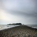
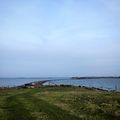
| − | [[File:30FD31A2-8409-410E-BB23-02DED876DD74.jpeg|250px|thumb|right| | + | [[File:30FD31A2-8409-410E-BB23-02DED876DD74.jpeg|250px|thumb|right|A very narrow causeway]] The most exciting moment was this very narrow causeway, where the strip of land between Smålandsfarvandet on the left and Avnø Fjord on the right becomes about 5 metrers across! Once i got to the other side i realised i'd lost signal on my phone, so i couldn't be sure exactly how close i was to the geohash point, but from the Strava map, it seems i got pretty close! |
I was there at exactly 4pm but there was not a single other person to be seen. In fact, i think it's highly likely i was the only person on that almost-island at the time. Possibly the only person to have come that far out in several days. | I was there at exactly 4pm but there was not a single other person to be seen. In fact, i think it's highly likely i was the only person on that almost-island at the time. Possibly the only person to have come that far out in several days. | ||
Revision as of 18:53, 1 March 2020
| Sat 29 Feb 2020 in Næstved, Denmark: 55.0713524, 11.6336988 geohashing.info google osm bing/os kml crox |
Contents
Location
Knudsskovvej, Vordingborg, Sjælland
Location Trivia
The name Knudsskovvej can be translated as Canute's Forest Path. This path seems to go the entire length of the spit.
Participants
Plans
Sermoa, inspired by Macronencer, who was inspired by KarMann, will try to get a Leap geohash achievement. Because it's a saturday, it's on Feb 29, and i'll have just got paid!
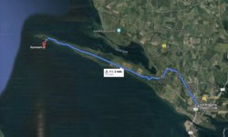
By the looks of it, i can get to within about 600 metres of the hash, which lands in the sea just south of Sjælland. But honestly, that spit looks like an utterly awesome place to explore anyway, leap geohash or not! My idea of starting geohashing again is to find reasons to explore more of Denmark, so yeah! Let the adventures commence!
Astonishingly, it seems as though this will also qualify as a Virgin Graticule achievement!
Detailed Plans
I like details!
I will take my bike on the 11.37 Regional-tog from Københavns Hovedbanegård, arriving at Vordingborg at 12.49.
I will probably have a little look around Vordingborg, and get some sandwiches and drinks to take with me on the bike ride.
At 14.00 i will set off on the bike ride and enjoy the long spit between Avnø Fjord and Smålandsfarvandet. Google Maps says it should take about an hour to cycle to as close the geohash as possible, but i'll allow plenty of time because i'm sure i'll want to stop and take lots of photos!
I will aim to be at the edge of the spit at around 16.00, as close as i can get to the geohash point without getting too wet!
Expedition
It has to be said, my return to geohashing after a ten year absence was a huge success!
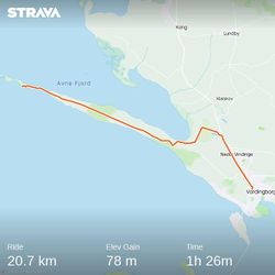
It's not so much about the achievements for me anymore (though a Leap geohash achievement in a Virgin graticule is of course very exciting!) It's more about exploring Denmark, the country i now call home. So even though i knew i couldn't make the exact coordinates, i was very happy to have a look around Vordingborg, and take a wonderful bike ride out along the spit.
The most exciting moment was this very narrow causeway, where the strip of land between Smålandsfarvandet on the left and Avnø Fjord on the right becomes about 5 metrers across! Once i got to the other side i realised i'd lost signal on my phone, so i couldn't be sure exactly how close i was to the geohash point, but from the Strava map, it seems i got pretty close!
I was there at exactly 4pm but there was not a single other person to be seen. In fact, i think it's highly likely i was the only person on that almost-island at the time. Possibly the only person to have come that far out in several days.
I didn't go all the way to the end of the spit because the terrrain became very tough, there were a lot of cows giving me suspicious looks, and i was keen to get back over the causeway, not knowing if it was tidal. I definitely didn't fancy getting stuck on cow island with no phone signal when it began to get dark!
In all, i must have cycled over 40km yesterday. I definitely felt very tired when i got back to Vordingborg, but i had time for a class of wine before taking the train back to Copenhagen!
Photos
Achievements
Sermoa earned the Leap geohash achievement 2020
|

