Difference between revisions of "2018-08-29 52 9"
From Geohashing
imported>Fippe ({{location|DE|NI|NI}} Category:Expeditions by Fippe) |
m |
||
| Line 32: | Line 32: | ||
{{#vardefine:ribbonwidth|700px}} | {{#vardefine:ribbonwidth|700px}} | ||
{{land geohash|latitude=52|longitude=9|date=2018-08-29|name=[[User:Fippe|Fippe]]|image=2018-08-29 52 09 05 Geohash.jpg}} | {{land geohash|latitude=52|longitude=9|date=2018-08-29|name=[[User:Fippe|Fippe]]|image=2018-08-29 52 09 05 Geohash.jpg}} | ||
| − | {{OpenStreetMap achievement|latitude=52|longitude= | + | {{OpenStreetMap achievement|latitude=52|longitude=9|date=2018-08-29|name=[[User:Fippe|Fippe]]|OSMlink=62115219}} |
__NOTOC__ | __NOTOC__ | ||
Revision as of 16:21, 26 March 2020
| Wed 29 Aug 2018 in Hannover: 52.6309156, 9.1829821 geohashing.info google osm bing/os kml crox |
Location
This Geohash is located on a field near Nienburg.
Participants
Expedition
I took the train to Nienburg and walked to the geohash from there. Nienburg is on the river Weser, and has a nice Old City, both of which I saw on the expedition. I also walked through a path which had lot's of apple trees.
This geohash was located about 50 meters from the edge of a harvested field, so I could reach the coordinates. There is a hydrant next to the field, which I added to OpenStreetMap.
Photos

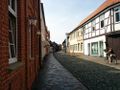
Nienburg's Old City
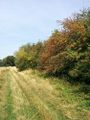
The path to this Geohash
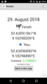
Proof
This Geohash
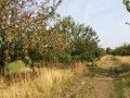
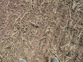
Apple trees


Achievements
Fippe earned the Land geohash achievement
|
Fippe earned the OpenStreetMap achievement
|