Difference between revisions of "2020-04-25 55 13"
(Init) |
(Documented expedition) |
||
| Line 1: | Line 1: | ||
| − | + | [[Image:{{{Image|20200425_55_13_duck.jpg}}}|thumb|left]] | |
| − | + | {{meetup graticule | |
| − | [[Image:{{{ | ||
| − | |||
| − | |||
| − | |||
| − | |||
| − | |||
| − | |||
| lat=55 | | lat=55 | ||
| lon=13 | | lon=13 | ||
| date=2020-04-25 | | date=2020-04-25 | ||
| − | }} | + | }} |
__NOTOC__ | __NOTOC__ | ||
== Location == | == Location == | ||
| − | + | This Geohash is located by a road in [[wikipedia:Skurup|Skurup]] | |
== Participants == | == Participants == | ||
| − | + | [[user:GnuX|gnuX]] | |
| − | + | Emeli | |
== Plans == | == Plans == | ||
| − | + | Very reachable geohash. The plan was to take the car out to Skurup train station (there were chargers there so we could charge the car) and then take a short walk to the Hash. | |
== Expedition == | == Expedition == | ||
| − | + | Things went to plan :) We arrived at the hash just before 14:00, took some strange selfies by the road signs, and then looked for some place to have our lunch. We saw a small pond nearby on the map, so that's where we headed. Once there we were immediately harrased by the local "wildlife" as soon as we got our sandwiches out. We'll have to remember to bring seeds along for future geohashing because [https://www.thespruce.com/is-feeding-ducks-bread-bad-386564 don't feed ducks bread!] | |
| − | |||
| − | |||
| − | |||
== Photos == | == Photos == | ||
| Line 34: | Line 24: | ||
--> | --> | ||
<gallery perrow="5"> | <gallery perrow="5"> | ||
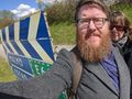
| + | File:20200425_55_13_when-in-europe.jpg|When in europe... | ||
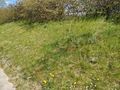
| + | File:20200425_55_13_the-hash.jpg|The location of the hash | ||
| + | File:20200425_55_13_signs.jpg|It was right next to some road signs | ||
| + | File:20200425_55_13_pond.jpg|Lunch view | ||
| + | File:20200425_55_13_local-wildlife.jpg|The local street gang | ||
| + | File:20200425_55_13_duck.jpg|Not a duck | ||
| + | File:20200425_55_13_proof.jpg|The proof! | ||
</gallery> | </gallery> | ||
| − | |||
| − | |||
| − | |||
| − | |||
| − | |||
| − | |||
| − | |||
| − | |||
| − | |||
| − | |||
| − | |||
| − | |||
| − | |||
| − | |||
| − | |||
| − | |||
| − | |||
| − | |||
[[Category:Expeditions]] | [[Category:Expeditions]] | ||
| − | |||
[[Category:Expeditions with photos]] | [[Category:Expeditions with photos]] | ||
| − | |||
| − | |||
| − | |||
| − | |||
| − | |||
[[Category:Coordinates reached]] | [[Category:Coordinates reached]] | ||
| − | |||
| − | |||
| − | |||
| − | |||
| − | |||
| − | |||
| − | |||
| − | |||
| − | |||
| − | |||
| − | |||
| − | |||
| − | |||
| − | |||
| − | |||
| − | |||
| − | |||
| − | |||
Revision as of 15:33, 25 April 2020

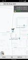
| Sat 25 Apr 2020 in 55,13: 55.4832989, 13.5031892 geohashing.info google osm bing/os kml crox |
Location
This Geohash is located by a road in Skurup
Participants
gnuX Emeli
Plans
Very reachable geohash. The plan was to take the car out to Skurup train station (there were chargers there so we could charge the car) and then take a short walk to the Hash.
Expedition
Things went to plan :) We arrived at the hash just before 14:00, took some strange selfies by the road signs, and then looked for some place to have our lunch. We saw a small pond nearby on the map, so that's where we headed. Once there we were immediately harrased by the local "wildlife" as soon as we got our sandwiches out. We'll have to remember to bring seeds along for future geohashing because don't feed ducks bread!
Photos

When in europe...
The location of the hash
It was right next to some road signs
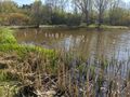
Lunch view
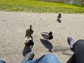
The local street gang
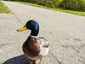
Not a duck
The proof!


