Difference between revisions of "2020-05-19 62 29"
(Created page with "{{subst:Expedition |lat = 62 |lon = 29 |date = 2020-05-19 }}") |
|||
| Line 1: | Line 1: | ||
| − | + | {{meetup graticule | |
| − | |||
| − | |||
| − | |||
| − | |||
| − | |||
| − | |||
| − | |||
| − | |||
| lat=62 | | lat=62 | ||
| lon=29 | | lon=29 | ||
| date=2020-05-19 | | date=2020-05-19 | ||
| − | }} | + | }} |
__NOTOC__ | __NOTOC__ | ||
== Location == | == Location == | ||
| − | + | In a forest in Jaamankangas. | |
== Participants == | == Participants == | ||
| − | + | *[[User:Kripakko|Kripakko]] | |
| − | |||
== Plans == | == Plans == | ||
| − | + | I realised at some point during the day that today's hashpoint is quite close. It would be rather trivial to cycle to the nearest point on the road and walk some 150 metres through the woods. It took me until late evening to actually leave for the visit. | |
== Expedition == | == Expedition == | ||
| − | + | I left from home at about half past ten in the evening. The sun had already set at 21:59, but it was still almost as bright as in the middle of the day. In fact, it would have been much brighter if the sky had not been cloudy. This is not surprising since I live 4° south of the Arctic Circle and the summer solstice is only a month away. The light was however not quite enough for my crappy camera to take good photographs, so I had to crank the sensitivity up to eleven, and my photos still ended up dark. | |
| + | |||
| + | I cycled as close as possible and walked the rest like I had planned. There was enough daylight to walk in the forest without any problems. I did not even bring a lamp with me, for I trusted that I can do fine without one. The hashpoint lay on a treeless line that has at some point been used by forest work vehicles. Walking back to the bicycle, I found out that the line lead to the road and was much easier and faster to walk through than the woods. I ended up maybe thirty meters away from the bicycle. Had I hopped off the bicycle a little earlier, I could have noticed this line immediately and saved a few minutes. | ||
| − | + | Afterwards, I increased the brightness and contrast of the photos so that they would look somewhat similar to what the human eye could see. The colours worked out quite nicely, but much detail was still lost. Oh well. At least it is better than nothing. | |
| − | |||
== Photos == | == Photos == | ||
| − | <!-- | + | <gallery perrow="6"> |
| − | Image:2020- | + | Image:2020-05-19_62_29_01-road.jpg | The last gravel road that I cycled on. |
| − | -- | + | Image:2020-05-19_62_29_02-bicycle.jpg | Bicycle parked on the roadside, 150 metres to go. |
| − | + | Image:2020-05-19_62_29_03-gpsr.jpg | Hashpoint reached! | |
| + | Image:2020-05-19_62_29_04-hashpoint1.jpg | Some landscape at the hashpoint. The lights come from the nearby house. | ||
| + | Image:2020-05-19_62_29_05-hashpoint2.jpg | The treeless line on which the hashpoint was. | ||
| + | Image:2020-05-19_62_29_06-selfie.jpg | Me at the hashpoint. | ||
</gallery> | </gallery> | ||
== Achievements == | == Achievements == | ||
{{#vardefine:ribbonwidth|800px}} | {{#vardefine:ribbonwidth|800px}} | ||
| − | + | {{land geohash | latitude = 62 | longitude = 29 | date = 2020-05-19 | name = Kripakko}} | |
| − | + | {{bicycle geohash | latitude = 62 | longitude = 29 | date = 2020-05-19 | name = Kripakko | distance = 25.6 km | bothways = true}} | |
| − | |||
| − | |||
| − | |||
| − | |||
| − | |||
| − | |||
| − | |||
| − | |||
| − | |||
| − | |||
| − | |||
| − | |||
| − | |||
[[Category:Expeditions]] | [[Category:Expeditions]] | ||
| − | |||
[[Category:Expeditions with photos]] | [[Category:Expeditions with photos]] | ||
| − | |||
| − | |||
| − | |||
| − | |||
| − | |||
[[Category:Coordinates reached]] | [[Category:Coordinates reached]] | ||
| − | |||
| − | |||
| − | |||
| − | |||
| − | |||
| − | |||
| − | |||
| − | |||
| − | |||
| − | |||
| − | |||
| − | |||
| − | |||
| − | |||
| − | |||
| − | |||
| − | |||
| − | |||
Revision as of 00:44, 20 May 2020
| Tue 19 May 2020 in 62,29: 62.7055884, 29.7794530 geohashing.info google osm bing/os kml crox |
Location
In a forest in Jaamankangas.
Participants
Plans
I realised at some point during the day that today's hashpoint is quite close. It would be rather trivial to cycle to the nearest point on the road and walk some 150 metres through the woods. It took me until late evening to actually leave for the visit.
Expedition
I left from home at about half past ten in the evening. The sun had already set at 21:59, but it was still almost as bright as in the middle of the day. In fact, it would have been much brighter if the sky had not been cloudy. This is not surprising since I live 4° south of the Arctic Circle and the summer solstice is only a month away. The light was however not quite enough for my crappy camera to take good photographs, so I had to crank the sensitivity up to eleven, and my photos still ended up dark.
I cycled as close as possible and walked the rest like I had planned. There was enough daylight to walk in the forest without any problems. I did not even bring a lamp with me, for I trusted that I can do fine without one. The hashpoint lay on a treeless line that has at some point been used by forest work vehicles. Walking back to the bicycle, I found out that the line lead to the road and was much easier and faster to walk through than the woods. I ended up maybe thirty meters away from the bicycle. Had I hopped off the bicycle a little earlier, I could have noticed this line immediately and saved a few minutes.
Afterwards, I increased the brightness and contrast of the photos so that they would look somewhat similar to what the human eye could see. The colours worked out quite nicely, but much detail was still lost. Oh well. At least it is better than nothing.
Photos
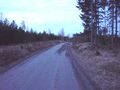
The last gravel road that I cycled on.
Bicycle parked on the roadside, 150 metres to go.
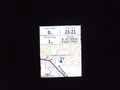
Hashpoint reached!
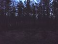
Some landscape at the hashpoint. The lights come from the nearby house.
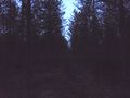
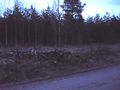
The treeless line on which the hashpoint was.
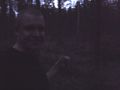
Me at the hashpoint.


Achievements
Kripakko earned the Land geohash achievement
|
Kripakko earned the Bicycle geohash achievement
|