Difference between revisions of "2018-05-21 50 7"
imported>FippeBot m (Location) |
m (→Expedition: fix grammar) |
||
| Line 16: | Line 16: | ||
When writing the report for my [[2018-05-19 51 6|2018-05-19]] trip, I suddenly realized that it's the '''10th [[Geohashing Day]]'''! I immediately checked nearby hashes and found the ([[50,7]]) one reasonably reachable. I then grabbed my bicycle (for the ~four km from the nearest train station to the hash) and got on my way at around 4:00 pm. After arriving in [[wikipedia:de:Stadt_Blankenberg|Stadt Blankenberg]] [[Image:Flag of Germany.png|15px]] shortly after 5:30 pm, I jumped on my bike and struggled to get up the hills. The surroundings were surprisingly steep - I obviously didn't do enough research before. The trip to the hash was only around 5 km, but it took about half an hour to get there as I had to take several <s>breaks</s> pictures, for example of the [[wikipedia:de:Burg_Blankenberg_(Sieg)|Burg Blankenberg]] [[Image:Flag of Germany.png|15px]]. | When writing the report for my [[2018-05-19 51 6|2018-05-19]] trip, I suddenly realized that it's the '''10th [[Geohashing Day]]'''! I immediately checked nearby hashes and found the ([[50,7]]) one reasonably reachable. I then grabbed my bicycle (for the ~four km from the nearest train station to the hash) and got on my way at around 4:00 pm. After arriving in [[wikipedia:de:Stadt_Blankenberg|Stadt Blankenberg]] [[Image:Flag of Germany.png|15px]] shortly after 5:30 pm, I jumped on my bike and struggled to get up the hills. The surroundings were surprisingly steep - I obviously didn't do enough research before. The trip to the hash was only around 5 km, but it took about half an hour to get there as I had to take several <s>breaks</s> pictures, for example of the [[wikipedia:de:Burg_Blankenberg_(Sieg)|Burg Blankenberg]] [[Image:Flag of Germany.png|15px]]. | ||
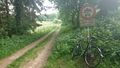
| − | When arriving close to the hash, I locked up my bicycle and | + | When arriving close to the hash, I locked up my bicycle and continued on foot. The hash was located about 10m into the forest next to a grass field. I took quite a long hash dance to lock in close enough to claim a success - likely due to the limited GPS reception in the forest. I left a marker on a nearby tree, took some more pictures and headed back to the station. On the way down, I took a nice rest on a comfortable bench and regained some strength. Further down, I found a nice small path which was fun to ride downhill (for most of the time). Several times, I had to break sharply to avoid running over trees blocking the way and I had to carry the bike over it. Still it was a great, spontaneous trip to celebrate the 10th Geohashing Day! |
== Photos == | == Photos == | ||
Revision as of 17:18, 5 July 2020

| Mon 21 May 2018 in 50,7: 50.7499123, 7.3766712 geohashing.info google osm bing/os kml crox |
Location
In a forest close to Stadt Blankenberg ![]() (Hennef, Germany).
(Hennef, Germany).
Participants
Expedition
When writing the report for my 2018-05-19 trip, I suddenly realized that it's the 10th Geohashing Day! I immediately checked nearby hashes and found the (50,7) one reasonably reachable. I then grabbed my bicycle (for the ~four km from the nearest train station to the hash) and got on my way at around 4:00 pm. After arriving in Stadt Blankenberg ![]() shortly after 5:30 pm, I jumped on my bike and struggled to get up the hills. The surroundings were surprisingly steep - I obviously didn't do enough research before. The trip to the hash was only around 5 km, but it took about half an hour to get there as I had to take several
shortly after 5:30 pm, I jumped on my bike and struggled to get up the hills. The surroundings were surprisingly steep - I obviously didn't do enough research before. The trip to the hash was only around 5 km, but it took about half an hour to get there as I had to take several breaks pictures, for example of the Burg Blankenberg ![]() .
.
When arriving close to the hash, I locked up my bicycle and continued on foot. The hash was located about 10m into the forest next to a grass field. I took quite a long hash dance to lock in close enough to claim a success - likely due to the limited GPS reception in the forest. I left a marker on a nearby tree, took some more pictures and headed back to the station. On the way down, I took a nice rest on a comfortable bench and regained some strength. Further down, I found a nice small path which was fun to ride downhill (for most of the time). Several times, I had to break sharply to avoid running over trees blocking the way and I had to carry the bike over it. Still it was a great, spontaneous trip to celebrate the 10th Geohashing Day!
Photos
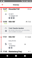
Spontaneous train trip towards Blankenberg
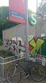
Preparing for the bicycle trip
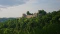
View towards Burg Blankenberg

Securing the bicycle for the final meters
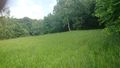
View towards the hash
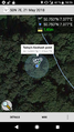
Proof #1
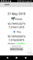
Proof #2
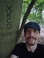
Stupid grin™ (incl. marker)
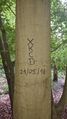
Marker on a nearby tree
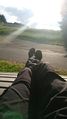
Relaxing on a bench o the way back
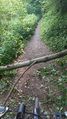
Trees on the path
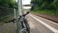
Waiting for the train back


Achievements
pah
|