Difference between revisions of "2020-08-27 48 7"
From Geohashing
| Line 13: | Line 13: | ||
I plan to cycle to Albé in the afternoon. From there, I will probably go to the ''Val d'Argent'' valley via Fouchy. | I plan to cycle to Albé in the afternoon. From there, I will probably go to the ''Val d'Argent'' valley via Fouchy. | ||
| − | |||
== Expedition == | == Expedition == | ||
| + | The ride from home to Albé was very easy. I then had to climb a steep dirt path with a 14% gradient for 800 meters, which was rather slippery for my bicycle's road tires. I finally reached the coordinates around 14:30, took some pictures and went to Villé to eat a quiche and two pieces of cake. | ||
| + | |||
| + | I then continued my route through the Vosges moutains, climbing the ''Col de Fouchy'' and the ''Col d'Adelspach'' before a long descent to Ribeauvillé. | ||
== Photos == | == Photos == | ||
<gallery perrow="5"> | <gallery perrow="5"> | ||
| + | Image:2020-08-27 48 7 01.jpg | Cycling down the ''Val de Villé'' | ||
| + | Image:2020-08-27 48 7 02.jpg | Arriving in Albé | ||
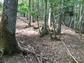
| + | Image:2020-08-27 48 7 03.jpg | A very steep path | ||
| + | Image:2020-08-27 48 7 04.jpg | Let's leave my bicycle here | ||
| + | Image:2020-08-27 48 7 05.jpg | The geohash | ||
| + | Image:2020-08-27 48 7 06.jpg | Stupid grin | ||
| + | Image:2020-08-27 48 7 07.jpg | The view from Adelspach | ||
</gallery> | </gallery> | ||
== Achievements == | == Achievements == | ||
{{#vardefine:ribbonwidth|800px}} | {{#vardefine:ribbonwidth|800px}} | ||
| − | -- | + | {{land geohash |
| + | | latitude = 48 | ||
| + | | longitude = 7 | ||
| + | | date = 2020-08-27 | ||
| + | | name = [[User:Baarde|Baarde]] | ||
| + | }} | ||
| + | {{bicycle geohash | ||
| + | | latitude = 48 | ||
| + | | longitude = 7 | ||
| + | | date = 2020-08-27 | ||
| + | | name = [[User:Baarde|Baarde]] | ||
| + | | distance = 34 km | ||
| + | | bothways = true | ||
| + | }} | ||
__NOTOC__ | __NOTOC__ | ||
Revision as of 09:02, 28 August 2020
| Thu 27 Aug 2020 in 48,7: 48.3632119, 7.3175209 geohashing.info google osm bing/os kml crox |
Location
On a foothill above Albé, in the Val de Villé valley.
Participants
Plans
I plan to cycle to Albé in the afternoon. From there, I will probably go to the Val d'Argent valley via Fouchy.
Expedition
The ride from home to Albé was very easy. I then had to climb a steep dirt path with a 14% gradient for 800 meters, which was rather slippery for my bicycle's road tires. I finally reached the coordinates around 14:30, took some pictures and went to Villé to eat a quiche and two pieces of cake.
I then continued my route through the Vosges moutains, climbing the Col de Fouchy and the Col d'Adelspach before a long descent to Ribeauvillé.
Photos
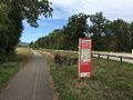
Cycling down the Val de Villé
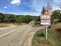
Arriving in Albé
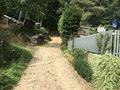
A very steep path
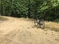
Let's leave my bicycle here
The geohash
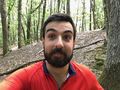
Stupid grin
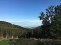
The view from Adelspach


Achievements
Baarde earned the Land geohash achievement
|
Baarde earned the Bicycle geohash achievement
|