Difference between revisions of "2020-07-31 48 7"
From Geohashing
m (→Photos) |
|||
| Line 20: | Line 20: | ||
== Photos == | == Photos == | ||
| − | <gallery | + | <gallery> |
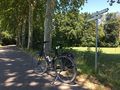
Image:2020-07-31_48_7_01.jpg | Taking the EV15 at Marckolsheim | Image:2020-07-31_48_7_01.jpg | Taking the EV15 at Marckolsheim | ||
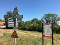
Image:2020-07-31_48_7_02.jpg | Exiting the EV15 at Neunkirch | Image:2020-07-31_48_7_02.jpg | Exiting the EV15 at Neunkirch | ||
Revision as of 14:44, 2 October 2020
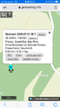
| Fri 31 Jul 2020 in 48,7: 48.3069398, 7.6326234 geohashing.info google osm bing/os kml crox |
Location
In a forest near Neunkirch (Friesenheim).
Participants
Plans
The coordinates are located near the northern branch of the Rhone-Rhine Canal. Ideal for a bike ride on the EuroVelo 15.
Expedition
I took the EuroVelo 15 at Marckolsheim. From there it was a straight route along the Rhone-Rhine Canal until Neunkirch. The coordinate was located in a small forest near the hamlet, in the middle of a half-buried path. I arrived there at 13:10. Easy!
In order to use a different route on the way back, I continued a little bit on the EV15, crossed the Rhine with the ferry at Rhinau and took a small detour across Germany before crossing back on the Sasbach-Marckolsheim bridge.
Photos
Taking the EV15 at Marckolsheim
Exiting the EV15 at Neunkirch

Stupid grin
Coordinates reached


Achievements
Baarde earned the Land geohash achievement
|
Baarde earned the Bicycle geohash achievement
|