Difference between revisions of "2020-10-28 43 -79"
([live picture]Waitin for the streetcar) |
|||
| Line 1: | Line 1: | ||
| − | + | [[Image:{{{image|2020-10-28 43 -79 frogman 1603914620822.jpg}}}|thumb|left]] | |
| − | + | {{meetup graticule | |
| − | |||
| − | |||
| − | |||
| − | |||
| − | |||
| − | |||
| lat=43 | | lat=43 | ||
| lon=-79 | | lon=-79 | ||
| Line 14: | Line 8: | ||
__NOTOC__ | __NOTOC__ | ||
== Location == | == Location == | ||
| − | + | The Bike Share Toronto location at Queen and Simcoe. | |
== Participants == | == Participants == | ||
| − | + | *[[User:Frogman|Frogman]] | |
| − | + | ||
| + | == Expedition == | ||
| + | I was pleased to see this very accessible hashpoint and decided to use it as an excuse to get some shopping done downtown. | ||
| − | + | I took the subway from Warden and right away the journey was fraught! Someone threw a branch onto the tracks and the operator had to go out and retrieve it. Then, not too far from where we stopped for that, the train ran a red signal, which automatically causes an emergency stop. When this happens, the operator has to get out and manually restart the train. The poor guy deserved a break, I think! | |
| − | |||
| − | + | At Dundas station I walked a block west to go to the Best Buy to purchase some consumer electronic goods. Afterwards, I headed south to Queen Street so that I could walk past City Hall. I think it's a really attractive building, and it was pleasant to walk through the heart of downtown, looking at the buildings and listening to the buzz of the city. | |
| − | |||
| − | + | The hashpoint was a couple of blocks west, at a Bike Share Toronto location next to the Campbell House, which is an old judge's house that now functions as a museum. The GPS signal was really bad, presumably due to the nearby tall buildings. After snapping a few pictures, I took the Queen streetcar back east and walked home from about Queen and Woodbine, which is a nice walk that I do occasionally for non-geohashing reasons. | |
| − | |||
== Photos == | == Photos == | ||
| Line 41: | Line 34: | ||
Image:2020-10-28_43_-79_frogman_1603914544024.jpg|I have always liked this monument at Queen and University. Never bothered to find out what it is. Hope it's not too colonialist! | Image:2020-10-28_43_-79_frogman_1603914544024.jpg|I have always liked this monument at Queen and University. Never bothered to find out what it is. Hope it's not too colonialist! | ||
| − | Image:2020-10-28_43_-79_frogman_1603914581415.jpg|Got to the hashpoint. I am actually there the GPS is lying | + | Image:2020-10-28_43_-79_frogman_1603914581415.jpg|Got to the hashpoint. I am actually there; the GPS is lying |
| − | Image:2020-10-28_43_-79_frogman_1603914620822.jpg|Here is a picture of the hashpoint, containing such sights as "tree" and " | + | Image:2020-10-28_43_-79_frogman_1603914620822.jpg|Here is a picture of the hashpoint, containing such sights as "tree" and "bike share" |
Image:2020-10-28_43_-79_frogman_1603914662397.jpg|Here is a picture of the monument. Also, I just looked it up and it's super colonialist so......... oops | Image:2020-10-28_43_-79_frogman_1603914662397.jpg|Here is a picture of the monument. Also, I just looked it up and it's super colonialist so......... oops | ||
| Line 57: | Line 50: | ||
{{#vardefine:ribbonwidth|800px}} | {{#vardefine:ribbonwidth|800px}} | ||
<!-- Add any achievement ribbons you earned below, or remove this section --> | <!-- Add any achievement ribbons you earned below, or remove this section --> | ||
| + | {{Public transport geohash | ||
| − | + | | latitude = 43 | |
| − | + | | longitude = -79 | |
| − | + | | date = 2020-10-28 | |
| − | + | | busline = the TTC | |
| − | + | | name = [[User:Frogman|Frogman]] | |
| − | + | | image = 2020-10-28_43_-79_frogman_1603914330653.jpg | |
| − | |||
| − | |||
| − | [[ | ||
| − | -- | ||
| − | + | }} | |
| − | |||
[[Category:Expeditions]] | [[Category:Expeditions]] | ||
| − | |||
[[Category:Expeditions with photos]] | [[Category:Expeditions with photos]] | ||
| − | |||
| − | |||
| − | |||
| − | |||
| − | |||
[[Category:Coordinates reached]] | [[Category:Coordinates reached]] | ||
| − | |||
| − | |||
| − | |||
| − | |||
| − | |||
| − | |||
| − | |||
| − | |||
| − | |||
| − | |||
| − | |||
| − | |||
| − | |||
| − | |||
| − | |||
| − | |||
| − | |||
| − | |||
Revision as of 20:11, 28 October 2020

| Wed 28 Oct 2020 in 43,-79: 43.6510216, -79.3876253 geohashing.info google osm bing/os kml crox |
Location
The Bike Share Toronto location at Queen and Simcoe.
Participants
Expedition
I was pleased to see this very accessible hashpoint and decided to use it as an excuse to get some shopping done downtown.
I took the subway from Warden and right away the journey was fraught! Someone threw a branch onto the tracks and the operator had to go out and retrieve it. Then, not too far from where we stopped for that, the train ran a red signal, which automatically causes an emergency stop. When this happens, the operator has to get out and manually restart the train. The poor guy deserved a break, I think!
At Dundas station I walked a block west to go to the Best Buy to purchase some consumer electronic goods. Afterwards, I headed south to Queen Street so that I could walk past City Hall. I think it's a really attractive building, and it was pleasant to walk through the heart of downtown, looking at the buildings and listening to the buzz of the city.
The hashpoint was a couple of blocks west, at a Bike Share Toronto location next to the Campbell House, which is an old judge's house that now functions as a museum. The GPS signal was really bad, presumably due to the nearby tall buildings. After snapping a few pictures, I took the Queen streetcar back east and walked home from about Queen and Woodbine, which is a nice walk that I do occasionally for non-geohashing reasons.
Photos
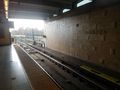
Waitin for the subway
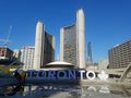
City hall, and that sign that tourists take pictures of. It's me, I'm tourists.
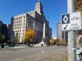
I have always liked this monument at Queen and University. Never bothered to find out what it is. Hope it's not too colonialist!
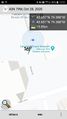
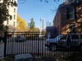
Got to the hashpoint. I am actually there; the GPS is lying
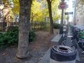
Here is a picture of the hashpoint, containing such sights as "tree" and "bike share"
Here is a picture of the monument. Also, I just looked it up and it's super colonialist so......... oops
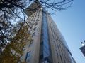
Here is a picture of the building that messed up my GPS reception. Screw you, building! Nah, just kidding, it's fine.
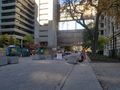
North along Simcoe Street.
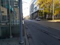
Waitin for the streetcar


Achievements
Frogman earned the Public transport geohash achievement
|