Difference between revisions of "2020-11-24 62 30"
(Created page with "{{subst:Expedition}}") |
|||
| Line 1: | Line 1: | ||
| − | + | {{meetup graticule | |
| − | |||
| − | |||
| − | |||
| − | |||
| − | |||
| − | |||
| − | |||
| − | |||
| lat={{#explode:{{SUBPAGENAME}}| |1}} | | lat={{#explode:{{SUBPAGENAME}}| |1}} | ||
| lon={{#explode:{{SUBPAGENAME}}| |2}} | | lon={{#explode:{{SUBPAGENAME}}| |2}} | ||
| date={{#explode:{{SUBPAGENAME}}| |0}} | | date={{#explode:{{SUBPAGENAME}}| |0}} | ||
| − | }} | + | }} |
__NOTOC__ | __NOTOC__ | ||
== Location == | == Location == | ||
| − | + | At the southern side of Louhivaara hill near Jakokoski, Kontiolahti. | |
| + | |||
| + | The point on a topographic map: [https://asiointi.maanmittauslaitos.fi/karttapaikka/?lang=en&share=customMarker&n=6964785.2&e=653309.4&title=Geohash+2020-11-24+62+30&desc=&zoom=10] | ||
== Participants == | == Participants == | ||
| − | + | * [[User:Kripakko|Kripakko]] | |
| − | |||
| − | == | + | == Expedition == |
| − | + | After missing the hashpoints on Saturday and Sunday due to having better things to do, I wanted to have a go at this one. I also got the idea to visit several geocaches on the way and to take a longer route back home, which would likely take at least six hours to do. The problem is that the days up here are very short (at these coordinates, sunrise is at 8:52 and sunset at 14:41), so I would have to wake up and leave early or ride much of the time in darkness. The first one was never going to happen, and indeed I left at about one o'clock. I would still hopefully be able to reach the hashpoint before dusk and to take nice photos on the way. | |
| − | + | I rode along the shortest way to the hashpoint, stopping at three geocaches and the point where the gravel road crossed the 30° meridian. Of course, I also could not resist stopping to take a few photos while I still could. I entered a smaller gravel road and an even smaller forest road which eventually narrowed so that I had to walk the last 380 metres or so. The moment of sunset came and went, and the night started to darken slowly. I had no trouble walking especially in places with snow on the ground, but the amount of light was insufficient for my camera, something I did not remember to consider beforehand. The photos did not turn out too great, but they were better than nothing. | |
| − | |||
| − | + | I was just barely able to walk back to the bicycle without a lamp, and afterwards I needed it for all the geocache hunting when it really got dark. I cycled back home via 13 geocaches and a grocery store and returned to home just before eight o'clock. The whole trip took about seven hours, and I ended up cycling 58.6 kilometres and walking about a kilometre in total. | |
| − | |||
== Photos == | == Photos == | ||
| − | < | + | <gallery perrow="6"> |
| − | Image:2020- | + | Image:2020-11-24_62_30_01-road1.jpg | The snowy gravel road near Kantelesärkkä. |
| − | -- | + | Image:2020-11-24_62_30_02-jakokoski.jpg | Landscape near Jakokoski. |
| − | + | Image:2020-11-24_62_30_03-30e1.jpg | My GPS receiver at E 30°. | |
| + | Image:2020-11-24_62_30_04-30e2.jpg | The bicycle at E 30°. | ||
| + | Image:2020-11-24_62_30_05-road2.jpg | Kankivaarantie road with quite a bit of snow. | ||
| + | Image:2020-11-24_62_30_06-road3.jpg | The last forest road entering the woods. | ||
| + | Image:2020-11-24_62_30_07-road4.jpg | The same road, a bit later. | ||
| + | Image:2020-11-24_62_30_08-gpsr1.jpg | Hashpoint reached! Proof of location. | ||
| + | Image:2020-11-24_62_30_09-gpsr2.jpg | Proof of date. | ||
| + | Image:2020-11-24_62_30_10-selfie.jpg | Attempt at a selfie with flash at the hashpoint. | ||
| + | Image:2020-11-24_62_30_11-snow.jpg | Falling snow is beautiful in the light of the camera's flash. | ||
</gallery> | </gallery> | ||
== Achievements == | == Achievements == | ||
{{#vardefine:ribbonwidth|800px}} | {{#vardefine:ribbonwidth|800px}} | ||
| − | + | {{land geohash | latitude = 62 | longitude = 30 | date = 2020-11-24 | name = Kripakko }} | |
| − | + | {{bicycle geohash | latitude = 62 | longitude = 30 | date = 2020-11-24 | name = Kripakko | distance = 58.6 km | bothways = true }} | |
| − | |||
| − | |||
| − | |||
| − | |||
| − | |||
| − | |||
| − | |||
| − | |||
| − | |||
| − | |||
| − | |||
| − | |||
| − | |||
[[Category:Expeditions]] | [[Category:Expeditions]] | ||
| − | |||
[[Category:Expeditions with photos]] | [[Category:Expeditions with photos]] | ||
| − | |||
| − | |||
| − | |||
| − | |||
| − | |||
[[Category:Coordinates reached]] | [[Category:Coordinates reached]] | ||
| − | |||
| − | |||
| − | |||
| − | |||
| − | |||
| − | |||
| − | |||
| − | |||
| − | |||
| − | |||
| − | |||
| − | |||
| − | |||
| − | |||
| − | |||
| − | |||
| − | |||
| − | |||
Revision as of 23:16, 24 November 2020
| Tue 24 Nov 2020 in 62,30: 62.7811765, 30.0050230 geohashing.info google osm bing/os kml crox |
Location
At the southern side of Louhivaara hill near Jakokoski, Kontiolahti.
The point on a topographic map: [1]
Participants
Expedition
After missing the hashpoints on Saturday and Sunday due to having better things to do, I wanted to have a go at this one. I also got the idea to visit several geocaches on the way and to take a longer route back home, which would likely take at least six hours to do. The problem is that the days up here are very short (at these coordinates, sunrise is at 8:52 and sunset at 14:41), so I would have to wake up and leave early or ride much of the time in darkness. The first one was never going to happen, and indeed I left at about one o'clock. I would still hopefully be able to reach the hashpoint before dusk and to take nice photos on the way.
I rode along the shortest way to the hashpoint, stopping at three geocaches and the point where the gravel road crossed the 30° meridian. Of course, I also could not resist stopping to take a few photos while I still could. I entered a smaller gravel road and an even smaller forest road which eventually narrowed so that I had to walk the last 380 metres or so. The moment of sunset came and went, and the night started to darken slowly. I had no trouble walking especially in places with snow on the ground, but the amount of light was insufficient for my camera, something I did not remember to consider beforehand. The photos did not turn out too great, but they were better than nothing.
I was just barely able to walk back to the bicycle without a lamp, and afterwards I needed it for all the geocache hunting when it really got dark. I cycled back home via 13 geocaches and a grocery store and returned to home just before eight o'clock. The whole trip took about seven hours, and I ended up cycling 58.6 kilometres and walking about a kilometre in total.
Photos
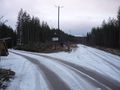
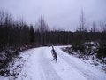
The snowy gravel road near Kantelesärkkä.
Landscape near Jakokoski.
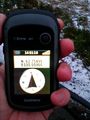
My GPS receiver at E 30°.
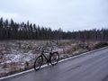
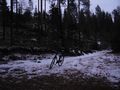
The bicycle at E 30°.
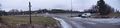
Kankivaarantie road with quite a bit of snow.
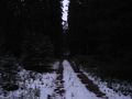
The last forest road entering the woods.
The same road, a bit later.
Hashpoint reached! Proof of location.
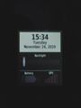
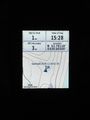
Proof of date.
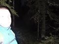
Attempt at a selfie with flash at the hashpoint.
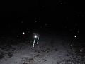
Falling snow is beautiful in the light of the camera's flash.


Achievements
Kripakko earned the Land geohash achievement
|
Kripakko earned the Bicycle geohash achievement
|