Difference between revisions of "2020-12-29 49 8"
(Expedition report) |
|||
| Line 1: | Line 1: | ||
| − | + | [[Image:{{{image|2020-12-29 49 8 Christmas.JPG}}}|thumb|left]] | |
| − | + | {{meetup graticule | |
| − | [[Image:{{{image| | ||
| − | |||
| − | |||
| − | |||
| − | |||
| − | |||
| − | |||
| lat=49 | | lat=49 | ||
| lon=8 | | lon=8 | ||
| date=2020-12-29 | | date=2020-12-29 | ||
| − | }} | + | }} |
__NOTOC__ | __NOTOC__ | ||
| Line 37: | Line 30: | ||
The nearby Gutenbrunnen (Good Fountain) and Heilbrunnen (Healing Fountain) seemed to be overbuilt natural springs. | The nearby Gutenbrunnen (Good Fountain) and Heilbrunnen (Healing Fountain) seemed to be overbuilt natural springs. | ||
At the Gutenbrunnen, we found an obelisk, probably a war memorial, judging by the heardly visible inscription. | At the Gutenbrunnen, we found an obelisk, probably a war memorial, judging by the heardly visible inscription. | ||
| − | The Lourdes grotto was a simple artificial grotto, just large enough for | + | The Lourdes grotto was a simple artificial grotto, just large enough for two figures and some candles |
There was also a decorated Christmas tree in front of it. | There was also a decorated Christmas tree in front of it. | ||
| Line 48: | Line 41: | ||
== Photos == | == Photos == | ||
| − | |||
| − | |||
| − | |||
| − | |||
| − | |||
<gallery perrow="5"> | <gallery perrow="5"> | ||
| + | File:2020-12-29 49 8 Clearing.JPG | The location | ||
| + | File:2020-12-29 49 8 Feet.JPG | At the hash point | ||
| + | File:2020-12-29 49 8 Proof.png | Proof | ||
| + | File:2020-12-29 49 8 Hat.JPG | The hat was there | ||
| + | File:2020-12-29 49 8 Obelisk.JPG | Looks like a war memorial | ||
| + | File:2020-12-29 49 8 Gutenbrunnen.JPG | Gutenbrunnen | ||
| + | File:2020-12-29 49 8 Mary.JPG | Lourdes grotto | ||
| + | File:2020-12-29 49 8 Christmas.JPG | A Christmas tree | ||
</gallery> | </gallery> | ||
| Line 59: | Line 55: | ||
{{#vardefine:ribbonwidth|800px}} | {{#vardefine:ribbonwidth|800px}} | ||
<!-- Add any achievement ribbons you earned below, or remove this section --> | <!-- Add any achievement ribbons you earned below, or remove this section --> | ||
| − | |||
| − | |||
| − | |||
| − | |||
| − | |||
| − | |||
| − | |||
| − | |||
| − | |||
| − | |||
| − | |||
[[Category:Expeditions]] | [[Category:Expeditions]] | ||
[[Category:Coordinates reached]] | [[Category:Coordinates reached]] | ||
| − | |||
| − | |||
| − | |||
| − | |||
| − | |||
[[Category:Expeditions with photos]] | [[Category:Expeditions with photos]] | ||
| − | |||
| − | |||
| − | |||
| − | |||
| − | |||
| − | |||
| − | |||
| − | |||
| − | |||
| − | |||
| − | |||
| − | |||
| − | |||
| − | |||
| − | |||
| − | |||
| − | |||
| − | |||
| − | |||
| − | |||
| − | |||
| − | |||
| − | |||
Revision as of 08:28, 30 December 2020

| Tue 29 Dec 2020 in 49,8: 49.0333474, 8.1585858 geohashing.info google osm bing/os kml crox |
Location
In the Bienwald near Büchelberg.
Participants
Plans
Take the car to some forestry road, walk from there, explore the nearby Gutenbrunnen, Heilbrunnen and Lourdes grotto.
Expedition
We found the forestry track and a spot to park the car and walked into the forest. From there, it was just over 1 km to the location. It was some 30 m off the track, but fortunately, there was a clearing in the forest so that it was quite easy to reach. We took some pictures and left again.
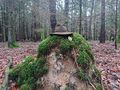
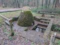
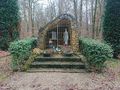
The nearby Gutenbrunnen (Good Fountain) and Heilbrunnen (Healing Fountain) seemed to be overbuilt natural springs. At the Gutenbrunnen, we found an obelisk, probably a war memorial, judging by the heardly visible inscription. The Lourdes grotto was a simple artificial grotto, just large enough for two figures and some candles There was also a decorated Christmas tree in front of it.
On the way back, we had to cross the Heilbach. I had anticipated a river crossing of some sort where OpenStreetMap showed a gap in the path. But it turned out that the map was indeed right and there was no bridge. Fortunately, we found a spot where some branches and debris in the creek allowed us to cross without getting our feet wet. We reached the car just before it startet raining and drove home.
Photos
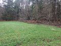
The location
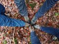
At the hash point
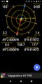
Proof
The hat was there

Looks like a war memorial
Gutenbrunnen
Lourdes grotto
A Christmas tree


