Difference between revisions of "2021-02-01 62 29"
(Created page with "{{subst:Expedition}}") |
|||
| Line 1: | Line 1: | ||
| − | + | {{meetup graticule | |
| − | |||
| − | |||
| − | |||
| − | |||
| − | |||
| − | |||
| − | |||
| − | |||
| lat={{#explode:{{SUBPAGENAME}}| |1}} | | lat={{#explode:{{SUBPAGENAME}}| |1}} | ||
| lon={{#explode:{{SUBPAGENAME}}| |2}} | | lon={{#explode:{{SUBPAGENAME}}| |2}} | ||
| date={{#explode:{{SUBPAGENAME}}| |0}} | | date={{#explode:{{SUBPAGENAME}}| |0}} | ||
| − | }} | + | }} |
__NOTOC__ | __NOTOC__ | ||
== Location == | == Location == | ||
| − | + | In a young sparse forest at the southern edge of Jaamankangas. | |
| + | |||
| + | The point on a topographic map: [https://asiointi.maanmittauslaitos.fi/karttapaikka/?lang=en&share=customMarker&n=6952212.6&e=641580.3&title=Geohash+2021-02-01+62+29&desc=&zoom=10] | ||
== Participants == | == Participants == | ||
| − | + | * [[User:Kripakko|Kripakko]] | |
| − | + | ||
| + | == Expedition == | ||
| + | The hashpoints have ended up in too distant locations during the past weeks. I do not want to cycle long distances when it is freezing, and now that the snow cover is more than half a metre thick, getting anywhere off-road on foot is difficult. This one was near enough and reasonably close to a road, so I went for it. I reinflated my studded bicycle tyres from the old ~2.5 bar to 4 bar, which may have been a mistake in hindsight, and began cycling towards Lehmo and Jaamankangas. | ||
| + | |||
| + | Everything went well as long as I could ride on cycleways. As much as I like to bitch about bad road maintenance in winter, at least they are covered in somewhat consistent layer of snow that offers sufficient grip. Well, as long as there is no slippery ice immediately underneath, which is not the case now since there has been a significant amount of snowfall after the last thaw. In contrast, the last 900 metres that I had to ride on Jaamankankaantie road were the most treacherous because the road was covered partly in slippery ice and partly in very uneven frozen snow. Although the bicycle was lighter to ride with the higher tyre pressures, the grip was more unstable especially on this slippery road. I almost fell once when the front tyre ended up in an invisible groove and did not obey my steering, and after that I rode very calmly and carefully. | ||
| − | + | I left the road at the intersection of the pet cemetery and parked the bicycle at the side of the driveway of the house. Then I had to walk the last 150 metres in deep almost untouched snow, touched only by a few hare tracks. The depth of the snow in the semi-open area was about 60 cm, consisting of 35 cm of old snow, 15 cm of strong frozen snow and 10 cm of fresh powder snow. I only sank to the depth of about 50 cm however because the snow was compressed under my feet. Also, sometimes the frozen snow could support my weight and I would sink only less than 10 cm, but mostly it did not. I wish that I had skis or snowshoes with me – with either of those, I could have easily glided or walked on the surface. | |
| − | |||
| − | + | I eventually reached the hashpoint and took photos for proof. I brought a thermometer so that I could record the temperature. It showed −8 °C which is at the extreme lower end of the scale. It is technically an inside thermometer intended for measuring room temperature, but since the reading is consistent with local weather forecasts, I trust it. I left soon before I would be freezing from standing still. My hands had already started to feel cold from handling my equipment with bare hands (apparently you cannot use a touch screen with leather gloves, argh), but it was not yet too much. I walked back to the bicycle and cycled back home. | |
| − | |||
| − | + | I cycled 18.1 km and walked 0.5 km during the trip. The extra walking distance comes from me having to walk a part of the way that is a walkway and illegal to cycle. | |
| − | |||
== Photos == | == Photos == | ||
| − | < | + | <gallery perrow="4"> |
| − | Image: | + | Image:2021-02-01_62_29_01-road.jpg | Jaamamkankaantie road covered in ice and snow and light blizzard in the air that looks like fog. |
| − | -- | + | Image:2021-02-01_62_29_02-petcemetery.jpg | View to the pet cemetery from the other side of the road. |
| − | + | Image:2021-02-01_62_29_03-bicycle.jpg | Where I parked the bicycle, 150 metres to go. | |
| + | Image:2021-02-01_62_29_04-selfie.jpg | Selfie at the hashpoint, which was at this group of birch trees. | ||
| + | Image:2021-02-01_62_29_05-gpsr1.jpg | Proof of location. | ||
| + | Image:2021-02-01_62_29_06-gpsr2.jpg | Proof of date and time. | ||
| + | Image:2021-02-01_62_29_07-thermometer.jpg | Proof of temperature. | ||
| + | Image:2021-02-01_62_29_08-gpsr3.jpg | Bonus: GPS receiver blooper – Time/status and map screens superimposed in the photo. The automatic screen transition occurred during the 50-millisecond exposure time. | ||
</gallery> | </gallery> | ||
== Achievements == | == Achievements == | ||
{{#vardefine:ribbonwidth|800px}} | {{#vardefine:ribbonwidth|800px}} | ||
| − | + | {{land geohash | latitude = 62 | longitude = 29 | date = 2021-02-01 | name = Kripakko}} | |
| − | + | {{bicycle geohash | latitude = 62 | longitude = 29 | date = 2021-02-01 | name = Kripakko | distance = 18.1 km | bothways = true}} | |
| − | + | {{Frozen Geohash | latitude = 62 | longitude = 29 | date = 2021-02-01 | name = Kripakko | temperature = −8 °C }} | |
| − | |||
| − | |||
| − | |||
| − | |||
| − | |||
| − | |||
| − | |||
| − | |||
| − | |||
| − | |||
| − | |||
| − | |||
[[Category:Expeditions]] | [[Category:Expeditions]] | ||
| − | |||
[[Category:Expeditions with photos]] | [[Category:Expeditions with photos]] | ||
| − | |||
| − | |||
| − | |||
| − | |||
| − | |||
[[Category:Coordinates reached]] | [[Category:Coordinates reached]] | ||
| − | |||
| − | |||
| − | |||
| − | |||
| − | |||
| − | |||
| − | |||
| − | |||
| − | |||
| − | |||
| − | |||
| − | |||
| − | |||
| − | |||
| − | |||
| − | |||
| − | |||
| − | |||
Revision as of 02:37, 3 February 2021
| Mon 1 Feb 2021 in 62,29: 62.6731810, 29.7648907 geohashing.info google osm bing/os kml crox |
Location
In a young sparse forest at the southern edge of Jaamankangas.
The point on a topographic map: [1]
Participants
Expedition
The hashpoints have ended up in too distant locations during the past weeks. I do not want to cycle long distances when it is freezing, and now that the snow cover is more than half a metre thick, getting anywhere off-road on foot is difficult. This one was near enough and reasonably close to a road, so I went for it. I reinflated my studded bicycle tyres from the old ~2.5 bar to 4 bar, which may have been a mistake in hindsight, and began cycling towards Lehmo and Jaamankangas.
Everything went well as long as I could ride on cycleways. As much as I like to bitch about bad road maintenance in winter, at least they are covered in somewhat consistent layer of snow that offers sufficient grip. Well, as long as there is no slippery ice immediately underneath, which is not the case now since there has been a significant amount of snowfall after the last thaw. In contrast, the last 900 metres that I had to ride on Jaamankankaantie road were the most treacherous because the road was covered partly in slippery ice and partly in very uneven frozen snow. Although the bicycle was lighter to ride with the higher tyre pressures, the grip was more unstable especially on this slippery road. I almost fell once when the front tyre ended up in an invisible groove and did not obey my steering, and after that I rode very calmly and carefully.
I left the road at the intersection of the pet cemetery and parked the bicycle at the side of the driveway of the house. Then I had to walk the last 150 metres in deep almost untouched snow, touched only by a few hare tracks. The depth of the snow in the semi-open area was about 60 cm, consisting of 35 cm of old snow, 15 cm of strong frozen snow and 10 cm of fresh powder snow. I only sank to the depth of about 50 cm however because the snow was compressed under my feet. Also, sometimes the frozen snow could support my weight and I would sink only less than 10 cm, but mostly it did not. I wish that I had skis or snowshoes with me – with either of those, I could have easily glided or walked on the surface.
I eventually reached the hashpoint and took photos for proof. I brought a thermometer so that I could record the temperature. It showed −8 °C which is at the extreme lower end of the scale. It is technically an inside thermometer intended for measuring room temperature, but since the reading is consistent with local weather forecasts, I trust it. I left soon before I would be freezing from standing still. My hands had already started to feel cold from handling my equipment with bare hands (apparently you cannot use a touch screen with leather gloves, argh), but it was not yet too much. I walked back to the bicycle and cycled back home.
I cycled 18.1 km and walked 0.5 km during the trip. The extra walking distance comes from me having to walk a part of the way that is a walkway and illegal to cycle.
Photos
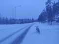
Jaamamkankaantie road covered in ice and snow and light blizzard in the air that looks like fog.
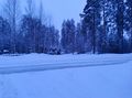
View to the pet cemetery from the other side of the road.
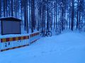
Where I parked the bicycle, 150 metres to go.
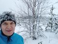
Selfie at the hashpoint, which was at this group of birch trees.
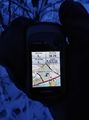
Proof of location.
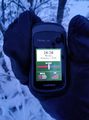
Proof of date and time.
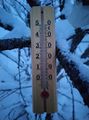
Proof of temperature.
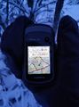
Bonus: GPS receiver blooper – Time/status and map screens superimposed in the photo. The automatic screen transition occurred during the 50-millisecond exposure time.


Achievements
Kripakko earned the Land geohash achievement
|
Kripakko earned the Bicycle geohash achievement
|
Kripakko earned the Frozen Geohash Achievement
|