Difference between revisions of "1973-05-26 42 -83"
From Geohashing
imported>Tjtrumpet2323 m (adding new "retro" parameter for Template:Meetup graticule) |
imported>Benjw (wrong photo used in gallery; re-catting) |
||
| Line 19: | Line 19: | ||
<gallery> | <gallery> | ||
Image:1973-05-26_42_-83-GPS.jpg | GPS reading rounded to 3 decimal places | Image:1973-05-26_42_-83-GPS.jpg | GPS reading rounded to 3 decimal places | ||
| − | Image: | + | Image:1973-05-26 42 -83 Bill.jpg | Picture of me at my origin geohash location. Whee! |
</gallery> | </gallery> | ||
[[Category:Expeditions]] | [[Category:Expeditions]] | ||
[[Category:Expeditions with photos]] | [[Category:Expeditions with photos]] | ||
| − | [[Category:Origin | + | [[Category:Origin geohash achievement]] |
Revision as of 08:22, 19 May 2009
| Sat 26 May 1973 in 42,-83: 42.6626130, -83.3441705 geohashing.info google osm bing/os kml crox |
About
The location for my Origin Achievement is in Waterford Oaks Park, two miles northeast of the 2008-06-28 42 -83 Detroit Saturday Meetup.
Plan
Bill^2: Planned on doing this one on Thursday 6/26, but got delayed by rain. This was just as well, as the location ended up being only two miles from the Saturday meetup.
Pictures
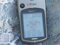
GPS reading rounded to 3 decimal places

Picture of me at my origin geohash location. Whee!

