Difference between revisions of "2021-04-01 49 8"
Gefrierbrand (talk | contribs) (Created page with "{{meetup graticule | lat=49 | lon=8 | date=2021-04-01 }} __NOTOC__ == Location == The hashpoint is located on a meadow next to Unter-Ostern. On the map it seems to be one of...") |
Gefrierbrand (talk | contribs) |
||
| Line 24: | Line 24: | ||
== Photos == | == Photos == | ||
<gallery perrow="5"> | <gallery perrow="5"> | ||
| − | + | File:2021-04-01 49-8 Pedro.jpg | Watchman Pedro | |
| − | + | File:2021-04-01 49-8 Grin.jpg | Stupid Grin <sup>TM</sup> | |
| − | + | File:2021-04-01 49-8 Ice.jpg | Ice cream at Rodenstein | |
| − | + | File:2021-04-01 49-8 Proof.jpg | Proof | |
| − | + | File:2021-04-01 49-8 Twister.JPG | Twister with Pedro | |
| − | |||
</gallery> | </gallery> | ||
== Achievements == | == Achievements == | ||
{{#vardefine:ribbonwidth|800px}} | {{#vardefine:ribbonwidth|800px}} | ||
| − | |||
| − | {{ | + | {{twister geohash |
| − | | latitude = | + | | latitude = 49 |
| − | | longitude = | + | | longitude = 8 |
| − | | date = | + | | date = 2021-04-01 |
| − | | name = | + | | name = Santu & Gefrierbrand |
| − | |||
| − | |||
}} | }} | ||
| − | + | {{land geohash | |
| − | + | | latitude = 49 | |
| + | | longitude = 8 | ||
| + | | date = 2021-04-01 | ||
| + | | name = Santu & Gefrierbrand | ||
| + | }} | ||
| − | |||
| − | |||
| − | |||
| − | |||
| − | |||
[[Category:Expeditions]] | [[Category:Expeditions]] | ||
| − | |||
| − | |||
[[Category:Expeditions with photos]] | [[Category:Expeditions with photos]] | ||
| − | |||
| − | |||
| − | |||
| − | |||
| − | |||
[[Category:Coordinates reached]] | [[Category:Coordinates reached]] | ||
| − | |||
| − | |||
| − | |||
| − | |||
| − | |||
| − | |||
| − | |||
| − | |||
| − | |||
| − | |||
| − | |||
| − | |||
| − | |||
| − | |||
| − | |||
| − | |||
| − | |||
| − | |||
| − | |||
| − | |||
| − | |||
Revision as of 20:33, 4 April 2021
| Thu 1 Apr 2021 in 49,8: 49.6924794, 8.8673931 geohashing.info google osm bing/os kml crox |
Location
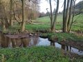
The hashpoint is located on a meadow next to Unter-Ostern. On the map it seems to be one of the easy to reach hashes.
Participants
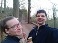
Santu Gefrierbrand Pedro the dog
Plans
Our evaluation of the today's geohashing circumstances gave reason to aim for more than a simple "Been there"-hash. So we decided to take the twister board and playing field with us. Furthermore, we decided to approach the hashpoint from the south to take up the challenge of crossing a small creek on our way. Besides this direct hash-related plans we also planned to get some ice cream at the next best ice-cream parlor and visit Rodenstein castle near Eberbach as well as the Fallbach falls in close proximity to the castle.
Expedition
After having finished the work on our current DIY project, we set off for geohashing (therefore the work clothes). We went to Unter-Ostern by car and went down to the creek. After a quick inspection we found some barbed wire in the surrounding and thus decided to leave Pedro tethered up on the meadow so he wouldn't hurt his paws. The crossing of the creek was unspectacular and we were lucky as the hashpoint was easily accessible and not in the midst of the nearby brambles. Pedro had an eye on us for the whole time in order to take all necessary steps to guard his feed suppliers. Wen didn't want to let him wait for to long for us, so we decided to cross the creek again before starting the twister game. With Pedro among us it was quite a challenge to stay on the playing field as he tends to scramble and lick whenever human skin is within reach.
After having accomplished the hash we went on towards Rodenstein castle. On out way we found the ice cream parlor and did a quick pit stop there. Some minutes walk from the castle we visited Fallbach falls and then headed back home right in time before it got to dark to roam the woods without a flashlight.
Photos
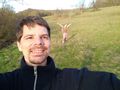
Watchman Pedro
Stupid Grin TM
Ice cream at Rodenstein
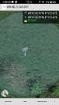
Proof

Twister with Pedro


Achievements
Santu & Gefrierbrand earned the Twister Geohash Achievement
|
Santu & Gefrierbrand earned the Land geohash achievement
|