Difference between revisions of "2021-04-10 62 29"
From Geohashing
(Created page with "{{Subst:Expedition}}") |
|||
| Line 1: | Line 1: | ||
| − | + | {{meetup graticule | |
| − | |||
| − | |||
| − | |||
| − | |||
| − | |||
| − | |||
| − | |||
| − | |||
| lat={{#explode:{{SUBPAGENAME}}| |1}} | | lat={{#explode:{{SUBPAGENAME}}| |1}} | ||
| lon={{#explode:{{SUBPAGENAME}}| |2}} | | lon={{#explode:{{SUBPAGENAME}}| |2}} | ||
| date={{#explode:{{SUBPAGENAME}}| |0}} | | date={{#explode:{{SUBPAGENAME}}| |0}} | ||
| − | }} | + | }} |
__NOTOC__ | __NOTOC__ | ||
== Location == | == Location == | ||
| − | + | At the northern side of the Utranharju ridge. | |
| + | |||
| + | The point on a topographic map: [https://asiointi.maanmittauslaitos.fi/karttapaikka/?lang=en&share=customMarker&n=6948777.3&e=647212.0&title=Geohash+2021-04-10+62+29&desc=&zoom=10] | ||
== Participants == | == Participants == | ||
| − | + | * [[User:Kripakko|Kripakko]] | |
| − | |||
| − | == | + | == Expedition == |
| − | + | Veni, vidi, vici. | |
| − | + | Full text will follow... | |
| − | |||
| − | + | <!-- cycle 13.5 km, walk 1.2 km --> | |
| − | <!-- | ||
== Photos == | == Photos == | ||
| − | + | ||
| − | |||
| − | |||
<gallery perrow="5"> | <gallery perrow="5"> | ||
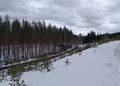
| + | Image:2021-04-10_62_29_01-river.jpg | The Pielisjoki river near the Utra islands. | ||
| + | Image:2021-04-10_62_29_02-bicycle.jpg | Where I parked the bicycle, 290 metres to go as the crow flies. | ||
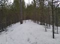
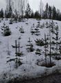
| + | Image:2021-04-10_62_29_03-skitrack.jpg | How the ski track looks now, not nice. | ||
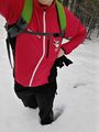
| + | Image:2021-04-10_62_29_04-selfie.jpg | Selfie at the hashpoint. | ||
| + | Image:2021-04-10_62_29_05-gpsr1.jpg | Proof of location. | ||
| + | Image:2021-04-10_62_29_06-gpsr2.jpg | Proof of date. | ||
| + | Image:2021-04-10_62_29_07-footprints.jpg | My footprints in the snow, looking back to the hashpoint. | ||
| + | Image:2021-04-10_62_29_08-kneedeep.jpg | Standing almost knee-deep in the snow. | ||
| + | Image:2021-04-10_62_29_09-downhill.jpg | View down the ridgeside, you can see the muddy road up close and the paved road in the distance. | ||
| + | Image:2021-04-10_62_29_10-uphill.jpg | View back up to where I just came from with a visible buttslide track in the snow. | ||
</gallery> | </gallery> | ||
== Achievements == | == Achievements == | ||
{{#vardefine:ribbonwidth|800px}} | {{#vardefine:ribbonwidth|800px}} | ||
| − | |||
| − | |||
| − | |||
| − | |||
| − | |||
| − | |||
| − | |||
| − | |||
| − | |||
| − | |||
| − | |||
| − | |||
| − | + | {{land geohash | name = Kripakko | latitude = 62 | longitude = 29 | date = 2021-04-10}} | |
| + | {{bicycle geohash | name = Kripakko | latitude = 62 | longitude = 29 | date = 2021-04-10 | distance = 13.5 km | bothways = true}} | ||
| − | |||
[[Category:Expeditions]] | [[Category:Expeditions]] | ||
| − | |||
[[Category:Expeditions with photos]] | [[Category:Expeditions with photos]] | ||
| − | |||
| − | |||
| − | |||
| − | |||
| − | |||
[[Category:Coordinates reached]] | [[Category:Coordinates reached]] | ||
| − | |||
| − | |||
| − | |||
| − | |||
| − | |||
| − | |||
| − | |||
| − | |||
| − | |||
| − | |||
| − | |||
| − | |||
| − | |||
| − | |||
| − | |||
| − | |||
| − | |||
| − | |||
Revision as of 21:58, 10 April 2021
| Sat 10 Apr 2021 in 62,29: 62.6401767, 29.8717236 geohashing.info google osm bing/os kml crox |
Location
At the northern side of the Utranharju ridge.
The point on a topographic map: [1]
Participants
Expedition
Veni, vidi, vici.
Full text will follow...
Photos
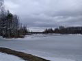
The Pielisjoki river near the Utra islands.
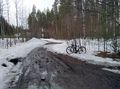
Where I parked the bicycle, 290 metres to go as the crow flies.
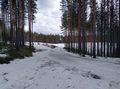
How the ski track looks now, not nice.
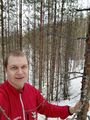
Selfie at the hashpoint.
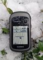
Proof of location.
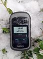
Proof of date.
My footprints in the snow, looking back to the hashpoint.
Standing almost knee-deep in the snow.
View down the ridgeside, you can see the muddy road up close and the paved road in the distance.
View back up to where I just came from with a visible buttslide track in the snow.


Achievements
Kripakko earned the Land geohash achievement
|
Kripakko earned the Bicycle geohash achievement
|