Difference between revisions of "2021-04-11 49 8"
Gefrierbrand (talk | contribs) |
Gefrierbrand (talk | contribs) |
||
| Line 71: | Line 71: | ||
}} | }} | ||
| − | |||
| − | |||
| − | |||
| − | |||
| − | |||
| − | |||
| − | |||
| − | |||
| − | |||
| − | |||
| − | |||
| − | |||
| − | |||
| − | |||
[[Category:Expeditions]] | [[Category:Expeditions]] | ||
| − | |||
[[Category:Expeditions with photos]] | [[Category:Expeditions with photos]] | ||
| − | |||
| − | |||
| − | |||
| − | |||
| − | |||
[[Category:Coordinates reached]] | [[Category:Coordinates reached]] | ||
| − | |||
| − | |||
| − | |||
| − | |||
| − | |||
| − | |||
| − | |||
| − | |||
| − | |||
| − | |||
| − | |||
| − | |||
| − | |||
| − | |||
| − | |||
| − | |||
| − | |||
| − | |||
Revision as of 10:30, 12 April 2021
| Sun 11 Apr 2021 in 49,8: 49.6865853, 8.6324570 geohashing.info google osm bing/os kml crox |
Location
In a vineyard near Bensheim
Participants
- Gefrierbrand
- Santu
- Pedro the dog
Plans
We intended to use the train and travel to Auerbach, walk through the Fürstenlager towards the hash and then to Bensheim and return from there.
Expedition
First, we prepared pizza bread, dried tangerines, mini salami, fruit salad and other small snacks as well as some treats for the dog for our later picnic. We then used two Buslines to get tho Darmstadts Central Station and then took the train towards Bensheim. Pedro was very brave and patient during this even though he tried to exit at each and every station we encountered.
Having arrived in Auerbach, we first looked around a bit and wandered of in the general direction of the Fürstenlager. But as we noticed the nice castle on top of the nearby hill, we pondered if going there would be feasible. Hiking up there would lengthen the trip by about 2 kilometers in distance and an unknown but probably large amount in height. But we would most likely be able reach it and to still do all other planned activities before the predicted rain would start. We therefore changed plans and hiked up to the Castle Auerbach.
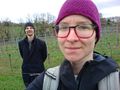
Unfortunately, the gate was closed and we could not enter the castle. But there was a small pathway around the entire walls. We ventured along and had our first picnic with a nice view away from most of the other tourists who stayed near the parking space. Sadly, Gefrierbrand had forgotten his binoculars and therefore could not identify the high-rising buildings in the distance with certainty, but we still enjoyed the view.
Continuing, we traveled back downhill, which was much less strenuous. We then followed the signs towards the Fürstenlager along small winding roads with old houses and independent stores. After arriving there we explored the area a bit, took pictures near the "Healty well" and relished in the really nice grounds. There were several viewpoints, aviaries and gazebos.
Then it was time to proceed towards the hashlocation which was about 1km away. We misjudge the distance and traveld further than anticipated. We only noticed this when we stood in front of a strange garden and were unsure which path to take next only to discover that returning back was necessary. Good thing we weren't trying for a tron route.
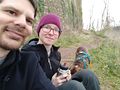
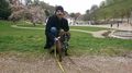
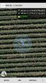
Locating the Hashpoint in the vineyard required us to enter the rows, look a the GPS, return back and move along a few rows and enter it again since travelling between the rows was not really possible due to the tensioned wires holding up the vines, but we managed to get there relatively quickly. Time for the second, proper picnic at the hashlocation!
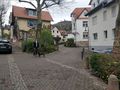
After we had strengthened ourselves, we could continue walking towards Bensheim. The most direct route was also the most adventurous one: a narrow, steep and overgrown trail wriggled itself downhill, and we along it. Subsequently, we explored Bensheims city center and discovered a very old (probably built in 1395) and slightly crooked half-timbered house along the way.
Despite the cold weather, Gefrierbrand then also devoured an icecream before we all returned back home via trains, trams and buses. We barely made it inside without getting wet.
Photos
Schloss Auerbach in the Background
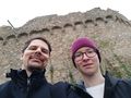
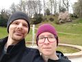
Us with castle walls
fist picnic at Schloss Auerbach
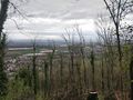
view from the hill
fauntain in Fürstenlager
View on "Healthy Well"
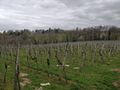
Overview of the hashcontaining vineyard
second picnic at hashlocation
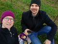
StupidGrinTM
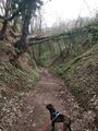
interesting way back
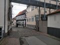
very crooked old, half-timbered house
Proof


Achievements
Santu & Gefrierbrand earned the Land geohash achievement
|
Santu & Gefrierbrand earned the Public transport geohash achievement
|
Santu & Gefrierbrand earned the Picnic achievement
|