Difference between revisions of "2008-06-30 37 -122"
From Geohashing
imported>Anthony (fix date in template) |
imported>Thomcat (Success/failure category added) |
||
| Line 18: | Line 18: | ||
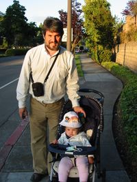
[[Image:Anthony-2008-06-30-37--122.jpg|thumb|left|200px|[[User:Anthony|Anthony]] and daughter at the spot]] | [[Image:Anthony-2008-06-30-37--122.jpg|thumb|left|200px|[[User:Anthony|Anthony]] and daughter at the spot]] | ||
[[User:Anthony|Anthony's]] [http://www.flickr.com/photos/danceslut/sets/72157605909274360/ flickr photos] | [[User:Anthony|Anthony's]] [http://www.flickr.com/photos/danceslut/sets/72157605909274360/ flickr photos] | ||
| + | |||
| + | [[Category:Expeditions]] | ||
| + | [[Category:Expeditions with photos]] | ||
| + | [[Category:Coordinates reached]] | ||
Revision as of 20:01, 11 August 2008
| Mon 30 Jun 2008 in San Francisco: 37.7824335, -122.2748329 geohashing.info google osm bing/os kml crox |
About
These coordinates are located in the San Francisco, California graticule on 2008-06-28, in Alameda.
The official coordinates resolve to 37.782433°, -122.274833° (or N37°46.946', W122°16.4899' or N37°46'56.76", W122°16'29.39"), at the corner of Constitution Way and Marina Village Parkway in Alameda, on the sidewalk.
Anthony reached the point at about 20:01.
Pictures

Anthony and daughter at the spot