Difference between revisions of "2021-11-09 51 9"
(Created page with "{{meetup graticule | lat=51 | lon=9 | date=2021-11-09 }} <!-- edit as necessary --> __NOTOC__ == Location == In a forest near Waldkappel == Participants == User:Digiphon...") |
(→Photos) |
||
| Line 30: | Line 30: | ||
Image:2021-11-01_51_9_001.jpg|On my way to the hash | Image:2021-11-01_51_9_001.jpg|On my way to the hash | ||
Image:2021-11-02_51_9_002.jpg|The hash was in the forest behind this field | Image:2021-11-02_51_9_002.jpg|The hash was in the forest behind this field | ||
| − | Image:2021-11- | + | Image:2021-11-02_51_9_003.jpg|Nice view on Waldkappel, some 100 meters from the hash |
Image:2021-11-04_51_9_004.jpg|A small path almost leading me to the hash | Image:2021-11-04_51_9_004.jpg|A small path almost leading me to the hash | ||
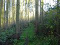
Image:2021-11-05_51_9_005.jpg|Near the hash location - total wildness | Image:2021-11-05_51_9_005.jpg|Near the hash location - total wildness | ||
Revision as of 18:37, 9 November 2021
| Tue 9 Nov 2021 in 51,9: 51.1408996, 9.8773143 geohashing.info google osm bing/os kml crox |
Location
In a forest near Waldkappel
Participants
Plans
Drive to Waldkappel by car after work and go for this hash in the forest...
Expedition
As planned I drove to Waldkappel after work and parked my car at the local swimming area (in summer, it's hard to find a free parking lot, in fall I was the only one around here) and went for a nice walk through the forest. Wanted to do a geocache first and arrived at the coordinates some 15 minutes / 1,5 kilometer later, bit there were some other people enjoying the nice weather right on the bank, where the geocache should've been hidden, so I left this one out and continued my way to todays geohash...
The sun was shining and filled the forest with another thousand of interesting colours, so I enjoyed my walk to the hash. Some 100 meters from the hash I found this nice place with a great view over the village Waldkappel and then a small path almost lead me directly to the hash... Well, almost... The path was surrounded by blackberries - stings and thorns everywhere, and still some 40 meters to go from here. I decided to further walk the path and after some 60 meters I found a 'better' path, sort of leading me back to the geohash... Still extremely overgrown, but less thorns, which was a good alternative.
So, after a little struggle on the final 25 meters I approached the hash - some pines and lots of bushes (never was in the jungle, but I guess this location got quite similar!)... Took some pics for evidence and then walked an alternative route back to my car, drove home and that's it!
Photos

On my way to the hash
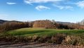
The hash was in the forest behind this field
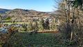
Nice view on Waldkappel, some 100 meters from the hash
A small path almost leading me to the hash

Near the hash location - total wildness
- 2021-11-06 51 9 006.jpg
The hash
- 2021-11-07 51 9 007.jpg
The hasher at the hash location
Proof


