Difference between revisions of "2021-12-02 50 7"
Gefrierbrand (talk | contribs) ([retro picture]church) |
Gefrierbrand (talk | contribs) |
||
| Line 1: | Line 1: | ||
| − | + | {{meetup graticule | |
| − | |||
| − | |||
| − | |||
| − | |||
| − | |||
| − | |||
| − | |||
| − | |||
| lat=50 | | lat=50 | ||
| lon=7 | | lon=7 | ||
| date=2021-12-02 | | date=2021-12-02 | ||
| − | }} | + | }} |
__NOTOC__ | __NOTOC__ | ||
== Location == | == Location == | ||
| − | + | On a field near Wolken next to The A 48 | |
| + | == Participants == | ||
| + | [[User:Gefrierbrand|Gefrierbrand]] | ||
| − | == | + | == Expedition == |
| − | + | The hashlocation was quite near the [https://en.wikipedia.org/wiki/Goloring Goloring] which had me intrigued for quite a while now so I simply had to go hashing. I decided to go by bike and was also initially trying to go for a tron route. While traveling, it was not only cold, wet and dark but also small almost invisible hailstones harshly poked my face for quite a long way. And of course I was going against the wind and uphill. So it was not too surprising that I eventually took a wrong turn and ended up in a dead end and had to trace my way back. | |
| − | |||
| − | + | In the end, I arrived relatively quickly at the has, took proof screenshots, actually forgot the Stupid grin picture and stated to head back. Since tron was no longer possible, I took the opportunity and climbed the nearby hill to maybe get a good view and visit the St. Mary chapel on it. To my surprise, it was not only unlocked, but also had some nice burning candles inside. | |
| − | |||
| − | + | On the way back I took a different route downhill over very slippery and muddy paths constantly wondering where I am since the GPS told me several times to turn where no road or paths were. Obviously I didn't have to pedal as much (sometimes not at all) which meant it got even colder and as I arrived home I was quite freezing despite having planned for the weather and wearing appropriate clothes. So i took a looong hot shower and called it a day. | |
| − | |||
== Tracklog == | == Tracklog == | ||
| − | + | {{tracklog | File:T2021-12-02-17-49.gpx}} | |
== Photos == | == Photos == | ||
| − | |||
| − | |||
| − | |||
<gallery perrow="5"> | <gallery perrow="5"> | ||
| − | + | Image:2021-12-02_50_7_Gefrierbrand_1638543749810.jpg|awesome dark sky | |
| − | Image:2021-12-02_50_7_Gefrierbrand_1638543749810.jpg|dark sky | + | Image:2021-12-02_50_7_Gefrierbrand_1638543811814.jpg|bike in the night |
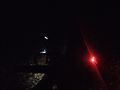
| − | + | Image:2021-12-02_50_7_Gefrierbrand_1638543835045.jpg|dimly lit church | |
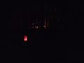
Image:2021-12-02_50_7_Gefrierbrand_1638543787723.jpg|proof | Image:2021-12-02_50_7_Gefrierbrand_1638543787723.jpg|proof | ||
| − | |||
| − | |||
| − | |||
| − | |||
</gallery> | </gallery> | ||
| Line 47: | Line 31: | ||
{{#vardefine:ribbonwidth|800px}} | {{#vardefine:ribbonwidth|800px}} | ||
<!-- Add any achievement ribbons you earned below, or remove this section --> | <!-- Add any achievement ribbons you earned below, or remove this section --> | ||
| + | {{land geohash | ||
| + | | latitude = 50 | ||
| + | | longitude = 7 | ||
| + | | date = 2021-12-02 | ||
| + | | name = Gefrierbrand | ||
| + | }} | ||
| + | {{Drowned rat geohash | ||
| + | | latitude = 50 | ||
| + | | longitude = 7 | ||
| + | | date = 2021-12-02 | ||
| + | | name = Gefrierbrand | ||
| + | | honourable = yes | ||
| + | }} | ||
| + | {{bicycle geohash | ||
| + | | latitude = 50 | ||
| + | | longitude = 7 | ||
| + | | date = 2021-12-02 | ||
| + | | name = Gefrierbrand | ||
| + | }} | ||
| − | |||
| − | |||
| − | |||
| − | |||
| − | |||
| − | |||
| − | |||
| − | |||
| − | |||
| − | |||
| − | |||
| − | |||
| − | |||
| − | |||
[[Category:Expeditions]] | [[Category:Expeditions]] | ||
| − | |||
[[Category:Expeditions with photos]] | [[Category:Expeditions with photos]] | ||
| − | |||
| − | |||
| − | |||
| − | |||
| − | |||
[[Category:Coordinates reached]] | [[Category:Coordinates reached]] | ||
| − | |||
| − | |||
| − | |||
| − | |||
| − | |||
| − | |||
| − | |||
| − | |||
| − | |||
| − | |||
| − | |||
| − | |||
| − | |||
| − | |||
| − | |||
| − | |||
| − | |||
| − | |||
Revision as of 15:39, 3 December 2021
| Thu 2 Dec 2021 in 50,7: 50.3451179, 7.4290827 geohashing.info google osm bing/os kml crox |
Location
On a field near Wolken next to The A 48
Participants
Expedition
The hashlocation was quite near the Goloring which had me intrigued for quite a while now so I simply had to go hashing. I decided to go by bike and was also initially trying to go for a tron route. While traveling, it was not only cold, wet and dark but also small almost invisible hailstones harshly poked my face for quite a long way. And of course I was going against the wind and uphill. So it was not too surprising that I eventually took a wrong turn and ended up in a dead end and had to trace my way back.
In the end, I arrived relatively quickly at the has, took proof screenshots, actually forgot the Stupid grin picture and stated to head back. Since tron was no longer possible, I took the opportunity and climbed the nearby hill to maybe get a good view and visit the St. Mary chapel on it. To my surprise, it was not only unlocked, but also had some nice burning candles inside.
On the way back I took a different route downhill over very slippery and muddy paths constantly wondering where I am since the GPS told me several times to turn where no road or paths were. Obviously I didn't have to pedal as much (sometimes not at all) which meant it got even colder and as I arrived home I was quite freezing despite having planned for the weather and wearing appropriate clothes. So i took a looong hot shower and called it a day.
Tracklog
File: File:T2021-12-02-17-49.gpx does not exist. Reload?
Photos
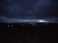
awesome dark sky
bike in the night
dimly lit church
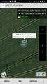
proof


Achievements
Gefrierbrand earned the Land geohash achievement
|
Gefrierbrand earned the Drowned Rat Geohash Honourable Mention
|
Gefrierbrand earned the Bicycle geohash achievement
|