Difference between revisions of "2008-07-09 41 -71"
imported>Ben m (Captioning the pictures.) |
imported>Thomcat (category and map added) |
||
| Line 13: | Line 13: | ||
Image:2008-07-09-41-71-02.jpg|New development follows the old, it seems. None of the houses had been constructed yet... | Image:2008-07-09-41-71-02.jpg|New development follows the old, it seems. None of the houses had been constructed yet... | ||
Image:2008-07-09-41-71-03.jpg|...but they had succeeded in clearing large swaths of forest nonetheless. This bit seems to be designated for drainage. | Image:2008-07-09-41-71-03.jpg|...but they had succeeded in clearing large swaths of forest nonetheless. This bit seems to be designated for drainage. | ||
| + | </gallery> | ||
| + | |||
| + | {{meetup graticule | ||
| + | | map=<map lat="41" lon="-71" date="2008-07-09" /> | ||
| + | | lat=41 | ||
| + | | lon=-71 | ||
| + | | date=2008-07-09 | ||
| + | | graticule_name=Providence | ||
| + | | graticule_link=Providence, Rhode Island | ||
| + | }} | ||
| + | [[Category:Expeditions]] | ||
| + | [[Category:Expeditions with photos]] | ||
Revision as of 18:14, 3 August 2008
The Location
The site is located in Westport, MA, accessible via I-195 exit 11. It is immediately adjacent to White Oak Run Road, at house number ~60.
The Geohash
The hash was only a few meters off of the road, seemingly in the driveway of 60 White Oak Run Road. We decided to settle for the mailbox. The area seems to be a traditional New England phenomenon; a windy road with the occasional older house, and a smattering of new development as well (although where people commute to from Westport I'm not certain).
- Photos for the Day
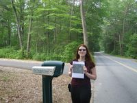
Grace standing at 60 White Oak Run Road (Ben was taking the picture). The hash site was up the driveway a bit.

New development follows the old, it seems. None of the houses had been constructed yet...
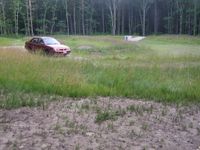
...but they had succeeded in clearing large swaths of forest nonetheless. This bit seems to be designated for drainage.


| Wed 9 Jul 2008 in Providence: 41.5924897, -71.0418876 geohashing.info google osm bing/os kml crox |