Difference between revisions of "2022-04-01 36 -114"
From Geohashing
Felix Dance (talk | contribs) ([retro picture]At the hash) |
Felix Dance (talk | contribs) |
||
| Line 1: | Line 1: | ||
| − | |||
| − | |||
[[Image:{{{image|IMAGE}}}|thumb|left]] | [[Image:{{{image|IMAGE}}}|thumb|left]] | ||
| − | + | {{meetup graticule | |
| − | |||
| − | |||
| − | |||
| − | |||
| lat=36 | | lat=36 | ||
| lon=-114 | | lon=-114 | ||
| Line 14: | Line 8: | ||
__NOTOC__ | __NOTOC__ | ||
== Location == | == Location == | ||
| − | + | In the Nevada desert off the highway to Las Vegas. | |
== Participants == | == Participants == | ||
| − | + | *[[User:Felix Dance|Felix Dance]] | |
| − | + | *Ruth | |
| − | |||
| − | |||
| − | |||
== Expedition == | == Expedition == | ||
| − | + | An excellent, easy geohash. We were driving down the highway towards Las Vegas, saw that it was on the way and that there was a fortuitous service road granting access, and off we went. | |
| + | We parked out little campervan on the dirt road closest to the hash and tromped 150m over the rocky ground to get there. Took a few photos and returned with minimal incidents. | ||
*Geohash reached! -- [[User:Felix Dance|Felix Dance]] ([[User talk:Felix Dance|talk]]) [https://openstreetmap.org/?mlat=36.09949680&mlon=-115.18377920&zoom=16 @36.0995,-115.1838] 16:44, 2 April 2022 (MDT) | *Geohash reached! -- [[User:Felix Dance|Felix Dance]] ([[User talk:Felix Dance|talk]]) [https://openstreetmap.org/?mlat=36.09949680&mlon=-115.18377920&zoom=16 @36.0995,-115.1838] 16:44, 2 April 2022 (MDT) | ||
| Line 57: | Line 49: | ||
<!-- If all those plans are never acted upon, change [[Category:Expedition planning]] to [[Category:Not reached - Did not attempt]]. --> | <!-- If all those plans are never acted upon, change [[Category:Expedition planning]] to [[Category:Not reached - Did not attempt]]. --> | ||
| − | |||
[[Category:Expeditions]] | [[Category:Expeditions]] | ||
| − | + | [[Category:Expeditions with photos]] | |
| − | [[Category:Expeditions with photos]] | ||
| − | |||
| − | |||
| − | |||
| − | |||
| − | |||
[[Category:Coordinates reached]] | [[Category:Coordinates reached]] | ||
| − | |||
| − | |||
| − | |||
| − | |||
| − | |||
| − | |||
| − | |||
| − | |||
| − | |||
| − | |||
| − | |||
| − | |||
| − | |||
| − | |||
| − | |||
| − | |||
| − | |||
| − | |||
Revision as of 22:49, 2 April 2022
| Fri 1 Apr 2022 in 36,-114: 36.7729124, -114.3780281 geohashing.info google osm bing/os kml crox |
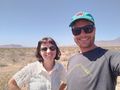
Location
In the Nevada desert off the highway to Las Vegas.
Participants
- Felix Dance
- Ruth
Expedition
An excellent, easy geohash. We were driving down the highway towards Las Vegas, saw that it was on the way and that there was a fortuitous service road granting access, and off we went.
We parked out little campervan on the dirt road closest to the hash and tromped 150m over the rocky ground to get there. Took a few photos and returned with minimal incidents.
- Geohash reached! -- Felix Dance (talk) @36.0995,-115.1838 16:44, 2 April 2022 (MDT)
Tracklog
Photos
At the hash
