Difference between revisions of "2022-04-11 58 5"
From Geohashing
(→Photos) |
(→Photos) |
||
| Line 40: | Line 40: | ||
Image:2022-04-11_58_5_Pica42_1649656921854.jpg|Kyllingstad [https://openstreetmap.org/?mlat=58.74300370&mlon=5.94749180&zoom=16 @58.7430,5.9475] | Image:2022-04-11_58_5_Pica42_1649656921854.jpg|Kyllingstad [https://openstreetmap.org/?mlat=58.74300370&mlon=5.94749180&zoom=16 @58.7430,5.9475] | ||
<gallery> | <gallery> | ||
| − | Image: | + | Image:20220411_02.jpg |
</gallery> | </gallery> | ||
</gallery> | </gallery> | ||
Revision as of 14:33, 11 April 2022
| Mon 11 Apr 2022 in 58,5: 58.7429682, 5.9475058 geohashing.info google osm bing/os kml crox |
Location
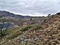
The hash was on a slope in Kyllingstad, Gjesdal, Norway.
Participants
Plans
Expedition
I started the trip early in the morning, at 07:00. It was less than 400 meters in a straight line from where I parked to the hash.
Tracklog

Photos
Kyllingstad @58.7430,5.9475


</gallery>
Achievements