Difference between revisions of "2022-04-12 36 -83"
(Created blank page) |
|||
| Line 1: | Line 1: | ||
| + | <!-- If you did not specify these parameters in the template, please substitute appropriate values for IMAGE, LAT, LON, and DATE (YYYY-MM-DD format) | ||
| + | [[Image:{{{image|IMAGE}}}|thumb|left]] | ||
| + | |||
| + | Remove this section if you don't want an image at the top (left) of your report. You should remove the "Image:" or "File:" | ||
| + | tag from your image file name, and replace the all upper-case word IMAGE in the above line. | ||
| + | |||
| + | And DON'T FORGET to add your expedition and the best photo you took to the gallery on the Main Page! We'd love to read your report, but that means we first have to discover it! :) | ||
| + | -->{{meetup graticule | ||
| + | | lat=34 | ||
| + | | lon=-84 | ||
| + | | date=2022-04-06 | ||
| + | }}<!-- edit as necessary --> | ||
| + | __NOTOC__ | ||
| + | |||
| + | |||
| + | == Location == | ||
| + | <!-- where you've surveyed the hash to be --> | ||
| + | |||
| + | In a field near I-40 in Knoxville, Tennessee. | ||
| + | |||
| + | == Participants == | ||
| + | <!-- who attended: If you link to your wiki user name in this section, your expedition will be picked up by the various statistics generated for geohashing. You may use three tildes ~ as a shortcut to automatically insert the user signature of the account you are editing with. | ||
| + | --> | ||
| + | |||
| + | [[User:Maladroit|Maladroit]] | ||
| + | |||
| + | == Plans == | ||
| + | <!-- what were the original plans --> | ||
| + | |||
| + | Well, here I am all of six days after claiming that my April 6 geohash was my easiest yet, revising that award to refer instead to this even easier one. All told, it was a seven-minute detour from my commute for the day, and one I was probably going to take anyway to stop by a nearby restaurant. | ||
| + | |||
| + | == Expedition == | ||
| + | <!-- how it all turned out. your narrative goes here. --> | ||
| + | |||
| + | The only major inconvenience was that it was raining again. I did plan ahead enough to have an umbrella on hand for this hash, but that makes three out of three hashes which I've gotten at least a bit damp to achieve (twice thanks to rain, once thanks to tramping through a river). On the upside, at least I didn't have to trek through mud to reach the hash—it was just off the road and in an open field, so I just parked by the side of the street and took a short walk over. I managed to protect myself from the rain for the most part...and then ruined it by promptly soaking myself when I tried to stow my umbrella. | ||
| + | |||
| + | == Photos == | ||
| + | <!-- Insert pictures between the gallery tags using the following format: | ||
| + | Image:2022-02-10 ## ## Alpha.jpg | Witty Comment | ||
| + | --> | ||
| + | <gallery perrow="5"> | ||
| + | |||
| + | Image:Maladroit_12-04-21_coordinates.PNG | The coordinates | ||
| + | Image:Maladroit_12-04-21_umbrella.jpg | Just chilling in the rain with an umbrella | ||
| + | Image:Maladroit_12-04-21_friend.jpg | A friend who presumably hitched a ride with me! I set it free when I pulled over a few minutes later. | ||
| + | |||
| + | </gallery> | ||
| + | |||
| + | == Achievements == | ||
| + | {{#vardefine:ribbonwidth|800px}} | ||
| + | <!-- Add any achievement ribbons you earned below, or remove this section --> | ||
| + | |||
| + | {{Drowned rat geohash | ||
| + | |||
| + | | latitude = 36 | ||
| + | | longitude = -84 | ||
| + | | date = 2022-04-12 | ||
| + | | name = Maladroit | ||
| + | | reason = mishandling a sopping umbrella | ||
| + | }} | ||
| + | |||
| + | [[Category:Expeditions]] | ||
| + | [[Category:Expeditions with photos]] | ||
| + | [[Category:Coordinates reached]] | ||
| + | {{location|US|GA|BT}} | ||
Revision as of 02:02, 13 April 2022
| Wed 6 Apr 2022 in 34,-84: 34.3070049, -84.8303935 geohashing.info google osm bing/os kml crox |
Location
In a field near I-40 in Knoxville, Tennessee.
Participants
Plans
Well, here I am all of six days after claiming that my April 6 geohash was my easiest yet, revising that award to refer instead to this even easier one. All told, it was a seven-minute detour from my commute for the day, and one I was probably going to take anyway to stop by a nearby restaurant.
Expedition
The only major inconvenience was that it was raining again. I did plan ahead enough to have an umbrella on hand for this hash, but that makes three out of three hashes which I've gotten at least a bit damp to achieve (twice thanks to rain, once thanks to tramping through a river). On the upside, at least I didn't have to trek through mud to reach the hash—it was just off the road and in an open field, so I just parked by the side of the street and took a short walk over. I managed to protect myself from the rain for the most part...and then ruined it by promptly soaking myself when I tried to stow my umbrella.
Photos
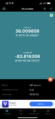
The coordinates

Just chilling in the rain with an umbrella
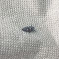
A friend who presumably hitched a ride with me! I set it free when I pulled over a few minutes later.


Achievements
Maladroit earned the Drowned Rat Geohash Achievement
|