Difference between revisions of "2022-04-19 59 17"
Enjoythecode (talk | contribs) ([live picture]I'm here! My first successful expedition, whooo!!! [https://openstreetmap.org/?mlat=59.22289650&mlon=17.93209360&zoom=16 @59.2229,17.9321]) |
Enjoythecode (talk | contribs) (tell about my expedition!) |
||
| Line 14: | Line 14: | ||
__NOTOC__ | __NOTOC__ | ||
== Location == | == Location == | ||
| − | + | In the parking lot of a Hospital in Flemingsberg, Sweden. | |
== Participants == | == Participants == | ||
| − | + | [[User:Enjoythecode|enjoythecode]] ([[User talk:Enjoythecode|talk]]) | |
| − | |||
== Plans == | == Plans == | ||
| − | + | Go there using public transport (green line, then bus to within 5 minutes walking distance), and then head back to my room using a different set of public transport (commuter rail, then orange tram). | |
== Expedition == | == Expedition == | ||
| − | + | Getting there was smooth sailing, thanks to Sweden's wonderfully walkable design and the well-oiled public transit system. | |
| − | + | Flemingsberg seems to have a majority-immigrant population. Notably, I've noticed multiple (5+) Turkish conversations happening around me, as well as a restaurant with a Turkish name, suggesting that a migrant community from Turkey has formed around this area. The fact that central Stockholm is much more mono-ethnically Swedish white and that immigrants and refugees are "outsourced" to peripheral cities is hard to miss; even more so since I am taking a class on Swedish and U.S. Migration Policy during my semester here in Sweden. | |
| − | |||
== Photos == | == Photos == | ||
| Line 40: | Line 38: | ||
== Achievements == | == Achievements == | ||
{{#vardefine:ribbonwidth|800px}} | {{#vardefine:ribbonwidth|800px}} | ||
| − | + | {{land geohash | latitude = 59 | longitude = 17 | date = 2022-04-19 | name = enjoythecode | image = 2022-04-19_59_17_enjoythecode_1650372544283.jpg }} | |
| − | + | {{Public transport geohash | latitude = 59 | longitude = 17 | date = 2022-04-19 | busline = Green Line (19) + Bus 172 | name = enjoythecode }} | |
| − | |||
| − | |||
| − | |||
| − | |||
| − | |||
| − | |||
| − | |||
| − | |||
| − | |||
| − | |||
| − | <!-- | + | <!-- == Categories == --> |
| − | |||
[[Category:Expeditions]] | [[Category:Expeditions]] | ||
| − | |||
[[Category:Expeditions with photos]] | [[Category:Expeditions with photos]] | ||
| − | |||
| − | |||
| − | |||
| − | |||
| − | |||
[[Category:Coordinates reached]] | [[Category:Coordinates reached]] | ||
| − | |||
| − | |||
| − | |||
| − | |||
| − | |||
| − | |||
| − | |||
| − | |||
| − | |||
| − | |||
| − | |||
| − | |||
| − | |||
| − | |||
| − | |||
| − | |||
| − | |||
| − | |||
Revision as of 12:46, 20 April 2022
| Tue 19 Apr 2022 in 59,17: 59.2228856, 17.9320872 geohashing.info google osm bing/os kml crox |
Location
In the parking lot of a Hospital in Flemingsberg, Sweden.
Participants
Plans
Go there using public transport (green line, then bus to within 5 minutes walking distance), and then head back to my room using a different set of public transport (commuter rail, then orange tram).
Expedition
Getting there was smooth sailing, thanks to Sweden's wonderfully walkable design and the well-oiled public transit system.
Flemingsberg seems to have a majority-immigrant population. Notably, I've noticed multiple (5+) Turkish conversations happening around me, as well as a restaurant with a Turkish name, suggesting that a migrant community from Turkey has formed around this area. The fact that central Stockholm is much more mono-ethnically Swedish white and that immigrants and refugees are "outsourced" to peripheral cities is hard to miss; even more so since I am taking a class on Swedish and U.S. Migration Policy during my semester here in Sweden.
Photos
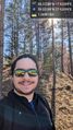
I'm here! My first successful expedition, whooo!!! @59.2229,17.9321

Achievements
enjoythecode earned the Land geohash achievement
|
enjoythecode earned the Public transport geohash achievement
|