Difference between revisions of "2010-10-21 48 11"
imported>FippeBot m (Location) |
m |
||
| Line 57: | Line 57: | ||
[[Category:Expeditions with photos]] | [[Category:Expeditions with photos]] | ||
[[Category:Expedition without GPS]] | [[Category:Expedition without GPS]] | ||
| + | [[Category:Not reached - Technology]] | ||
[[Category:Coordinates not reached]] | [[Category:Coordinates not reached]] | ||
{{location|DE|BY|EBE}} | {{location|DE|BY|EBE}} | ||
Latest revision as of 09:08, 24 April 2022
| Thu 21 Oct 2010 in 48,11: 48.1469881, 11.9205254 geohashing.info google osm bing/os kml crox |
Location
The geohash was in Ebersberger Forst, close to St2080, near Schwaberwegen.
Participants
Plans
The plan was exactly how it turned out (see below), except that I did have a small hope I would be able to find the coords without a GPS.
Expedition
I failed because the spot was somewhat close to the road, somewhat close to an intersection with a dirt road that I used as an landmark, but all in all, I could only be sure to be within a range < 250 m to the coords -- too inaccurate for calling it a success. Time to finally get a GPS receiver.
The entire day, however, was very cool: It started out with a tour of a semiconductor fab, included a nice bus ride around München's airport and through the Finsing bog, featured fall colors and an almost full moon, and ended with a nice folk/punk show.
Photos
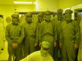
Another adventure prior to exploring the geohash. The green creatures with blurred eyes are 1 boss and 4 coworkers, the white creature with blurred eyes is the engineer who acted as our tour guide.
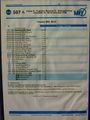
The best (and acutually quickest) route for circling from München's N to München's East at this time of the afternoon involved a bus that runs only once a day.


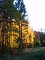
The beauty of fall colors...
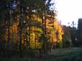
... is maybe the most important reason...
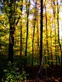
... to geohash at this time of the year.


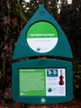
Waldvergnougat! Let the fun of finding the coords begin.
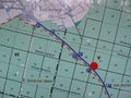
A map! A map! The coords must be in section 26, just S of the red dot that tells me that I am where it is. U bevindt zich hier, as the Dutch say.
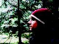
Playing with GIMP's filters to make this picture look somewhat like an adventure game on a 8086 with a CGA graphics card.
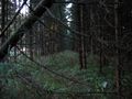
This must be within close range to the actual coords. No really good landmarks are available, however, to match my brought-along satellite printouts with my actual position.


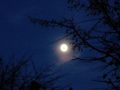
After walking back NW to Schwaberwegen, the moon looks nice while I wait for the bus to Ebersberg.
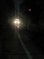
Ebersberg. The Filzenexpress is coming in from Wasserburg Bf to take me to Grafing Bf, where I will connect to München Ost. This was the first night with sub-zero temperatures. At home, we harvested the last zucchini of the year before they would freeze and rot.


Another adventure after exploring the geohash. I was early; later, there were way more than five paying guests.
