Difference between revisions of "2022-05-15 51 9"
(Created page with "{{meetup graticule | lat=51 | lon=9 | date=2022-05-15 }} <!-- edit as necessary --> __NOTOC__ == Location == In a forest north of Hedemünden == Participants == User:Dig...") |
|||
| Line 20: | Line 20: | ||
== Expedition == | == Expedition == | ||
<!-- how it all turned out. your narrative goes here --> | <!-- how it all turned out. your narrative goes here --> | ||
| − | + | As planned, I did a nice walk to the geohash, which was very easy to access, since there was a nice path leading straight to the hash, so I didn't have to crawl through bushes or thorny stuff... Simply walked to the hash, got under 1 meter accuracy within less than one minute, took proof and continued my walk through this wood, where I had never been before. So, I made a 8 km hike and got back to my car 1 pm and drove home... Nothing really exciting actually... | |
== Photos == | == Photos == | ||
<gallery> | <gallery> | ||
Image:2022-05-15_51_9_001.jpg|On my way to the hash | Image:2022-05-15_51_9_001.jpg|On my way to the hash | ||
| − | Image:2022-05-15_51_9_002.jpg| | + | Image:2022-05-15_51_9_002.jpg|Path to the hash |
| − | Image:2022-05-15_51_9_003.jpg| | + | Image:2022-05-15_51_9_003.jpg|The hash |
| − | Image:2022-05-15_51_9_004.jpg|The hasher at the | + | Image:2022-05-15_51_9_004.jpg|The hasher at the hash location |
| − | Image:2022-05-15_51_9_005.jpg| | + | Image:2022-05-15_51_9_005.jpg|The hash was this tree |
| − | Image:2022-05-15_51_9_006.jpg| | + | Image:2022-05-15_51_9_006.jpg|On my way back |
| − | Image:2022-05-15_51_9_007.jpg| | + | Image:2022-05-15_51_9_007.jpg|Parking lot |
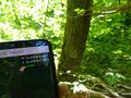
Image:2022-05-15_51_9_008.jpg|Proof | Image:2022-05-15_51_9_008.jpg|Proof | ||
</gallery> | </gallery> | ||
| Line 37: | Line 37: | ||
[[Category:Expeditions with photos]] | [[Category:Expeditions with photos]] | ||
[[Category:Coordinates reached]] | [[Category:Coordinates reached]] | ||
| − | |||
| − | |||
{{location|DE|NI|GÖ}} | {{location|DE|NI|GÖ}} | ||
Latest revision as of 16:01, 15 May 2022
| Sun 15 May 2022 in 51,9: 51.4132375, 9.7852040 geohashing.info google osm bing/os kml crox |
Location
In a forest north of Hedemünden
Participants
Plans
I will go for a nice walk through the woods - the hash seems to lay only some 25 meters off the main path, so it should be an easy one... After the geohash, I will do another walk with some geocaches near Lippoldshausen...
Expedition
As planned, I did a nice walk to the geohash, which was very easy to access, since there was a nice path leading straight to the hash, so I didn't have to crawl through bushes or thorny stuff... Simply walked to the hash, got under 1 meter accuracy within less than one minute, took proof and continued my walk through this wood, where I had never been before. So, I made a 8 km hike and got back to my car 1 pm and drove home... Nothing really exciting actually...
Photos
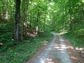
On my way to the hash
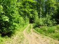
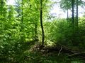
Path to the hash
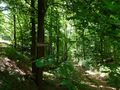
The hash
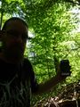
The hasher at the hash location
The hash was this tree
On my way back
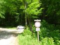
Parking lot
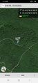
Proof


