Difference between revisions of "2022-06-03 48 7"
From Geohashing
m (Location) |
(→Photos: Add photos) |
||
| Line 14: | Line 14: | ||
== Photos == | == Photos == | ||
<gallery> | <gallery> | ||
| + | Image:2022-06-03 48 7 01.jpg | My bicycle near the geohash | ||
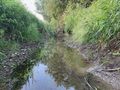
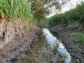
| + | Image:2022-06-03 48 7 02.jpg | The geohash | ||
| + | Image:2022-06-03 48 7 03.png | Coordinates reached | ||
| + | Image:2022-06-03 48 7 04.jpg | Surroundings (North-East) | ||
| + | Image:2022-06-03 48 7 05.jpg | Surroundings (South-West) | ||
| + | Image:2022-06-03 48 7 06.jpg | Stupid grin | ||
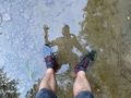
| + | Image:2022-06-03 48 7 07.jpg | Standing on the coordinates | ||
</gallery> | </gallery> | ||
| Line 35: | Line 42: | ||
__NOTOC__ | __NOTOC__ | ||
[[Category:Expeditions]] | [[Category:Expeditions]] | ||
| + | [[Category:Expeditions with photos]] | ||
{{location|FR|67}} | {{location|FR|67}} | ||
Revision as of 11:50, 4 June 2022
| Fri 3 Jun 2022 in 48,7: 48.2445038, 7.4544887 geohashing.info google osm bing/os kml crox |
Location
In a streamlet near Sélestat.
Participants
Expedition
Photos
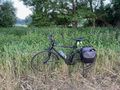
My bicycle near the geohash
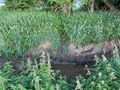
The geohash
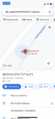
Coordinates reached
Surroundings (North-East)
Surroundings (South-West)

Stupid grin
Standing on the coordinates


Achievements
Baarde earned the Land geohash achievement
|
Baarde earned the Bicycle geohash achievement
|