Difference between revisions of "2022-06-13 62 29"
(Created page with "{{Subst:Expedition}}") |
|||
| Line 1: | Line 1: | ||
| − | + | {{meetup graticule | |
| − | |||
| − | |||
| − | |||
| − | |||
| − | |||
| − | |||
| − | |||
| − | |||
| lat={{#explode:{{SUBPAGENAME}}| |1}} | | lat={{#explode:{{SUBPAGENAME}}| |1}} | ||
| lon={{#explode:{{SUBPAGENAME}}| |2}} | | lon={{#explode:{{SUBPAGENAME}}| |2}} | ||
| date={{#explode:{{SUBPAGENAME}}| |0}} | | date={{#explode:{{SUBPAGENAME}}| |0}} | ||
| − | }} | + | }} |
__NOTOC__ | __NOTOC__ | ||
== Location == | == Location == | ||
| − | + | In a forest in western Jaamankangas, on the slope of a small hill. | |
| + | |||
| + | The point on a topographic map: {{MapSiteLink | lat = 62.6827806 | lon = 29.6898753 | title = Geohash+2022-06-13+62+29}} | ||
== Participants == | == Participants == | ||
| − | + | * [[User:Kripakko|Kripakko]] | |
| − | + | * A million mosquitoes | |
| − | == | + | == Expedition == |
| − | + | This hashpoint ended up in a location that was easily accessible by bicycle. I have been thinking of doing a [[Camping geohash achievement|Camping Geohash]] for a long time, but no good chances have yet come up. This one would be nearly perfect: it was within a relatively short distance, in a place where I can place a tent and sleep in it (many types of terrain are unsuitable for various reasons), and the weather would be nice (temperature 15–20 °C with possible showers in the night). I could carry my small tent and a sleeping bag on the rear rack and other equipment in a backpack. The sun would set at 23:00 and rise at 3:02 (source: [https://www.timeanddate.com/sun/@62.68278,29.68988?month=6&year=2022]), and there would only be civil twilight even at solar midnight, so I would not need an artificial light source. | |
| − | + | I set off at about 22:50 on Sunday 2022-06-12. I thought that I would have way more than enough time to get there and set up a camp before midnight, and I did, but I was slowed down more than I would have liked by road conditions. Marjosärkäntie and Kyyrönsuontie roads were so bumpy in places that I had to ride slowly to prevent my load from falling off the rack. The forest road from Jaamankankaantie road to the geohash was covered with substantial rocks and roots and in some places soft sand, so I had to go slowly again. I kept wondering how many spokes would break during the rough trip, but thankfully none did. I eventually reached the loop at the end of the forest road at 23:40 and walked the last sixty metres with all the equipment. A swarm of mosquitoes immediately started to follow me and attacked me once I stopped at the hashpoint. The terrain had quite a slope, and there were lots of tree stumps and fallen branches on the ground, so I had to pick a place for the tent a few metres away from the hashpoint. I pitched the tent as quickly as I could, took a few quick photos and ran inside leaving all mosquitoes outside. | |
| − | + | ||
| + | Midnight came and went, and I fell asleep at some point between half twelve and one. I woke up a few times to reposition myself or to listen to mosquitoes or an occasional shower. The tent is water-resistant, so everything inside stayed dry, and the rain was mild enough that the plants and the ground absorbed it all, so when I woke up at eight, everything except the outer layer of the tent was dry. I took my time to get up and ate a light breakfast consisting of two carrots, two satsumas, a protein drink and water. I thought I could claim a [[Picnic achievement]], but I did not remember that I needed to bring specific picnic accessories with me. I only realised this when I was back at home. Damn! Oh well, I can try this again later. | ||
| + | |||
| + | ''To be continued...'' | ||
| + | |||
| + | According to my GPS receiver, the length of the trip was 33.7 km, of which I cycled 33.5 km. | ||
== Tracklog == | == Tracklog == | ||
| − | + | {{tracklog|2022-06-13_62_29_tracklog.gpx}} | |
== Photos == | == Photos == | ||
| − | < | + | <gallery perrow="6"> |
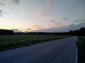
| − | Image: | + | Image:2022-06-13_62_29_01-sunset.jpg | Riding into the sunset. The sun had actually set nine minutes before. |
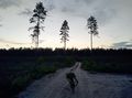
| − | -- | + | Image:2022-06-13_62_29_02-dirtroad.jpg | The dirt road that I rode through Jaaman­kangas. |
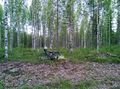
| − | + | Image:2022-06-13_62_29_03-bicycle.jpg | The bicycle parked to the roadside. Sixty metres to go. | |
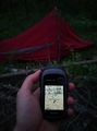
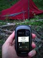
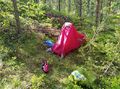
| + | Image:2022-06-13_62_29_04-gpsr1.jpg | The tent has been pitched. Proof of location. | ||
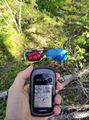
| + | Image:2022-06-13_62_29_05-gpsr2.jpg | Proof of date and time. It is still a few minutes to midnight. | ||
| + | Image:2022-06-13_62_29_06-midnight-screenshot.png | I was unable to photo­graph the GPS receiver screen in the dark tent, so have this pair of screen­shots as proof of Midnight Geohash. | ||
| + | Image:2022-06-13_62_29_07-selfie.jpg | Selfie in the tent in the morning. | ||
| + | Image:2022-06-13_62_29_08-breakfast.jpg | The light breakfast. | ||
| + | Image:2022-06-13_62_29_09-tent.jpg | The tent in the morning before packing it up. | ||
| + | Image:2022-06-13_62_29_10-gpsr3.jpg | The tent has been packed up, another proof of location. | ||
| + | Image:2022-06-13_62_29_11-road1.jpg | Puntari­kosken­tie road. | ||
| + | Image:2022-06-13_62_29_12-road2.jpg | Linjatie road. | ||
</gallery> | </gallery> | ||
== Achievements == | == Achievements == | ||
{{#vardefine:ribbonwidth|800px}} | {{#vardefine:ribbonwidth|800px}} | ||
| − | + | {{land geohash | latitude = 62 | longitude = 29 | date = 2022-06-13 | name = Kripakko}} | |
| + | {{bicycle geohash | latitude = 62 | longitude = 29 | date = 2022-06-13 | name = Kripakko | distance = 33.5 km | bothways = true}} | ||
| + | {{midnight geohash | latitude = 62 | longitude = 29 | date = 2022-06-13 | name = Kripakko}} | ||
| + | {{sunrise geohash | latitude = 62 | longitude = 29 | date = 2022-06-13 | name = Kripakko}} | ||
| + | {{camping geohash | latitude = 62 | longitude = 29 | date = 2022-06-13 | name = Kripakko | arrival = 23:43 | departure = 8:55 | residence = a tent }} | ||
| + | {{Radio Yerevan | achievement = Picnic achievement | detail = he did not bring any picnic accessories with him, and while he had tissue paper that did serve as napkins, he failed to photograph them and himself in action | latitude = 62 | longitude = 29 | date = 2022-06-13 | user = Kripakko}} | ||
<!-- =============== USEFUL CATEGORIES FOLLOW ================ | <!-- =============== USEFUL CATEGORIES FOLLOW ================ | ||
Revision as of 21:34, 13 June 2022
| Mon 13 Jun 2022 in 62,29: 62.6827806, 29.6898753 geohashing.info google osm bing/os kml crox |
Location
In a forest in western Jaamankangas, on the slope of a small hill.
The point on a topographic map: [1]
Participants
- Kripakko
- A million mosquitoes
Expedition
This hashpoint ended up in a location that was easily accessible by bicycle. I have been thinking of doing a Camping Geohash for a long time, but no good chances have yet come up. This one would be nearly perfect: it was within a relatively short distance, in a place where I can place a tent and sleep in it (many types of terrain are unsuitable for various reasons), and the weather would be nice (temperature 15–20 °C with possible showers in the night). I could carry my small tent and a sleeping bag on the rear rack and other equipment in a backpack. The sun would set at 23:00 and rise at 3:02 (source: [2]), and there would only be civil twilight even at solar midnight, so I would not need an artificial light source.
I set off at about 22:50 on Sunday 2022-06-12. I thought that I would have way more than enough time to get there and set up a camp before midnight, and I did, but I was slowed down more than I would have liked by road conditions. Marjosärkäntie and Kyyrönsuontie roads were so bumpy in places that I had to ride slowly to prevent my load from falling off the rack. The forest road from Jaamankankaantie road to the geohash was covered with substantial rocks and roots and in some places soft sand, so I had to go slowly again. I kept wondering how many spokes would break during the rough trip, but thankfully none did. I eventually reached the loop at the end of the forest road at 23:40 and walked the last sixty metres with all the equipment. A swarm of mosquitoes immediately started to follow me and attacked me once I stopped at the hashpoint. The terrain had quite a slope, and there were lots of tree stumps and fallen branches on the ground, so I had to pick a place for the tent a few metres away from the hashpoint. I pitched the tent as quickly as I could, took a few quick photos and ran inside leaving all mosquitoes outside.
Midnight came and went, and I fell asleep at some point between half twelve and one. I woke up a few times to reposition myself or to listen to mosquitoes or an occasional shower. The tent is water-resistant, so everything inside stayed dry, and the rain was mild enough that the plants and the ground absorbed it all, so when I woke up at eight, everything except the outer layer of the tent was dry. I took my time to get up and ate a light breakfast consisting of two carrots, two satsumas, a protein drink and water. I thought I could claim a Picnic achievement, but I did not remember that I needed to bring specific picnic accessories with me. I only realised this when I was back at home. Damn! Oh well, I can try this again later.
To be continued...
According to my GPS receiver, the length of the trip was 33.7 km, of which I cycled 33.5 km.
Tracklog
Photos
Riding into the sunset. The sun had actually set nine minutes before.
The dirt road that I rode through Jaamankangas.
The bicycle parked to the roadside. Sixty metres to go.
The tent has been pitched. Proof of location.
Proof of date and time. It is still a few minutes to midnight.
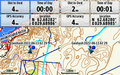
I was unable to photograph the GPS receiver screen in the dark tent, so have this pair of screenshots as proof of Midnight Geohash.
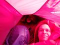
Selfie in the tent in the morning.
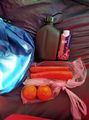
The light breakfast.
The tent in the morning before packing it up.
The tent has been packed up, another proof of location.
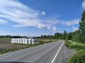
Puntarikoskentie road.
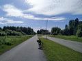
Linjatie road.


Achievements
Kripakko earned the Land geohash achievement
|
Kripakko earned the Bicycle geohash achievement
|
Kripakko earned the Midnight Geohash achievement
|
Kripakko earned the Sunrise Geohash Achievement
|
Kripakko earned the Camping geohash achievement
|
Is it true that Kripakko earned the Picnic achievement?
|