Difference between revisions of "2023-03-23 33 35"
Yerushalmi (talk | contribs) (→Plans) |
Yerushalmi (talk | contribs) |
||
| Line 22: | Line 22: | ||
== Expedition == | == Expedition == | ||
| − | + | Expedition went almost without a hitch. There was unfortunately a half-hour wait between my arrival in Nahariya and the first bus to Betzet, so I sat at the bus stop and worked a little. Took the twenty-something bus to the town of Betzet. The bus driver somehow didn't notice that I pressed the Stop button, but when I saw he wasn't slowing down I called out to him and he belatedly realized, stopping about 200 meters past the bus stop. I walked along the highway back to the entrance to Betzet. | |
| − | + | Inside Betzet, I took the first right from the main road onto a dirt path leading to a field. After a few steps I had second thoughts - I saw the dirt path was merging with another one a little bit further down the road, and that entrance had a gate. So I turned around, left the field, and headed down to the gate. Yup: Private Property. | |
| − | + | ||
| + | Well, the point was further to the south than both the first and second entrances, so maybe that bit of it wasn't private property? I headed down to the *third* entrance, which was a paved road that led first to a small home decoration shop and then through an opening in a corrugated metal wall. No private property signs, so I walked through it, but deliberately slowly, hoping someone in the shop would happen to be not serving customers at that moment and I could ask them. No such luck. | ||
| + | |||
| + | Oh well. Kept walking and reached the south side of three large warehouses; according to the map, the point was on the north side. The path between the second and third warehouses was open so I walked north, turned right, and reached the hashpoint with ease. | ||
| + | |||
| + | There was a small mud puddle exactly on the point, so I drew XKCD in it with the tip of my boot. | ||
| + | |||
| + | I had to again wait half an hour for the bus on the way back, so I worked from the bus stop again. Had a gluten-free pita falafel at Falafel Tinami when I got back to Nahariya. Most gluten-free pitas are terrible. This one was excellent. | ||
== Photos == | == Photos == | ||
| Line 32: | Line 39: | ||
--> | --> | ||
<gallery perrow="5"> | <gallery perrow="5"> | ||
| + | Image:20230323_113525.jpg | Panorama at the point | ||
| + | Image:20230323_113517.jpg | XKCD in a mud puddle | ||
| + | Image:Screenshot_20230323_113511_Geohash Droid.jpg | Witty Comment | ||
</gallery> | </gallery> | ||
| Line 37: | Line 47: | ||
{{#vardefine:ribbonwidth|100%}} | {{#vardefine:ribbonwidth|100%}} | ||
<!-- Add any achievement ribbons you earned below, or remove this section --> | <!-- Add any achievement ribbons you earned below, or remove this section --> | ||
| + | {{Virgin graticule | ||
| − | + | | latitude = 33 | |
| − | + | | longitude = 35 | |
| − | + | | date = 2023-03-23 | |
| − | + | | name = Yerushalmi | |
| + | | image = Screenshot_20230323_113511_Geohash Droid.jpg | ||
| − | + | }} | |
| − | + | __NOTOC__ | |
| − | |||
| − | |||
| − | |||
| − | |||
| − | |||
| − | |||
[[Category:Expeditions]] | [[Category:Expeditions]] | ||
| − | |||
[[Category:Expeditions with photos]] | [[Category:Expeditions with photos]] | ||
| − | |||
| − | |||
| − | |||
| − | |||
| − | |||
[[Category:Coordinates reached]] | [[Category:Coordinates reached]] | ||
| − | |||
| − | |||
| − | |||
| − | |||
| − | |||
| − | |||
| − | |||
| − | |||
| − | |||
| − | |||
| − | |||
| − | |||
| − | |||
| − | |||
| − | |||
| − | |||
| − | |||
| − | |||
Revision as of 11:21, 23 March 2023
| Thu 23 Mar 2023 in 33,35: 33.0748450, 35.1294254 geohashing.info google osm bing/os kml crox |
Location
Just outside some kind of agricultural building (barn? warehouse?) in the far north of Israel, a town called Betzet.
Participants
Yerushalmi (talk) is interested in taking a train day.
Plans
Yerushalmi (talk): Train day! Get on the Jerusalem-Modi'in train, then switch to the Modi'in-Nahariya train, then take the bus to Betzet (15 minutes).
Expedition
Expedition went almost without a hitch. There was unfortunately a half-hour wait between my arrival in Nahariya and the first bus to Betzet, so I sat at the bus stop and worked a little. Took the twenty-something bus to the town of Betzet. The bus driver somehow didn't notice that I pressed the Stop button, but when I saw he wasn't slowing down I called out to him and he belatedly realized, stopping about 200 meters past the bus stop. I walked along the highway back to the entrance to Betzet.
Inside Betzet, I took the first right from the main road onto a dirt path leading to a field. After a few steps I had second thoughts - I saw the dirt path was merging with another one a little bit further down the road, and that entrance had a gate. So I turned around, left the field, and headed down to the gate. Yup: Private Property.
Well, the point was further to the south than both the first and second entrances, so maybe that bit of it wasn't private property? I headed down to the *third* entrance, which was a paved road that led first to a small home decoration shop and then through an opening in a corrugated metal wall. No private property signs, so I walked through it, but deliberately slowly, hoping someone in the shop would happen to be not serving customers at that moment and I could ask them. No such luck.
Oh well. Kept walking and reached the south side of three large warehouses; according to the map, the point was on the north side. The path between the second and third warehouses was open so I walked north, turned right, and reached the hashpoint with ease.
There was a small mud puddle exactly on the point, so I drew XKCD in it with the tip of my boot.
I had to again wait half an hour for the bus on the way back, so I worked from the bus stop again. Had a gluten-free pita falafel at Falafel Tinami when I got back to Nahariya. Most gluten-free pitas are terrible. This one was excellent.
Photos
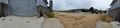
Panorama at the point
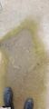
XKCD in a mud puddle
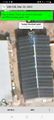
Witty Comment

