Difference between revisions of "2023-06-12 31 34"
Yerushalmi (talk | contribs) (Created page with "{{subst:Expedition |lat = 31 |lon = 34 |date = 2023-06-12 }}") |
Yerushalmi (talk | contribs) |
||
| Line 13: | Line 13: | ||
}}<!-- edit as necessary --> | }}<!-- edit as necessary --> | ||
== Location == | == Location == | ||
| − | + | In untended wilderness area outside of the town of Shekef. | |
== Participants == | == Participants == | ||
| − | + | [[User:Yerushalmi|Yerushalmi]] ([[User talk:Yerushalmi|talk]]) | |
| − | |||
== Plans == | == Plans == | ||
| − | + | Shekef is served by maybe one bus every three hours. Unless I want to leave at an ungodly hour in the morning, I'll have to take a massively roundabout train route through Tel Aviv, then a bus. I had to choose between this and 32 34 on the same day, but 32 34 looks to be a plowed field and therefore less likely to be a success. | |
== Expedition == | == Expedition == | ||
| − | + | I got off the bus in Shekef at midday and walked through the moshav towards the hashpoint. On the road to the point there were greenhouses on the right and a goat farm to the left. The point is on the left, somewhere after the goat farm. Guard dogs barked and somebody in the goat farm looked at me curiously as I walked past. | |
| − | + | The goat farm ended - but, worryingly, the fencing along the side of the road did not. It was basically a rocky promontory, completely untended by human hand, with the familiar desert burrs that grow everywhere in this country. But it was fenced off. I hoped and prayed the fence would end before the point. It didn't. | |
| − | + | ||
| + | Ah, but the fence ends 30 meters after the point, and hooks backwards diagonally up the hill, like this: | ||
| + | \ | ||
| + | \ | ||
| + | fence \ | ||
| + | _-_-_-_-_- | ||
| + | road | ||
| + | _________ | ||
| + | |||
| + | So maybe I'll get lucky and the point will be beyond the second fence and accessible? I turned off the road and climbed up the hill along the fence - but no, GPS puts the point squarely inside the fence triangle. | ||
| + | |||
| + | Hang on, wasn't there someone in the goat farm? Let's go ask them who this belongs to. I climbed back down the hill and back up the road. | ||
| + | |||
| + | The conversation went pretty standard for my geohashing encounters with the public: "Can I go in there?" "Where are you from?" "Jerusalem." "Why do you want to go there?" "Well, I've got this app..." | ||
| + | |||
| + | I've found that since Pokemon Go was invented it's very easy to explain anything weird you're doing by saying it's for an app. | ||
| + | |||
| + | "So what happens when you get there?" "The app turns green and says I made it there." "Uh-huh." | ||
| + | |||
| + | Well, it turns out the guy in the goat farm *also* owned the fenced-off part of the promontory. He didn't explain, but I assume he uses it to let his goats out and do some grazing on their natural hilly terrain. And he gave me permission to go to the point, for my second-ever Ambassador achievement! | ||
| + | |||
| + | "Wow, thanks! How do I get in?" "Just climb over the fence." | ||
| + | |||
| + | So I went back to the pointy end of the triangle and found a good part of the fence to climb over, climbed up the hill, and took the usual screenshot and panorama photo. Then I found a more stable part of the fence to climb over on the way back out. | ||
| + | |||
| + | The rocky parts of the hill didn't look entirely natural - they had that terraced look that are typical of abandoned Bronze/Iron age settlements all over the country. I'm by no means an expert, though. Still, mission success, and I took an equally roundabout bus route back to Jerusalem. | ||
== Photos == | == Photos == | ||
| − | |||
| − | |||
| − | |||
<gallery perrow="5"> | <gallery perrow="5"> | ||
| + | Image:Screenshot_20230612_132036_Geohash Droid.jpg | Proof of success | ||
| + | Image:20230612_131650.jpg | Uh-oh, the wilderness is fenced off. But maybe it's still accessible, past the other fence? | ||
| + | Image:20230612_131713.jpg | Useful bit of fence to climb over | ||
| + | Image:20230612_132046.jpg | Panorama from the hashpoint | ||
| + | Image:20230612_132255.jpg | There were probably houses here 3000 years ago | ||
</gallery> | </gallery> | ||
| Line 38: | Line 64: | ||
{{#vardefine:ribbonwidth|100%}} | {{#vardefine:ribbonwidth|100%}} | ||
<!-- Add any achievement ribbons you earned below, or remove this section --> | <!-- Add any achievement ribbons you earned below, or remove this section --> | ||
| + | {{Ambassador geohash | ||
| + | |||
| + | | latitude = 31 | ||
| + | | longitude = 34 | ||
| + | | date = 2023-06-12 | ||
| + | | granter = some guy in a goat farm | ||
| + | | name = Yerushalmi | ||
| − | + | }} | |
| − | |||
| − | |||
| − | |||
<!-- ==REQUEST FOR TWITTER BOT== Please leave either the New report or the Expedition planning category in as long as you work on it. This helps the twitter bot a lot with announcing the right outcome at the right moment. --> | <!-- ==REQUEST FOR TWITTER BOT== Please leave either the New report or the Expedition planning category in as long as you work on it. This helps the twitter bot a lot with announcing the right outcome at the right moment. --> | ||
| − | |||
| − | |||
| − | |||
| − | |||
| − | |||
| − | |||
| − | |||
| − | |||
[[Category:Expeditions]] | [[Category:Expeditions]] | ||
| − | |||
| − | |||
| − | |||
| − | |||
| − | |||
| − | |||
[[Category:Coordinates reached]] | [[Category:Coordinates reached]] | ||
| − | |||
| − | |||
| − | |||
| − | |||
| − | |||
| − | |||
| − | |||
| − | |||
| − | |||
| − | |||
| − | |||
| − | |||
| − | |||
| − | |||
| − | |||
| − | |||
| − | |||
| − | |||
Revision as of 13:26, 13 June 2023
| Mon 12 Jun 2023 in 31,34: 31.5068878, 34.9359165 geohashing.info google osm bing/os kml crox |
Location
In untended wilderness area outside of the town of Shekef.
Participants
Plans
Shekef is served by maybe one bus every three hours. Unless I want to leave at an ungodly hour in the morning, I'll have to take a massively roundabout train route through Tel Aviv, then a bus. I had to choose between this and 32 34 on the same day, but 32 34 looks to be a plowed field and therefore less likely to be a success.
Expedition
I got off the bus in Shekef at midday and walked through the moshav towards the hashpoint. On the road to the point there were greenhouses on the right and a goat farm to the left. The point is on the left, somewhere after the goat farm. Guard dogs barked and somebody in the goat farm looked at me curiously as I walked past.
The goat farm ended - but, worryingly, the fencing along the side of the road did not. It was basically a rocky promontory, completely untended by human hand, with the familiar desert burrs that grow everywhere in this country. But it was fenced off. I hoped and prayed the fence would end before the point. It didn't.
Ah, but the fence ends 30 meters after the point, and hooks backwards diagonally up the hill, like this:
         \
          \
   fence   \
   _-_-_-_-_-
   road
   _________
So maybe I'll get lucky and the point will be beyond the second fence and accessible? I turned off the road and climbed up the hill along the fence - but no, GPS puts the point squarely inside the fence triangle.
Hang on, wasn't there someone in the goat farm? Let's go ask them who this belongs to. I climbed back down the hill and back up the road.
The conversation went pretty standard for my geohashing encounters with the public: "Can I go in there?" "Where are you from?" "Jerusalem." "Why do you want to go there?" "Well, I've got this app..."
I've found that since Pokemon Go was invented it's very easy to explain anything weird you're doing by saying it's for an app.
"So what happens when you get there?" "The app turns green and says I made it there." "Uh-huh."
Well, it turns out the guy in the goat farm *also* owned the fenced-off part of the promontory. He didn't explain, but I assume he uses it to let his goats out and do some grazing on their natural hilly terrain. And he gave me permission to go to the point, for my second-ever Ambassador achievement!
"Wow, thanks! How do I get in?" "Just climb over the fence."
So I went back to the pointy end of the triangle and found a good part of the fence to climb over, climbed up the hill, and took the usual screenshot and panorama photo. Then I found a more stable part of the fence to climb over on the way back out.
The rocky parts of the hill didn't look entirely natural - they had that terraced look that are typical of abandoned Bronze/Iron age settlements all over the country. I'm by no means an expert, though. Still, mission success, and I took an equally roundabout bus route back to Jerusalem.
Photos

Proof of success
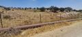
Uh-oh, the wilderness is fenced off. But maybe it's still accessible, past the other fence?
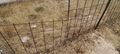
Useful bit of fence to climb over
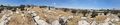
Panorama from the hashpoint
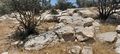
There were probably houses here 3000 years ago


Achievements
Yerushalmi earned the Ambassador achievement
|