Difference between revisions of "2023-08-20 31 34"
Yerushalmi (talk | contribs) |
Yerushalmi (talk | contribs) |
||
| Line 22: | Line 22: | ||
== Expedition == | == Expedition == | ||
| − | |||
| − | + | We drove to the parking lot at the north edge of the forest, on Route 443, and got out. Each of us took 3.5 liters of water, sandwiches and snacks. | |
| − | < | + | |
| + | '''<big>Pro tip:</big>''' I left a printed-out map of the forest, with the geohash point marked on it, in the windshield of our car. In case we got lost, park rangers closing up the forest at nightfall could use it to find us. I do this with every off-road geohash I take with the kids. | ||
| + | |||
| + | It was going to be barely a kilometer in each direction, but still - particularly with the massive heat wave we've had lately, safety is important. And we didn't know in advance if we'd have cell reception (we did, but it was spotty). | ||
| + | |||
| + | With the kids on summer vacation, and me temporarily unemployed, we could take as much time as we wanted. So I did something that I've wanted to do for a long time: I printed out a dozen different maps of the area, handed two to each child, and told them to navigate us to the point without my assistance. | ||
| + | |||
| + | Which they did, brilliantly. Literally without making a single mistake until the very end, when they went slightly too far forward before turning left off one of the paths. They were very unsure of themselves, repeatedly saying "I bet we're going completely the wrong way" - but when they stopped and announced "we think the point is here" and I took out the app, we were only 50 meters away! | ||
| + | |||
| + | It's moments like that you take pride in how you raised your kids. They're wonderful. | ||
| + | |||
| + | So I and #1-4 did the hash dance ("it's 2 meters this way, no this way") in the sun while my wife and #5 waited in the shade. We found the hash, then went back to the shade to sit on some large rocks and had lunch. #1 finished early and went with #4 to write "xkcd" in the ground with rocks on the hashpoint. | ||
| + | |||
| + | Then I told the kids to navigate us back to the car, again without assistance. And again, they succeeded without error. Amazing kids. | ||
| + | |||
| + | It was only after we left that we discovered that my wife and #5 had never actually reached the point. | ||
== Photos == | == Photos == | ||
| − | |||
| − | |||
| − | |||
<gallery perrow="5"> | <gallery perrow="5"> | ||
| + | Image:20230820_143503.jpg | XKCD on the ground | ||
| + | Image:Screenshot_20230820_140352_Geohash Droid.jpg | Proof | ||
| + | Image:20230820_143337.jpg | Panorama at the hashpoint | ||
</gallery> | </gallery> | ||
| Line 38: | Line 52: | ||
<!-- Add any achievement ribbons you earned below, or remove this section --> | <!-- Add any achievement ribbons you earned below, or remove this section --> | ||
| − | + | {{gratuitous ribbon | |
| − | |||
| − | |||
| − | |||
| − | + | | color = orange | |
| + | | icon = icon (optional, default is Ate_at_myponga.png) | ||
| + | | latitude = 31 | ||
| + | | longitude = 34 | ||
| + | | date = 2023-08-20 | ||
| + | | achievement = And the Children Shall Lead | ||
| + | | description = leading the family to the point and back without assistance | ||
| + | | name = Yerushalmi's kids | ||
| − | + | }} | |
| − | + | __NOTOC__ | |
| − | |||
| − | |||
| − | |||
[[Category:Expeditions]] | [[Category:Expeditions]] | ||
| − | |||
[[Category:Expeditions with photos]] | [[Category:Expeditions with photos]] | ||
| − | |||
| − | |||
| − | |||
| − | |||
| − | |||
[[Category:Coordinates reached]] | [[Category:Coordinates reached]] | ||
| − | |||
| − | |||
| − | |||
[[Category:Coordinates not reached]] | [[Category:Coordinates not reached]] | ||
| − | |||
| − | |||
| − | |||
| − | |||
| − | |||
| − | |||
| − | |||
| − | |||
| − | |||
| − | |||
| − | |||
| − | |||
| − | |||
| − | |||
Revision as of 12:26, 21 August 2023
| Sun 20 Aug 2023 in 31,34: 31.9441594, 34.9531640 geohashing.info google osm bing/os kml crox |
Location
Off the path, near a clearing, in the Ben Shemen forest - barely 100 meters from the Israel National Trail.
Participants
- Yerushalmi (talk), his wife, #1, #2, #3, #4, #5
Plans
Leaving Jerusalem around 12:30, driving to the nearest parking lot, walking to the point.
Expedition
We drove to the parking lot at the north edge of the forest, on Route 443, and got out. Each of us took 3.5 liters of water, sandwiches and snacks.
Pro tip: I left a printed-out map of the forest, with the geohash point marked on it, in the windshield of our car. In case we got lost, park rangers closing up the forest at nightfall could use it to find us. I do this with every off-road geohash I take with the kids.
It was going to be barely a kilometer in each direction, but still - particularly with the massive heat wave we've had lately, safety is important. And we didn't know in advance if we'd have cell reception (we did, but it was spotty).
With the kids on summer vacation, and me temporarily unemployed, we could take as much time as we wanted. So I did something that I've wanted to do for a long time: I printed out a dozen different maps of the area, handed two to each child, and told them to navigate us to the point without my assistance.
Which they did, brilliantly. Literally without making a single mistake until the very end, when they went slightly too far forward before turning left off one of the paths. They were very unsure of themselves, repeatedly saying "I bet we're going completely the wrong way" - but when they stopped and announced "we think the point is here" and I took out the app, we were only 50 meters away!
It's moments like that you take pride in how you raised your kids. They're wonderful.
So I and #1-4 did the hash dance ("it's 2 meters this way, no this way") in the sun while my wife and #5 waited in the shade. We found the hash, then went back to the shade to sit on some large rocks and had lunch. #1 finished early and went with #4 to write "xkcd" in the ground with rocks on the hashpoint.
Then I told the kids to navigate us back to the car, again without assistance. And again, they succeeded without error. Amazing kids.
It was only after we left that we discovered that my wife and #5 had never actually reached the point.
Photos
XKCD on the ground

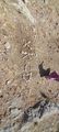
Proof
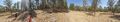
Panorama at the hashpoint


Achievements
Yerushalmi's kids earned the And the Children Shall Lead
|
)