Difference between revisions of "2023-09-06 31 35"
Yerushalmi (talk | contribs) |
Yerushalmi (talk | contribs) |
||
| Line 22: | Line 22: | ||
== Expedition == | == Expedition == | ||
| − | + | I took the 615/617 from Jerusalem to the bus stop on route 38, crossed 38 on a pedestrian footbridge, and walked into the forest. Using Geohash Droid as my map, I had no trouble navigating which paths I needed to take. | |
| − | + | The hashpoint was inside the "elbow" of a path that went from west to east and then hooked to the north. I had to decide whether to go north from the west-east part or go west from the south-north part. | |
| − | |||
| − | + | [[File:Screenshot_20230907_155347_Geohash Droid.jpg|400px]] | |
| − | + | ||
| − | + | Heading north from the west-east part looked too steep to attempt safely: | |
| − | + | ||
| − | + | [[File:20230906_153645.jpg|400px]] | |
| − | |||
| − | + | So I headed past to the elbow and turned north, saying hi as I passed some loggers who were working there. The descent into the valley from the east was far easier: | |
| − | |||
| − | |||
| − | + | [[File:20230906_150854.jpg|400px]] | |
| − | |||
| − | |||
| − | [[ | ||
| + | I got nervous as I approached the point that it might be in the middle of this impassible clump of trees: | ||
| − | [[ | + | [[File:20230906_151855.jpg|400px]] |
| − | + | But it turned out to be a few meters away. | |
| − | + | Walked back the way I came, took the bus back to Jerusalem. Bosh. | |
| − | |||
| − | |||
| − | |||
| − | |||
| − | |||
| − | |||
| − | |||
| − | |||
| − | |||
| + | == Photos == | ||
| + | <gallery> | ||
| + | File:20230906_141435.jpg | Sign at the entrance to the forest | ||
| + | File:20230906_145417.jpg | It would be a nice view if not for the permanent cloud of dust | ||
| + | File:20230906_145433.jpg | I can probably get down here | ||
| + | File:20230906_145538.jpg | ||
| + | File:20230906_150617.jpg | ||
| + | File:20230906_150854.jpg | In the valley | ||
| + | File:20230906_150900.jpg | ||
| + | File:20230906_151823.jpg | Panorama at the point | ||
| + | File:20230906_151855.jpg | ||
| + | File:20230906_153340.jpg | I'm glad I didn't try to go down this way | ||
| + | File:20230906_153645.jpg | A quarry off in the distance | ||
| + | File:20230906_153651.jpg | ||
| + | File:20230906_161318.jpg | A footbridge over route 38 with a "Warning: Danger of falling" sign (not the bridge I used, of course) | ||
| + | File:Screenshot_20230906_151806_Geohash Droid.jpg | Proof | ||
| + | File:Screenshot_20230907_155347_Geohash Droid.jpg | The point relative to the two paths. I came in from the west, turned north at the fork, and approached the point from the east | ||
| + | </gallery> | ||
| − | |||
| − | |||
| − | |||
| − | |||
| − | |||
| − | |||
| − | |||
| − | |||
| − | + | __NOTOC__ | |
| − | |||
| − | |||
| − | |||
| − | |||
| − | + | [[Category:Expeditions]] | |
| + | [[Category:Expeditions with photos]] | ||
| + | [[Category:Coordinates reached]] | ||
Revision as of 13:04, 7 September 2023
| Wed 6 Sep 2023 in 31,35: 31.7917828, 35.0259824 geohashing.info google osm bing/os kml crox |
Location
In Rabin Park, near a quarry outside of Beit Meir
Participants
Plans
At some convenient point today I'll take a bus to the general area, walk to the point, then walk back to the bus station and bus to Jerusalem.
Expedition
I took the 615/617 from Jerusalem to the bus stop on route 38, crossed 38 on a pedestrian footbridge, and walked into the forest. Using Geohash Droid as my map, I had no trouble navigating which paths I needed to take.
The hashpoint was inside the "elbow" of a path that went from west to east and then hooked to the north. I had to decide whether to go north from the west-east part or go west from the south-north part.

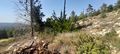
Heading north from the west-east part looked too steep to attempt safely:

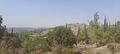
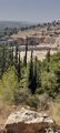
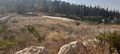
So I headed past to the elbow and turned north, saying hi as I passed some loggers who were working there. The descent into the valley from the east was far easier:

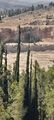
I got nervous as I approached the point that it might be in the middle of this impassible clump of trees:

But it turned out to be a few meters away.
Walked back the way I came, took the bus back to Jerusalem. Bosh.
Photos
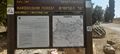
Sign at the entrance to the forest
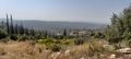
It would be a nice view if not for the permanent cloud of dust
I can probably get down here
In the valley
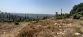
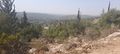
Panorama at the point
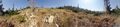
I'm glad I didn't try to go down this way
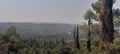
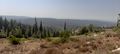
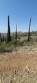
A quarry off in the distance
A footbridge over route 38 with a "Warning: Danger of falling" sign (not the bridge I used, of course)

Proof
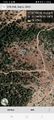
The point relative to the two paths. I came in from the west, turned north at the fork, and approached the point from the east


