Difference between revisions of "2023-09-19 64 25"
| Line 19: | Line 19: | ||
I got off the bus in Kempele and found my way to the hashpoint. It was not raining too hard in the beginning, but during the walk it started to hit harder and harder. I was wise enough to wear rain overalls, but they still could not keep everything away, and I ended up getting noticeably wet. Thankfully, my phone can take a few raindrops, so I could take pictures. The GPS receiver is waterproof and had absolutely no issues. | I got off the bus in Kempele and found my way to the hashpoint. It was not raining too hard in the beginning, but during the walk it started to hit harder and harder. I was wise enough to wear rain overalls, but they still could not keep everything away, and I ended up getting noticeably wet. Thankfully, my phone can take a few raindrops, so I could take pictures. The GPS receiver is waterproof and had absolutely no issues. | ||
| − | + | ... | |
According to the GPS receiver, the length of the trip was 35.7 km, of which I walked 4.8 km and travelled 30.9 km by bus. | According to the GPS receiver, the length of the trip was 35.7 km, of which I walked 4.8 km and travelled 30.9 km by bus. | ||
| Line 27: | Line 27: | ||
== Photos == | == Photos == | ||
| − | + | <gallery perrow="8"> | |
| − | <gallery perrow=" | + | Image:2023-09-19_64_25_01-church.jpg | The church of Kempele. |
| + | Image:2023-09-19_64_25_02-path.jpg | One of the paths I walked along. | ||
| + | Image:2023-09-19_64_25_03-bush.jpg | I had to do a little bushwhacking to get to the forest, 20 metres to go. | ||
| + | Image:2023-09-19_64_25_04-hashpoint.jpg | How the hashpoint surroundings look like. | ||
| + | Image:2023-09-19_64_25_05-gpsr1.jpg | Proof of location. | ||
| + | Image:2023-09-19_64_25_06-gpsr2.jpg | Proof of date and time. | ||
| + | Image:2023-09-19_64_25_07-selfie.jpg | Stupid Grin™ | ||
| + | Image:2023-09-19_64_25_08-bus.jpg | The bus that I took back home. | ||
</gallery> | </gallery> | ||
| Line 43: | Line 50: | ||
| latitude = {{#explode:{{SUBPAGENAME}}| |1}} | longitude = {{#explode:{{SUBPAGENAME}}| |2}} | date = {{#explode:{{SUBPAGENAME}}| |0}} | | latitude = {{#explode:{{SUBPAGENAME}}| |1}} | longitude = {{#explode:{{SUBPAGENAME}}| |2}} | date = {{#explode:{{SUBPAGENAME}}| |0}} | ||
}} | }} | ||
| − | |||
__NOTOC__ | __NOTOC__ | ||
| − | |||
| − | |||
| − | |||
| − | |||
| − | |||
| − | |||
| − | |||
| − | |||
| − | |||
| − | |||
| − | |||
| − | |||
| − | |||
[[Category:Expeditions]] | [[Category:Expeditions]] | ||
| − | |||
[[Category:Expeditions with photos]] | [[Category:Expeditions with photos]] | ||
| − | |||
| − | |||
| − | |||
| − | |||
| − | |||
[[Category:Coordinates reached]] | [[Category:Coordinates reached]] | ||
| − | |||
| − | |||
| − | |||
| − | |||
| − | |||
| − | |||
| − | |||
| − | |||
| − | |||
| − | |||
| − | |||
| − | |||
| − | |||
| − | |||
| − | |||
| − | |||
| − | |||
| − | |||
Revision as of 19:55, 19 September 2023
| Tue 19 Sep 2023 in 64,25: 64.9088785, 25.4623725 geohashing.info google osm bing/os kml crox |
Location
In a birch forest in Hahtoranta, Kempele.
The point on a topographic map: [1]
Participants
Expedition
This geohash happened to be in an easily accessible location and not too far from home. Normally, it would have been well within cycling distance, but since the autumn evening would be rainy, I decided to go by bus and walk a couple of kilometres instead.
Bus lines 50 and 51 between Oulu and Kempele conveniently go near my home. I could choose either of them depending on which one would suit my schedule better. After coming home from work and having a quick dinner, I ended up leaving for the stop of line 51. I was a little slow to leave and had to jog to catch the bus, which I did with about half a minute to spare.
I got off the bus in Kempele and found my way to the hashpoint. It was not raining too hard in the beginning, but during the walk it started to hit harder and harder. I was wise enough to wear rain overalls, but they still could not keep everything away, and I ended up getting noticeably wet. Thankfully, my phone can take a few raindrops, so I could take pictures. The GPS receiver is waterproof and had absolutely no issues.
...
According to the GPS receiver, the length of the trip was 35.7 km, of which I walked 4.8 km and travelled 30.9 km by bus.
Tracklog
Photos
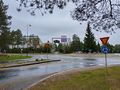
The church of Kempele.
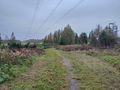
One of the paths I walked along.
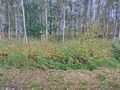
I had to do a little bushwhacking to get to the forest, 20 metres to go.
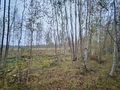
How the hashpoint surroundings look like.
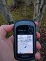
Proof of location.
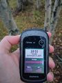
Proof of date and time.
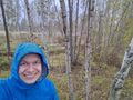
Stupid Grin™
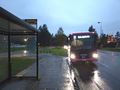
The bus that I took back home.


Achievements
Kripakko earned the Land geohash achievement
|
Kripakko earned the Public transport geohash achievement
|