Difference between revisions of "2023-11-23 32 35"
Yerushalmi (talk | contribs) (Created page with "{{subst:Expedition}}") |
Yerushalmi (talk | contribs) |
||
| Line 13: | Line 13: | ||
}}<!-- edit as necessary --> | }}<!-- edit as necessary --> | ||
== Location == | == Location == | ||
| − | + | Somewhere on the Galilee Cliffs. Only upon arrival will I be able to tell if it's an accessible part or not. | |
== Participants == | == Participants == | ||
| − | + | [[User:Yerushalmi|Yerushalmi]] ([[User talk:Yerushalmi|talk]]) | |
| − | |||
== Plans == | == Plans == | ||
| − | + | I have to be in Qatsrin, so I'll stop by the hash on the way. | |
| + | |||
| + | I have to decide first: Do I start at the bottom of the cliffs or at the top? I have no way of knowing which - if any - will provide an accessible route to the point. | ||
| + | |||
| + | Making the decision for me is the current situation with rocket attacks from Hizbullah in Lebanon. The Galilee Cliffs form the border between two local jurisdictions. The western one (at the bottom of the cliffs) is marked green - no restrictions. The eastern one (at the top of the cliffs) is marked yellow - slightly higher risk of rocket attacks. The point itself is in the green zone, so if I approach from below I'll be in green throughout the expedition. Street View says the road below is lined by greenhouses, but there's plenty of space between and around them. | ||
| + | |||
| + | So the plan is to take a bus to Afula, from there a Qatsrin-bound bus to the Ein Gev resort village, get off, go to the point, come back, take the next bus from the village to Qatsrin. I also printed out maps of the hash area just in case of the intermittent GPS jamming that's been happening in that particular war zone. | ||
== Expedition == | == Expedition == | ||
| − | + | I took the bus to Afula without incident, and boarded the bus to Qatsrin. That's where I got a bit unlucky: my GPS worked perfectly until exactly two stops before the Ein Gev resort, at which point GPS jamming kicked in. By the time I noticed my location wasn't updating the way it should, I had missed my stop and ended up at the Ein Gev kibbutz instead. (GPS jamming ended again almost immediately.) | |
| − | + | No big deal. Wait fifteen, get on the bus going in the opposite direction, get off at the next stop. | |
| − | + | ||
| + | I walked down the highway, past the greenhouses. I was looking for some sort of access road that went around them, but I had to pass up the first two because the roads themselves were marked as private property. Finally I found a road that wasn't marked as such, so I walked up there. | ||
| + | |||
| + | Unfortunately, there was a private property sign only a hundred or so meters down. And the entire area was *severely* overgrown, to the extent that I had no real way around it. | ||
| + | |||
| + | I might have braved it anyway if I had had a lot of extra time and a machete (I should buy a machete, but I would have difficulty boarding buses with it in this country). But instead I turned around and went home. | ||
== Photos == | == Photos == | ||
| Line 33: | Line 43: | ||
--> | --> | ||
<gallery perrow="5"> | <gallery perrow="5"> | ||
| + | Image:20231123_125440.jpg | The no-trespassing sign and overgrowth that stopped me proceeding. | ||
| + | Image:20231123_124752.jpg | The greenhouses on the side of the road. The point is somewhere on the cliff face behind it. | ||
| + | Image:20231123_124755.jpg | The greenhouses on the side of the road. The point is somewhere on the cliff face behind it. | ||
</gallery> | </gallery> | ||
| − | |||
| − | |||
| − | |||
| − | |||
| − | |||
| − | |||
| − | |||
| − | |||
| − | |||
| − | |||
| − | |||
| − | |||
| − | |||
| − | |||
| − | |||
| − | |||
| − | |||
| − | |||
[[Category:Expeditions]] | [[Category:Expeditions]] | ||
| − | |||
[[Category:Expeditions with photos]] | [[Category:Expeditions with photos]] | ||
| − | |||
| − | |||
| − | |||
| − | |||
| − | |||
| − | |||
| − | |||
| − | |||
| − | |||
[[Category:Coordinates not reached]] | [[Category:Coordinates not reached]] | ||
| − | |||
| − | |||
[[Category:Not reached - Mother Nature]] | [[Category:Not reached - Mother Nature]] | ||
| − | |||
| − | |||
[[Category:Not reached - No public access]] | [[Category:Not reached - No public access]] | ||
| − | |||
| − | |||
| − | |||
| − | |||
| − | |||
| − | |||
| − | |||
| − | |||
Revision as of 11:30, 27 November 2023
| Thu 23 Nov 2023 in 32,35: 32.7499223, 35.6485165 geohashing.info google osm bing/os kml crox |
Contents
Location
Somewhere on the Galilee Cliffs. Only upon arrival will I be able to tell if it's an accessible part or not.
Participants
Plans
I have to be in Qatsrin, so I'll stop by the hash on the way.
I have to decide first: Do I start at the bottom of the cliffs or at the top? I have no way of knowing which - if any - will provide an accessible route to the point.
Making the decision for me is the current situation with rocket attacks from Hizbullah in Lebanon. The Galilee Cliffs form the border between two local jurisdictions. The western one (at the bottom of the cliffs) is marked green - no restrictions. The eastern one (at the top of the cliffs) is marked yellow - slightly higher risk of rocket attacks. The point itself is in the green zone, so if I approach from below I'll be in green throughout the expedition. Street View says the road below is lined by greenhouses, but there's plenty of space between and around them.
So the plan is to take a bus to Afula, from there a Qatsrin-bound bus to the Ein Gev resort village, get off, go to the point, come back, take the next bus from the village to Qatsrin. I also printed out maps of the hash area just in case of the intermittent GPS jamming that's been happening in that particular war zone.
Expedition
I took the bus to Afula without incident, and boarded the bus to Qatsrin. That's where I got a bit unlucky: my GPS worked perfectly until exactly two stops before the Ein Gev resort, at which point GPS jamming kicked in. By the time I noticed my location wasn't updating the way it should, I had missed my stop and ended up at the Ein Gev kibbutz instead. (GPS jamming ended again almost immediately.)
No big deal. Wait fifteen, get on the bus going in the opposite direction, get off at the next stop.
I walked down the highway, past the greenhouses. I was looking for some sort of access road that went around them, but I had to pass up the first two because the roads themselves were marked as private property. Finally I found a road that wasn't marked as such, so I walked up there.
Unfortunately, there was a private property sign only a hundred or so meters down. And the entire area was *severely* overgrown, to the extent that I had no real way around it.
I might have braved it anyway if I had had a lot of extra time and a machete (I should buy a machete, but I would have difficulty boarding buses with it in this country). But instead I turned around and went home.
Photos
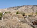
The no-trespassing sign and overgrowth that stopped me proceeding.
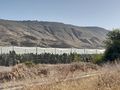
The greenhouses on the side of the road. The point is somewhere on the cliff face behind it.
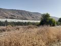
The greenhouses on the side of the road. The point is somewhere on the cliff face behind it.


