Difference between revisions of "2023-12-04 30 35"
Yerushalmi (talk | contribs) (Created page with "{{subst:expedition}}") |
Yerushalmi (talk | contribs) |
||
| Line 13: | Line 13: | ||
}}<!-- edit as necessary --> | }}<!-- edit as necessary --> | ||
== Location == | == Location == | ||
| − | + | In the southern town of Hatzeva. Amud Anan says it's near a recycling plant. A rare chance to finally reach a point in 30 35. | |
== Participants == | == Participants == | ||
| − | + | [[User:Yerushalmi|Yerushalmi]] ([[User talk:Yerushalmi|talk]]) | |
| − | |||
== Plans == | == Plans == | ||
| − | + | Hatzeva's reachability by public transportation is only via buses to Eilat, almost all of which you need to order a seat at least two hours in advance. The Hatzeva bus stop is on route 90 but the town itself is an hour's walk away. | |
| + | |||
| + | So at midnight the night before, I ordered a seat on the 10:00 bus from Jerusalem, and a seat on the 13:00 return bus (which only reaches Hatzeva at 14:30-ish). According to the schedule this gives me about 2.5 hours to get from the bus stop to the point and back. | ||
| + | |||
| + | Worst case scenario, I miss it and I just get on a different bus, right? | ||
== Expedition == | == Expedition == | ||
| − | + | The 10:00 bus left Jerusalem on time (the bus driver doesn't bother checking if you ordered a seat in advance, you just scan your Rav Kav bus card like normal). It drives first east on route 1 to the Dead Sea and then south on route 90 - the lowest-elevation highway in the world. There were fantastic views of cliff faces on the right and the Dead Sea on the left. I was sitting on the right, so cliff faces are what you get: | |
| − | + | [[:File:20231204_104648.mp4]] | |
| − | + | ||
| + | As we approached, I started following closely the Moovit app so I'd know when to get off. This turned out to be a mistake: Even though there are warnings of more-or-less permanent GPS jamming in the North, there is still intermittent GPS jamming elsewhere in the country. It took some time for me to realize the app was stuck for an unusual amount of time three stops before Hatzeva. When somebody else pressed the Stop button, I decided I'd look out the window to see what stop it was they were getting off - and it turned out to be Hatzeva. ''Shirt!'' I gathered my stuff in a hurry. | ||
| + | |||
| + | I needn't have hurried; five or six additional people got off there and had luggage to remove from under the bus as well. But all in all I was *extremely* lucky I didn't miss my stop. | ||
| + | |||
| + | Well, time to prepare for the hour's walk into town. For context, it's a T intersection: route 90 is a straight north-south highway, and the highway to Hatzeva branches off of it to the east. I had gotten off at the bus stop on the west side of route 90, so I needed to cross Route 90 and begin walking east. This I did, but I stopped at another bus shelter (with no labeled bus lines, curious) at the beginning of the Hatzeva highway and begin putting on sunscreen. | ||
| + | |||
| + | While I did so, one of the other people who had gotten off the bus joined me at the shelter - and flagged down a car to hitchhike the rest of the way into town. Aha, that's what the extra bus shelter is for! The car had enough space for two people, so I got a ride into Hatzeva. | ||
| + | |||
| + | I was dropped off three blocks away from the point, so I walked the rest of the way there. I started to get nervous as I approached: the street was lined with a hedge as far as I could see, maybe it's private property? But just before the point there was a break in the hedge, with a broken gate and what was clearly a very empty and unused lot with the remains of some long-disused greenhouse. It was an easy walk to the point. I dug "XKCD" in the sand with my foot (it isn't all that visible), took a panorama, and walked back. | ||
| + | |||
| + | I had brought food with me, so on the way back I stopped to eat it on a bench in a playground, then hitchhiked back to route 90. | ||
| + | |||
| + | The time savings due to hitchhiking in both directions rather than walking meant I not only had over an hour and a half before the return bus that I had ordered, but I could catch an earlier bus - one that didn't require advance seat ordering - and transfer at Ein Gedi to make it home a lot faster. | ||
== Photos == | == Photos == | ||
| − | + | ||
| − | |||
| − | |||
<gallery perrow="5"> | <gallery perrow="5"> | ||
| + | Image:Screenshot_20231204_124146_Geohash Droid.jpg | Proof | ||
| + | Image:20231204_124155.jpg | Writing xkcd (badly) in the ground at the point | ||
| + | Image:20231204_110040.jpg | The Dead Sea | ||
| + | Image:20231204_124202.jpg | Panorama at the point | ||
| + | Image:20231204_151418.jpg | Panorama at the Ein Gedi bus shelter, which was particularly beautiful but I'm terrible at photography. The area behind the bus shelter was labeled with No Entry signs that said "Danger: Sinkholes" and "Danger: Mines", which I should've photographed as well but didn't. | ||
</gallery> | </gallery> | ||
== Achievements == | == Achievements == | ||
{{#vardefine:ribbonwidth|100%}} | {{#vardefine:ribbonwidth|100%}} | ||
| − | + | {{Virgin graticule | |
| − | |||
| − | |||
| − | |||
| − | |||
| − | |||
| − | + | | latitude = 30 | |
| + | | longitude = 35 | ||
| + | | date = 2023-12-04 | ||
| + | | name = Yerushalmi | ||
| + | | image = 20231204_124202.jpg | ||
| − | + | }} | |
| − | |||
| − | |||
| − | |||
| − | + | __NOTOC__ | |
| − | |||
[[Category:Expeditions]] | [[Category:Expeditions]] | ||
| − | |||
[[Category:Expeditions with photos]] | [[Category:Expeditions with photos]] | ||
[[Category:Expeditions with videos]] | [[Category:Expeditions with videos]] | ||
| − | |||
| − | |||
| − | |||
| − | |||
[[Category:Coordinates reached]] | [[Category:Coordinates reached]] | ||
| − | |||
| − | |||
| − | |||
| − | |||
| − | |||
| − | |||
| − | |||
| − | |||
| − | |||
| − | |||
| − | |||
| − | |||
| − | |||
| − | |||
| − | |||
| − | |||
| − | |||
| − | |||
Revision as of 18:58, 4 December 2023
| Mon 4 Dec 2023 in 30,35: 30.7699336, 35.2812192 geohashing.info google osm bing/os kml crox |
Location
In the southern town of Hatzeva. Amud Anan says it's near a recycling plant. A rare chance to finally reach a point in 30 35.
Participants
Plans
Hatzeva's reachability by public transportation is only via buses to Eilat, almost all of which you need to order a seat at least two hours in advance. The Hatzeva bus stop is on route 90 but the town itself is an hour's walk away.
So at midnight the night before, I ordered a seat on the 10:00 bus from Jerusalem, and a seat on the 13:00 return bus (which only reaches Hatzeva at 14:30-ish). According to the schedule this gives me about 2.5 hours to get from the bus stop to the point and back.
Worst case scenario, I miss it and I just get on a different bus, right?
Expedition
The 10:00 bus left Jerusalem on time (the bus driver doesn't bother checking if you ordered a seat in advance, you just scan your Rav Kav bus card like normal). It drives first east on route 1 to the Dead Sea and then south on route 90 - the lowest-elevation highway in the world. There were fantastic views of cliff faces on the right and the Dead Sea on the left. I was sitting on the right, so cliff faces are what you get:
As we approached, I started following closely the Moovit app so I'd know when to get off. This turned out to be a mistake: Even though there are warnings of more-or-less permanent GPS jamming in the North, there is still intermittent GPS jamming elsewhere in the country. It took some time for me to realize the app was stuck for an unusual amount of time three stops before Hatzeva. When somebody else pressed the Stop button, I decided I'd look out the window to see what stop it was they were getting off - and it turned out to be Hatzeva. Shirt! I gathered my stuff in a hurry.
I needn't have hurried; five or six additional people got off there and had luggage to remove from under the bus as well. But all in all I was *extremely* lucky I didn't miss my stop.
Well, time to prepare for the hour's walk into town. For context, it's a T intersection: route 90 is a straight north-south highway, and the highway to Hatzeva branches off of it to the east. I had gotten off at the bus stop on the west side of route 90, so I needed to cross Route 90 and begin walking east. This I did, but I stopped at another bus shelter (with no labeled bus lines, curious) at the beginning of the Hatzeva highway and begin putting on sunscreen.
While I did so, one of the other people who had gotten off the bus joined me at the shelter - and flagged down a car to hitchhike the rest of the way into town. Aha, that's what the extra bus shelter is for! The car had enough space for two people, so I got a ride into Hatzeva.
I was dropped off three blocks away from the point, so I walked the rest of the way there. I started to get nervous as I approached: the street was lined with a hedge as far as I could see, maybe it's private property? But just before the point there was a break in the hedge, with a broken gate and what was clearly a very empty and unused lot with the remains of some long-disused greenhouse. It was an easy walk to the point. I dug "XKCD" in the sand with my foot (it isn't all that visible), took a panorama, and walked back.
I had brought food with me, so on the way back I stopped to eat it on a bench in a playground, then hitchhiked back to route 90.
The time savings due to hitchhiking in both directions rather than walking meant I not only had over an hour and a half before the return bus that I had ordered, but I could catch an earlier bus - one that didn't require advance seat ordering - and transfer at Ein Gedi to make it home a lot faster.
Photos

Proof
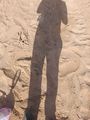
Writing xkcd (badly) in the ground at the point
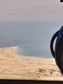
The Dead Sea
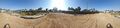
Panorama at the point
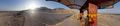
Panorama at the Ein Gedi bus shelter, which was particularly beautiful but I'm terrible at photography. The area behind the bus shelter was labeled with No Entry signs that said "Danger: Sinkholes" and "Danger: Mines", which I should've photographed as well but didn't.


