Difference between revisions of "2024-03-02 56 -3"
| Line 58: | Line 58: | ||
<!-- =============== USEFUL CATEGORIES FOLLOW ================ | <!-- =============== USEFUL CATEGORIES FOLLOW ================ | ||
Delete the next line ONLY if you have chosen the appropriate categories below. If you are unsure, don't worry. People will read your report and help you with the classification. --> | Delete the next line ONLY if you have chosen the appropriate categories below. If you are unsure, don't worry. People will read your report and help you with the classification. --> | ||
| − | |||
<!-- ==REQUEST FOR TWITTER BOT== Please leave either the New report or the Expedition planning category in as long as you work on it. This helps the twitter bot a lot with announcing the right outcome at the right moment. --> | <!-- ==REQUEST FOR TWITTER BOT== Please leave either the New report or the Expedition planning category in as long as you work on it. This helps the twitter bot a lot with announcing the right outcome at the right moment. --> | ||
| − | |||
| − | |||
| − | |||
| − | |||
| − | |||
| − | |||
| − | |||
| − | |||
[[Category:Expeditions]] | [[Category:Expeditions]] | ||
| − | |||
[[Category:Expeditions with photos]] | [[Category:Expeditions with photos]] | ||
| − | |||
| − | |||
| − | |||
| − | |||
| − | |||
[[Category:Coordinates reached]] | [[Category:Coordinates reached]] | ||
| − | |||
| − | |||
| − | |||
| − | |||
| − | |||
| − | |||
| − | |||
| − | |||
| − | |||
| − | |||
| − | |||
| − | |||
| − | |||
| − | |||
| − | |||
| − | |||
| − | |||
| − | |||
Revision as of 16:32, 2 March 2024

| Sat 2 Mar 2024 in 56,-3: 56.4335680, -3.1777383 geohashing.info google osm bing/os kml crox |
Location
On a road near Inchture.
Participants
Plans
Gaelan, and a friend, going to get the Ember to Inchture and walk.
Expedition
Leave home in a hurry to make the bus to Dundee; re-check timetables; go home and eat breakfast.
Leave home again, get the 99 to Dundee; walk over to the Grassmarket "bus stop" for the Ember E3. "Bus stop" is a bit of a strong word here - it's a lay-by with a couple chargers for the electric busses and a "bus parking" sign, but nothing to indicate that you could board a bus here, besides a crowd of others who seem prepared to do so. Sure enough, bus shows up, 10 minutes or so before its scheduled departure; my friend shows up shortly after the bus does; and we're off to Inchture. This is my second time on an Ember bus; they're lovely quiet electric things. Only £2.20 for the 17-minute ride - which shouldn't be notable, but given the state bus prices in Scotland, it's a rather pleasant surprise.
15 minutes later, we're there, on a bus stop on the shoulder of the A90. Cell signal in the village of Inchture is shockingly bad, but thankfully my friend has a better sense of direction than I and we're off in the right direction, despite neither of us having been to the village before. Thankfully, outside the village things improve enough to get a map.
From there, it's a nice walk along quiet country roads, with the A90 roaring by in the distance. The most notable landmark is a farm selling potatoes - but far from the traditional honor system you expect in rural areas like this, they've got a vending machine! Sadly neither of us got a photo of the actual machine, but it's an Amazon locker style thing, where you pay to open a cupboard door and remove the sack of potatoes inside.
The hashpoint itself is conveniently located right on the road; we get the photo and turn back around to Inchture. On the way back, the Ember timetable doesn't line up, so we get the Stagecoach 16 from a stop in the village instead. It's night and day from the Ember; it's a vibrating diesel bus, for one (although not nearly as rattly as some of Stagecoach's fare), and it also takes long detours at each of the A90's junctions to serve a village bus stop; the road network here is not well-designed for local bus service. Once in Dundee, we take a circuitous route into the city center, serving the hospital on the way. All in all, it's timetabled to take 42 minutes - over double the time the Ember took! But it's still faster than waiting for the Ember, barely.
From there it's an uneventful 99 back home.
Photos
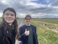
obligatory selfie
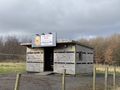
potatoes, anybody?


Achievements
Gaelan earned the Drag-along achievement
|
Gaelan earned the Public transport geohash achievement
|