Difference between revisions of "2013-06-29 42 -96"
From Geohashing
imported>FippeBot m (Location) |
(per Renaming Proposal) |
||
| Line 45: | Line 45: | ||
* Land geohash | * Land geohash | ||
| − | * | + | * Graticule unlocked |
[[Category:Expeditions]] | [[Category:Expeditions]] | ||
| − | [[Category: | + | [[Category:Graticule unlocked achievement]] |
[[Category:Expeditions with photos]] | [[Category:Expeditions with photos]] | ||
[[Category:Coordinates reached]] | [[Category:Coordinates reached]] | ||
{{location|US|NE|TU}} | {{location|US|NE|TU}} | ||
Latest revision as of 03:04, 20 March 2024
| Sat 29 Jun 2013 in 42,-96: 42.0695241, -96.3760538 geohashing.info google osm bing/os kml crox |
Location
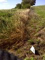
This was right along a minimal maintenance road on the Omaha Nation reservation in Northeast Nebraska.
Participants
Plans
Expedition
Approached it on county roads from the south. Had to drive about 0.7 miles on a minimum maintenance dirt road. Still pretty rutted from recent rains. The hash point was just off this road, next to a soybean field. I left a fully biodegradable flag with the Geohashing Poster for this graticule.
Tracklog
Photos
The Hashpoint

Achievements
- Land geohash
- Graticule unlocked