Difference between revisions of "2010-10-03 64 24"
From Geohashing
imported>FippeBot m (Location) |
m (per Renaming Proposal) |
||
| Line 25: | Line 25: | ||
== Achievements == | == Achievements == | ||
| − | {{ | + | {{Graticule unlocked |
| latitude = 64 | | latitude = 64 | ||
| longitude = 24 | | longitude = 24 | ||
Latest revision as of 06:01, 20 March 2024
| Sun 3 Oct 2010 in Raahe, Finland: 64.8362717, 24.6914929 geohashing.info google osm bing/os kml crox |
Location
Near forest road in Siikajoki municipality Merikylä village.
Participant
Plans
Go to hash place around 17:00 EET. Planning is also get GPS tracks to OpenSourceMap.
Expedition
I had planned a appointment about 10km from hashpoint, so I visited hashpoint after that. This was my second geohashing today. Earlier in the morning I visited in Kempele, Finland. The point was typical finnish forest, with no special items to see. Weather was sunny, +7°C. Autumn colors are just going away, cause trees are dropping leafs. With this expedition I got two new paths to OpenSourceMap.
Photos
Excatly there
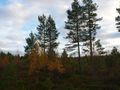
Forest to south from hashpoint
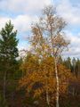
Autumn colors still glow


Achievements
Ossisanni earned the Graticule Unlocked Achievement
|
Ossisanni achieved level 1 of the Minesweeper Geohash achievement
|
Ossisanni earned the Multihash Achievement
|