Difference between revisions of "2008-06-10 40 -97"
From Geohashing
imported>FippeBot m (Location) |
m (per Renaming Proposal) |
||
| Line 26: | Line 26: | ||
== Achievements == | == Achievements == | ||
{{#vardefine:ribbonwidth|800px}} | {{#vardefine:ribbonwidth|800px}} | ||
| − | {{ | + | {{Graticule unlocked | latitude = 40 | longitude = -97 | date = 2008-06-10 | name = [[User:Curtmack|Curtmack]] }} |
[[Category:Expeditions]] | [[Category:Expeditions]] | ||
[[Category:Expeditions with photos]] | [[Category:Expeditions with photos]] | ||
Latest revision as of 07:41, 20 March 2024
| Tue 10 Jun 2008 in Seward, Nebraska: 40.8758452, -97.0997684 geohashing.info google osm bing/os kml crox |
The Location
Curtmack doesn't have a GPS unit, but he theorizes that it's very near the Wal*Mart Supercenter south of Seward, shown below.
The Geohash
Lacking a GPS unit, I (Curtmack) had to use landmarks to find out roughly where the geohash was (and as such couldn't get to its exact location).
More interesting, perhaps, than the geohash itself was one of the landmarks I used: an eerily Pentagon-shaped building, which turned out to be part of a seminary. I took some pictures, which can be found below.
Pictures
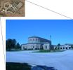
The seminary itself.
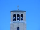
I was there around noon, so these bells actually started ringing while I was there... it was pretty annoying.
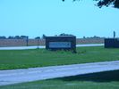
The sign to St. Gregory the Great Seminary.
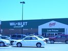
The actual geohash (or close to it anyway).


Achievements
Curtmack earned the Graticule Unlocked Achievement
|