Difference between revisions of "2021-07-11 -37 144"
Felix Dance (talk | contribs) (→Expedition: Added Strava link) |
m (→Participants) |
||
| Line 14: | Line 14: | ||
*[[User:Felix Dance|Felix Dance]] | *[[User:Felix Dance|Felix Dance]] | ||
*[[User:Stevage|Stevage]] | *[[User:Stevage|Stevage]] | ||
| − | *Ruth | + | *[[User:Ruth|Ruth]] |
== Expedition == | == Expedition == | ||
Latest revision as of 12:49, 24 June 2024
| Sun 11 Jul 2021 in -37,144: -37.4553794, 144.3086307 geohashing.info google osm bing/os kml crox |
Location
In Lerderderg State Park west of Melbourne (although it may technically have been in Wombat State Forest).
Participants
Expedition
Stevage first noticed this one. We were hanging out with some friends in the Kyneton region and this geohash seemed to be conveniently located on the way home - not too easy and close to the road, not too inaccessibly far into the bush.
Ruth and I drove towards the hash in Ruth's car after visiting the Kyneton chicken auction, Stevage and his partner Ellen started from Blackwood where they had had Devonshire Tea. Once at the 4WD road entrance we parked up and Stevage, Ruth and I walked in.
Originally, we had wondered if we'd be able to get our cars all the way up to the hash. About 1 second of appraisal of the track dispelled this illusion. The recent storms had smashed the area, throwing enormous trees to the ground across the track and in all other directions.
We half walked, half clambered across the debris-strewn landscape, first crossing a shallow bog, then around the confusing paths at the bottom of the valley adjacent to a creek. Some strange infrastructure had been built around here but we couldn't work out its purpose.
- Water management? Logging? There was a little weir, and power lines which someone had gone to a lot of effort to install here. And a funny little sensor or something sticking out of the ground. -- Stevage
The problem at this stage was that the track up the spur on the other side of the creek to the geohash seemed to be completely absent. It was only after crossing over and bush-bashing over fallen tree trunks up a steep hill that we found it - its lower portions were completely submerged in what used to be treetops.
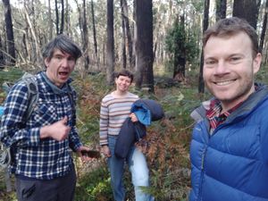
It was still about a 600m walk up the spur, continuing to clamber over the debris, before we reached the hash turn-off. What followed were about 100m of the easiest bush-bash imaginable. Even ground, the odd tuft of bracken - it was in no time that we were celebrating at the hash, our phone GPSs showing adequate precision to call it a win. We took some photos and made our way back to the cars.
- The joy of easily reaching the hash was tempered only by the realisation we had no beer or other way to properly celebrate.
The challenge of getting back over the creek was improved upon by Stevage who managed to clamber his way down the end of the spur and across the creek entirely through the collapsed remnants of an enormous tree canopy. I photographed him not falling into the creek.
- The tree was seriously epic. I've clambered through a couple of fallen tree canopies in my time, but this one took the cake. At times I stepping from branch to branch a couple of metres in the air.
We were back at the cars within the hour and on our way home to our various homely activities.
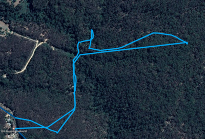
Here is the route we walked:
And here's Stevage's Strava link: [1]


