Difference between revisions of "2024-06-25 58 5"
From Geohashing
(→Photos) |
(→Photos) |
||
| Line 39: | Line 39: | ||
Image:2024-06-25_58_5_Pica42_1719299418659.jpg|Hafrsfjord [https://openstreetmap.org/?mlat=58.92796520&mlon=5.63417590&zoom=16 @58.9280,5.6342] | Image:2024-06-25_58_5_Pica42_1719299418659.jpg|Hafrsfjord [https://openstreetmap.org/?mlat=58.92796520&mlon=5.63417590&zoom=16 @58.9280,5.6342] | ||
| − | Image:20240625 58 5 S.jpg|View to the south | + | Image:20240625 58 5 S.jpg|thumb|View to the south |
| − | + | Image:20240625 58 5 E.jpg|thumb|View to the east | |
Revision as of 11:02, 25 June 2024
| Tue 25 Jun 2024 in 58,5: 58.9279647, 5.6341936 geohashing.info google osm bing/os kml crox |
}}

Location
On the island of Hagøyna in Sola municipality in the fjord Hafrsfjord, Norway.
Participants
Plans
Expedition
Tracklog
Photos

Hafrsfjord @58.9280,5.6342
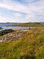
View to the south
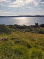
View to the east


Achievements