Difference between revisions of "2024-07-01 51 7"
From Geohashing
(new report) |
(Constant geohasher) |
||
| Line 28: | Line 28: | ||
{{land geohash|date=2024-07-01|latitude=51|longitude=7|name=[[User:Fippe|Fippe]]|image=2024-07-01 51 7 02 Geohash.jpg}} | {{land geohash|date=2024-07-01|latitude=51|longitude=7|name=[[User:Fippe|Fippe]]|image=2024-07-01 51 7 02 Geohash.jpg}} | ||
{{OSM|OSMlink=153426931|date=2024-07-01|latitude=51|longitude=7|name=[[User:Fippe|Fippe]]|image=2024-07-01 51 7 04 Site.jpg}} | {{OSM|OSMlink=153426931|date=2024-07-01|latitude=51|longitude=7|name=[[User:Fippe|Fippe]]|image=2024-07-01 51 7 04 Site.jpg}} | ||
| + | {{constant geohasher|startdate=2018-07-26|startlatitude=40|startlongitude=-73|enddate=2024-07-01|endlatitude=51|endlongitude=7|months=73|name=[[User:Fippe|Fippe]]}} | ||
__NOTOC__ | __NOTOC__ | ||
Latest revision as of 15:40, 21 July 2024
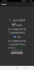
| Mon 1 Jul 2024 in 51,7: 51.5788974, 7.6654063 geohashing.info google osm bing/os kml crox |
Location
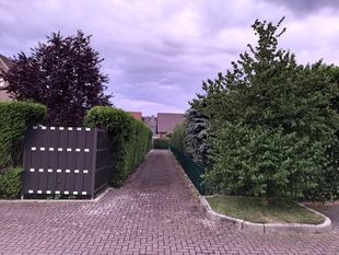
This Geohash is located on a path in Südkamen.
Participants
Expedition
In the evening, I walked to Osnabrück Central, took the train via Münster and Hamm to Kamen and walked the rest of the distance.
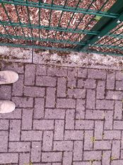
The coordinates were located near the end of a small path leading to a gate to someone's back yard. I was glad to find them to be accessible and recorded proof.
Afterwards, I walked back to the station and took the train via Löhne back home to Osnabrück.
Photos
Tracklog
Ribbons
Fippe earned the Land geohash achievement
|
Fippe earned the OpenStreetMap achievement
|
Fippe earned the Constant geohasher achievement
|


