Difference between revisions of "2024-07-22 49 8"
Green guy! (talk | contribs) (Expedition was successful, more info in a moment) |
Green guy! (talk | contribs) (Write expedition report text; add pictures; tidy everything up) |
||
| Line 8: | Line 8: | ||
}} | }} | ||
== Location == | == Location == | ||
| − | + | On a meadow northeast of Fürth, on the side of an unimproved track road, in Bergstraße (“mountain street”) county, Hesse, Germany. | |
| − | |||
This day’s weather: sunny with a few clouds, about 25 °C | This day’s weather: sunny with a few clouds, about 25 °C | ||
| Line 26: | Line 25: | ||
== Expedition == | == Expedition == | ||
| − | === The way | + | === The way to Fürth === |
| − | + | Due to a road block, it took a few minutes longer than expected to get out of our hometown Darmstadt, which was of no consequence, however. My parents and I drove to Fürth via ''<span style="padding-right: 0.2em">A</span>5'' and ''<span style="padding-right: 0.2em">B</span>460''. As planned, we parked our car on the parking lot of ''Freibad Fürth/Odenwald'' at about 13:30. | |
| − | + | ||
| − | + | === Reaching the coordinates === | |
| − | <gallery class="center" widths=" | + | Walking from the parking lot, we crossed the road next to the roundabout and then had to duck under a single-wire fence (most likely a temporary fence to contain livestock), making our way on a grass-grown track road. |
| − | File: | + | <gallery class="center" widths="300px" heights="200px"> |
| + | File:OMIMG_20240722_133548.jpg|alt="grassy track road, trees in background"|You can’t see the wire on the photo … | ||
| + | File:OMIMG_20240722_133643.jpg|alt="grassy track with trees left and right, meadow straight ahead"|Crossing over the ''Weschnitz'' stream | ||
| + | File:OMIMG_20240722_133745.jpg|alt="grassy track on meadow, cattle in background"|Hashpoint ahead, cattle in background | ||
</gallery> | </gallery> | ||
| − | <gallery class="center" widths=" | + | After crossing over the ''Weschnitz'', we reached the coordinates, which were grown over by knee-tall grass, at 13:38. It was warm and sunny and there were some cattle about 40 meters from us. |
| − | File: | + | <gallery class="center" widths="200px" heights="200px"> |
| + | Screenshot_20240722-133813_OruxMaps.png|alt="OruxMaps screenshot of standing on the coordinates"|Coordinates reached! | ||
| + | File:OMIMG_20240722_133818.jpg|alt="against-the-sun selfie of myself, wearing cap"|Funny grin, camera looking south | ||
| + | File:OMIMG_20240722_133834.jpg|alt="sun-illuminated selfie of myself, wearing cap"|Funny grin, camera looking north | ||
| + | File:OMIMG_20240722_133903.jpg|alt="white cattle next to a fenced paddock"|Zooming in on the cows | ||
</gallery> | </gallery> | ||
| − | <gallery class="center" widths=" | + | Making our way back to the car was simple, reaching it at 13:45. |
| − | File: | + | <gallery class="center" widths="130px" heights="200px"> |
| + | File:OMIMG_20240722_133923.jpg|alt="grassy track road, trees in background, glimpse at road"|Road visible in the background | ||
| + | File:OMIMG_20240722_133954.jpg|alt="stream flowing away from camera, surrounded by shrubs and trees"|The ''Weschnitz'', looking southwest (in flow direction) | ||
| + | File:OMIMG_20240722_134008.jpg|alt="stream flowing towards camera, somewhat hidden by leaves"|The ''Weschnitz'', looking northeast (against the flow) | ||
</gallery> | </gallery> | ||
| − | + | === Having lunch at the restaurant === | |
| − | <gallery class="center" widths=" | + | Next, we drove to ''Europa Ristorante & Bar'' to have lunch. We had a good lunch there, except for some tobacco smoke drafting in from outdoors at the end. |
| − | File: | + | <gallery class="center" widths="200px" heights="200px"> |
| + | File:20240722_142020.jpg|alt="schnitzel covered in cream sauce and mushrooms, with fries next to it"|My father’s lunch: ''Jägerschnitzel'' (escalope chasseur) with french fries | ||
| + | File:20240722_142001 cropped.jpg|alt="Pizza Margherita"|My own lunch: once again, it’s pizza … | ||
| + | File:20240722_142015.jpg|alt="feta cheese with tomatoes and vegetables; thin sticks of bread behind that"|My mother’s lunch: feta cheese with tomatoes and other veggies | ||
</gallery> | </gallery> | ||
| − | + | ||
| − | |||
| − | |||
=== The way back home === | === The way back home === | ||
| + | We contemplated to go for an additional walk in some park or forest after lunch, but we ultimately decided against it, as I cannot handle too many different activities in a single excursion and we were feeling somewhat tired from lunch and sun. The way back home was relaxing and not worth mentioning. | ||
=== Final verdict === | === Final verdict === | ||
| + | Successful short sashay! | ||
| − | == Tracklog: Walking to the hashpoint | + | == Tracklog: Walking to the hashpoint == |
| − | |||
<!-- | <!-- | ||
* I forgot to immediately start the tracklog. | * I forgot to immediately start the tracklog. | ||
| Line 59: | Line 70: | ||
--> | --> | ||
<!-- {{Tracklog|_____.gpx}} --> | <!-- {{Tracklog|_____.gpx}} --> | ||
| − | |||
| − | |||
| − | |||
| − | |||
| − | |||
| − | |||
| − | |||
== Achievements == | == Achievements == | ||
| − | |||
| − | |||
| − | |||
| − | |||
| − | |||
| − | |||
| − | |||
| − | |||
| − | |||
| − | |||
| − | |||
| − | |||
=== Recurring === | === Recurring === | ||
I already earned these from an earlier geohash, but fulfilled the conditions again on this one. | I already earned these from an earlier geohash, but fulfilled the conditions again on this one. | ||
| Line 100: | Line 92: | ||
__NOTOC__ | __NOTOC__ | ||
| − | |||
| − | |||
| − | |||
| − | |||
| − | |||
| − | |||
[[Category:Expeditions]] | [[Category:Expeditions]] | ||
| − | + | [[Category:Expeditions with photos]] | |
| − | |||
| − | |||
| − | |||
[[Category:Coordinates reached]] | [[Category:Coordinates reached]] | ||
| − | |||
{{location|DE|HE|HP}} | {{location|DE|HE|HP}} | ||
Revision as of 16:49, 22 July 2024
| Mon 22 Jul 2024 in 49,8: 49.6581624, 8.7893778 geohashing.info google osm bing/os kml crox |
Location
On a meadow northeast of Fürth, on the side of an unimproved track road, in Bergstraße (“mountain street”) county, Hesse, Germany.
This day’s weather: sunny with a few clouds, about 25 °C
Participants
- Green guy! (talk)
- Green guy!’s mother
- Green guy!’s father
Plans
- Drive to Fürth in the noon
- Park our car next to the public bath Freibad Fürth/Odenwald
- Go on a walk to visit the hashpoint (estimated hashpoint arrival at 13:30–13:45)
- Have lunch at a restaurant
- Drive back home
Expedition
The way to Fürth
Due to a road block, it took a few minutes longer than expected to get out of our hometown Darmstadt, which was of no consequence, however. My parents and I drove to Fürth via A5 and B460. As planned, we parked our car on the parking lot of Freibad Fürth/Odenwald at about 13:30.
Reaching the coordinates
Walking from the parking lot, we crossed the road next to the roundabout and then had to duck under a single-wire fence (most likely a temporary fence to contain livestock), making our way on a grass-grown track road.
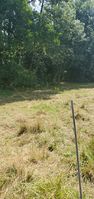
You can’t see the wire on the photo …
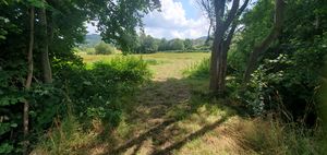
Crossing over the Weschnitz stream
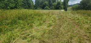
Hashpoint ahead, cattle in background


After crossing over the Weschnitz, we reached the coordinates, which were grown over by knee-tall grass, at 13:38. It was warm and sunny and there were some cattle about 40 meters from us.
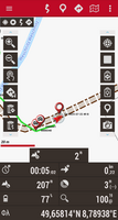
Coordinates reached!
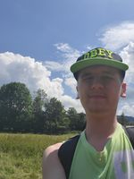
Funny grin, camera looking south

Funny grin, camera looking north
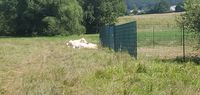
Zooming in on the cows


Making our way back to the car was simple, reaching it at 13:45.
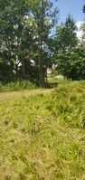
Road visible in the background
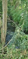
The Weschnitz, looking southwest (in flow direction)
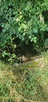
The Weschnitz, looking northeast (against the flow)


Having lunch at the restaurant
Next, we drove to Europa Ristorante & Bar to have lunch. We had a good lunch there, except for some tobacco smoke drafting in from outdoors at the end.
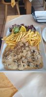
My father’s lunch: Jägerschnitzel (escalope chasseur) with french fries

My own lunch: once again, it’s pizza …
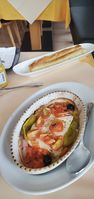
My mother’s lunch: feta cheese with tomatoes and other veggies


The way back home
We contemplated to go for an additional walk in some park or forest after lunch, but we ultimately decided against it, as I cannot handle too many different activities in a single excursion and we were feeling somewhat tired from lunch and sun. The way back home was relaxing and not worth mentioning.
Final verdict
Successful short sashay!
Tracklog: Walking to the hashpoint
Achievements
Recurring
I already earned these from an earlier geohash, but fulfilled the conditions again on this one.
Green guy! earned the Land geohash achievement
|