Difference between revisions of "2024-07-24 65 28"
(Created page with "{{subst:expedition}}") |
|||
| Line 1: | Line 1: | ||
| − | + | {{meetup graticule|date=2024-07-24|lat=65|lon=28}} | |
| − | + | == Location == | |
| − | + | In a forest in Kettukangas, Kuolio, Kuusamo. | |
| − | |||
| − | |||
| − | |||
| − | + | The point on a topographic map: [https://kripakko.neocities.org/geohash_maplink?{{#replace:{{SUBPAGENAME}}| |_}}K] | |
| − | |||
| − | |||
| − | |||
== Participants == | == Participants == | ||
| − | + | * [[User:Kripakko|Kripakko]] | |
| − | + | * Kripakko's fiancée | |
| − | |||
| − | |||
| − | |||
== Expedition == | == Expedition == | ||
| − | + | We were driving by, and I noticed this geohash pretty close to the main road, | |
| − | + | so it would be easy and quick enough to visit. | |
| − | + | The plan was simple: drive to the nearest point on the road and walk to the hashpoint, | |
| − | + | which should be only a quick diversion. | |
| + | However, to our surprise, the last road was closed with a barrier. | ||
| + | Fair enough; assuming that it is a privately funded road, | ||
| + | the road owners are allowed to prohibit any motorised traffic from outsiders. | ||
| + | Using it on foot was perfectly legal though, | ||
| + | so I ran the last 1.3 kilometres to the hashpoint alone | ||
| + | while Fiancée waited in the car. | ||
| + | I tried to be quick because she was waiting for me | ||
| + | and because there were countless mosquitoes thirsty for blood, | ||
| + | but I still lost my sense of time when I stopped to eat some ripe berries. | ||
| + | I eventually ran back to the car, and we got to carry on with our journey. | ||
== Photos == | == Photos == | ||
| − | < | + | <gallery perrow="8"> |
| − | Image:2024- | + | Image:2024-07-24_65_28_01-road1.jpg|The road was blocked and I had to continue on foot. About 1.3 km to go. |
| − | -- | + | Image:2024-07-24_65_28_02-road2.jpg|I eventually had to enter the forest. About 80 m to go. |
| − | + | Image:2024-07-24_65_28_03-qdgn.png|Proof of location and time, screenshot of [https://kripakko.neocities.org/qdgn QDGN]. | |
| + | Image:2024-07-24_65_28_04-selfie.jpg|Selfie at the hashpoint. | ||
| + | Image:2024-07-24_65_28_05-berries1.jpg|Ripe bilberries (''Vaccinium myrtillus''). | ||
| + | Image:2024-07-24_65_28_06-mushrooms.jpg|Rufous milkcaps (''Lactarius rufus''), edible mushrooms after [https://en.wikipedia.org/wiki/Blanching_(cooking) blanching]. | ||
| + | Image:2024-07-24_65_28_07-berries2.jpg|Ripe crowberries (''Empetrum nigrum''). | ||
| + | Image:2024-07-24_65_28_08-reindeer.jpg|A lone reindeer by the road. | ||
</gallery> | </gallery> | ||
== Achievements == | == Achievements == | ||
| − | {{ | + | {{land geohash |
| − | + | | latitude=65 | |
| + | | longitude=28 | ||
| + | | date=2024-07-24 | ||
| + | | name=[[User:Kripakko|Kripakko]] | ||
| + | }} | ||
__NOTOC__ | __NOTOC__ | ||
| − | |||
| − | |||
| − | |||
| − | |||
| − | |||
| − | |||
| − | |||
| − | |||
| − | |||
| − | |||
[[Category:Expeditions]] | [[Category:Expeditions]] | ||
| − | |||
[[Category:Expeditions with photos]] | [[Category:Expeditions with photos]] | ||
| − | |||
| − | |||
| − | |||
| − | |||
[[Category:Coordinates reached]] | [[Category:Coordinates reached]] | ||
| − | |||
| − | |||
| − | |||
| − | |||
| − | |||
| − | |||
| − | |||
| − | |||
| − | |||
| − | |||
| − | |||
| − | |||
| − | |||
| − | |||
Revision as of 07:53, 25 July 2024
| Wed 24 Jul 2024 in 65,28: 65.8600000, 28.8109109 geohashing.info google osm bing/os kml crox |
Location
In a forest in Kettukangas, Kuolio, Kuusamo.
The point on a topographic map: [1]
Participants
- Kripakko
- Kripakko's fiancée
Expedition
We were driving by, and I noticed this geohash pretty close to the main road, so it would be easy and quick enough to visit. The plan was simple: drive to the nearest point on the road and walk to the hashpoint, which should be only a quick diversion. However, to our surprise, the last road was closed with a barrier. Fair enough; assuming that it is a privately funded road, the road owners are allowed to prohibit any motorised traffic from outsiders. Using it on foot was perfectly legal though, so I ran the last 1.3 kilometres to the hashpoint alone while Fiancée waited in the car. I tried to be quick because she was waiting for me and because there were countless mosquitoes thirsty for blood, but I still lost my sense of time when I stopped to eat some ripe berries. I eventually ran back to the car, and we got to carry on with our journey.
Photos
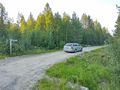
The road was blocked and I had to continue on foot. About 1.3 km to go.
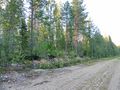
I eventually had to enter the forest. About 80 m to go.
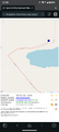
Proof of location and time, screenshot of QDGN.
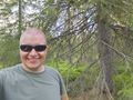
Selfie at the hashpoint.
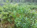
Ripe bilberries (Vaccinium myrtillus).
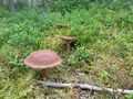
Rufous milkcaps (Lactarius rufus), edible mushrooms after blanching.
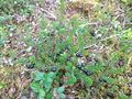
Ripe crowberries (Empetrum nigrum).
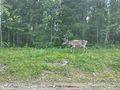
A lone reindeer by the road.


Achievements
Kripakko earned the Land geohash achievement
|