Difference between revisions of "2024-07-29 58 5"
From Geohashing
(→Photos) |
(→Expedition) |
||
| Line 27: | Line 27: | ||
== Expedition == | == Expedition == | ||
<!-- how it all turned out. your narrative goes here. --> | <!-- how it all turned out. your narrative goes here. --> | ||
| + | |||
| + | Today I had forgotten that I planned to find a Geohash. Fortunately, my wife has a better memory than I do. The trip was about 13 km by car, then a little more than a hundred meters to walk. Not far from ground zero is a sign with a wolf. | ||
== Tracklog == | == Tracklog == | ||
Revision as of 15:53, 29 July 2024
| Mon 29 Jul 2024 in 58,5: 58.8508491, 5.7588332 geohashing.info google osm bing/os kml crox |

Location
On the mountain Skjeraberget in the Hana district, Sandnes, Norway
Participants
- Pica42
- pica42's wife
Plans
Expedition
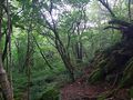
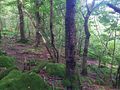
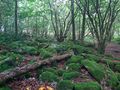
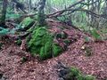
Today I had forgotten that I planned to find a Geohash. Fortunately, my wife has a better memory than I do. The trip was about 13 km by car, then a little more than a hundred meters to walk. Not far from ground zero is a sign with a wolf.
Tracklog
Photos

Sandnes @58.8509,5.7588

Sandnes @58.8508,5.7588
View to the northwest
View to the southwest
View to the southeast
View to the northeast
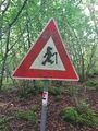
Wolf


Achievements