Difference between revisions of "2024-08-23 52 9"
Coyotebush (talk | contribs) ([live picture]Swimming beach by the lake [https://openstreetmap.org/?mlat=52.49348611&mlon=9.33457222&zoom=16 @52.4935,9.3346]) |
Coyotebush (talk | contribs) (story) |
||
| Line 17: | Line 17: | ||
== Expedition == | == Expedition == | ||
| + | *Bus transfer ended up tight, but successful -- [[User:Coyotebush|Coyotebush]] ([[User talk:Coyotebush|talk]]) [https://openstreetmap.org/?mlat=52.50433078&mlon=9.45613997&zoom=16 @52.5043,9.4561] 10:45, 23 August 2024 (GMT+02:00) | ||
| + | |||
| + | The road heading west out of Neustadt is straight and flat. It also turned out to be beautiful, narrow, lumpy, and limited to 30 km/h. So the 835 bus went slowly. I got off at Strandhotel just as a return bus was boarding a large group of children. Only then did I notice the buses were towing large but empty bike trailers - cool to have lots of capacity for bringing bikes to the lake. | ||
| + | Easy walk along the path parallel to the road, then an unpaved track heading north. Didn't even have to step off the track to reach the point. | ||
| + | Afterwards, I crossed back over the road to head south towards the lake. The closest beach was the swimming beach, where various entertainment equipment was getting set up. Beyond that was a path, fenced in on both sides, through a forest. I ultimately caught the return bus at Mardorf/Erlenweg, possibly the same bus and driver. | ||
| − | |||
== Photos == | == Photos == | ||
<!-- | <!-- | ||
| Line 44: | Line 48: | ||
== Achievements == | == Achievements == | ||
{{#vardefine:ribbonwidth|100%}} | {{#vardefine:ribbonwidth|100%}} | ||
| + | {{Public transport geohash | ||
| − | + | | latitude = 52 | |
| − | + | | longitude = 9 | |
| − | + | | date = 2024-08-23 | |
| + | | name = coyotebush | ||
| + | | image = 2024-08-23_52_9_coyotebush_1724404463044.jpg | ||
| − | + | }} | |
| + | __NOTOC__ | ||
[[Category:Expeditions]] | [[Category:Expeditions]] | ||
| Line 56: | Line 64: | ||
[[Category:Coordinates reached]] | [[Category:Coordinates reached]] | ||
| − | |||
| − | |||
| − | |||
| − | |||
| − | |||
| − | |||
| − | |||
| − | |||
Revision as of 14:49, 23 August 2024
| Fri 23 Aug 2024 in 52,9: 52.4988125, 9.3351287 geohashing.info google osm bing/os kml crox |
Location
Next to a path in a forest near Steinhuder Meer.
Participants
Plans
Morning visit. Bus from the Neustadt am Rübenberge station to Mardorf/Strandhotel, 400m from the point. Likely hang out by the lake until a return bus.
Expedition
- Bus transfer ended up tight, but successful -- Coyotebush (talk) @52.5043,9.4561 10:45, 23 August 2024 (GMT+02:00)
The road heading west out of Neustadt is straight and flat. It also turned out to be beautiful, narrow, lumpy, and limited to 30 km/h. So the 835 bus went slowly. I got off at Strandhotel just as a return bus was boarding a large group of children. Only then did I notice the buses were towing large but empty bike trailers - cool to have lots of capacity for bringing bikes to the lake.
Easy walk along the path parallel to the road, then an unpaved track heading north. Didn't even have to step off the track to reach the point.
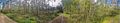
Afterwards, I crossed back over the road to head south towards the lake. The closest beach was the swimming beach, where various entertainment equipment was getting set up. Beyond that was a path, fenced in on both sides, through a forest. I ultimately caught the return bus at Mardorf/Erlenweg, possibly the same bus and driver.
Photos
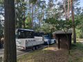
Goodbye bus
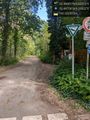
Kolkdobbenweg @52.4975,9.3352
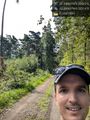
Grin @52.4988,9.3351
Panorama
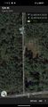
Map screenshot
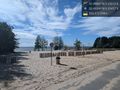
Swimming beach by the lake @52.4935,9.3346


Achievements
coyotebush earned the Public transport geohash achievement
|